Showers Mainly For South Alabama Today; Rain Statewide Tomorrow
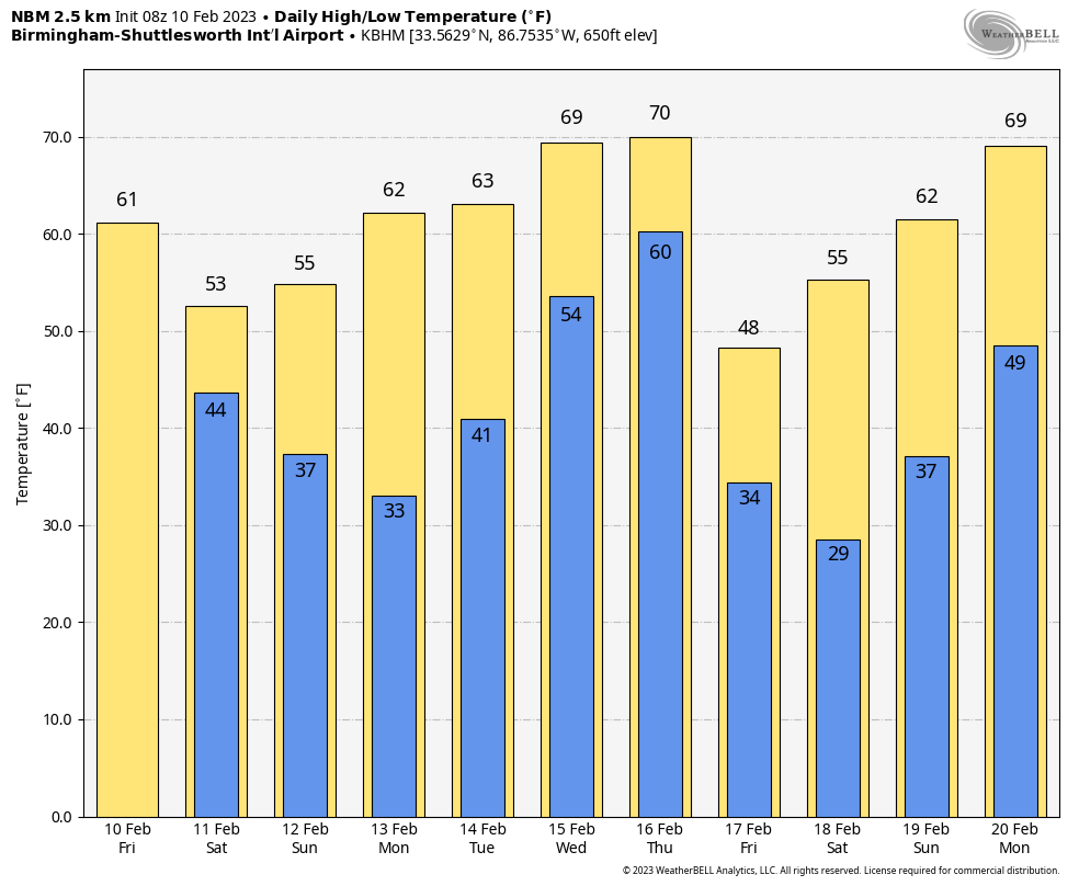
RADAR CHECK: We have a few showers in progress over parts of East and South Alabama early this morning…. generally south of a line from Mobile to Montgomery to Lafayette. Showers will remain possible for the southern part of the state today, but North Alabama will be mostly dry with some sun. Expect highs in the 60s.
THE ALABAMA WEEKEND: Clouds will increase tonight, and we expect a cloudy, colder day tomorrow with occasional rain as an upper trough moves over the state. There is a chance the rain could briefly change to light snow before ending late tomorrow night and early Sunday across parts of North and East Alabama thanks to dynamic cooling from the cold core upper trough/low. For now, we are not expecting major accumulation or impact with surface temperatures above freezing, but keep in mind these systems usually bring a surprise or two, so keep an eye on the forecast for potential changes.
The sky will clear Sunday afternoon… highs will be mostly in the 50s.
NEXT WEEK: Monday will be a sunny, pleasant day with a high in the 60s. Rain moves into the state Tuesday night, and will likely linger into Wednesday as a surface front becomes nearly stationary across the state. A few thunderstorms could be involved, but for now severe storms are not expected during this time frame.
A more dynamic system will impact the state Thursday, and from time to time global models have shown signals that severe storms will be possible with this one. Way too early to be specific, but something to keep an eye on. Then, drier and colder air returns by Friday and the following weekend. See the daily Weather Briefing video for maps, graphics, and more details.
ON THIS DATE IN 1899: One of the most significant cold outbreaks to ever impact the United States occurred early to mid-February. The cold across the middle of the country was so extreme and persistent that ice floes down the Mississippi River into the deep south, emerging into the Gulf of Mexico near New Orleans on February 17th. This has happened only one other time: February 13, 1784.
ON THIS DATE IN 1921: Gardner, Georgia, was devastated by a massive, estimated F4 tornado that caused an entire small town section to disappear. The tornado killed an estimated 31 people and injured 100.
ON THIS DATE IN 1959: St. Louis, Missouri, was hit by a massive F4 tornado that killed 21 and injured 345. Over 2000 buildings were damaged or destroyed, including the St. Louis Arena.
ON THIS DATE IN 1981: A morning tornado at Bay Minette struck the local middle school severely damaging the gymnasium. The tornado hurt 62 people were injured, 44 of whom were students.
BEACH FORECAST: Click here to see the AlabamaWx Beach Forecast Center page.
Just one Weather Briefing video today due to travel (I am speaking today at Ohio State University)… but I will post fresh forecast notes here this afternoon. Enjoy the day!
Category: Alabama's Weather, ALL POSTS, Weather Xtreme Videos
About the Author (Author Profile)
James Spann is one of the most recognized and trusted television meteorologists in the industry. He holds the AMS CCM designation and television seals from the AMS and NWA. He is a past winner of the Broadcast Meteorologist of the Year from both professional organizations.Subscribe
If you enjoyed this article, subscribe to receive more just like it.


