Record Warmth Possible Again Today; Cooler Tomorrow
RADAR CHECK: Showers have formed across Alabama early this morning… otherwise the sky is mostly cloudy with temperatures close to 70 degrees at daybreak. We note that is nine degrees warmer than the average high for this date (61) at Birmingham. Temperatures will rise into the 78-84 degree range again this afternoon, and more daily records are possible. The sky becomes partly sunny this afternoon, with a few isolated showers around through tonight.
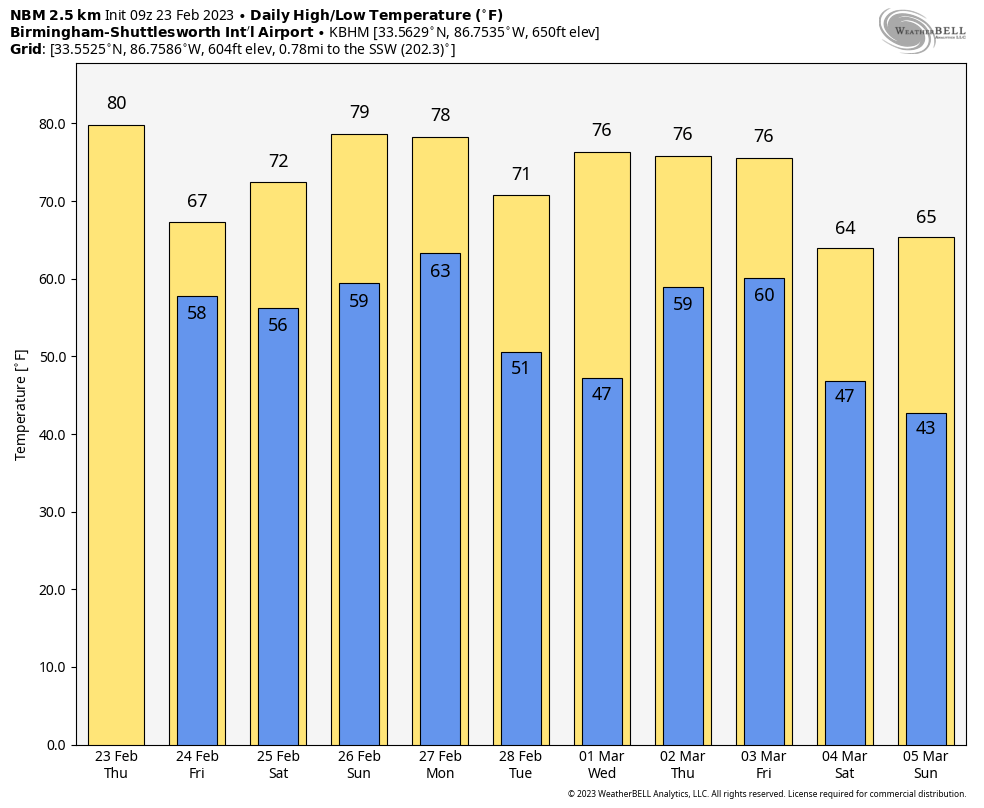
FRIDAY AND THE WEEKEND: Cooler air dips into the state tomorrow; highs will range from near 60 over the Tennessee Valley to the 70s for South Alabama. Showers are possible tomorrow the northern half of the state. Then, for the weekend, highs will be in the 70s statewide. While South Alabama will remain mostly dry, a few scattered showers are possible Saturday and Sunday to the north. Again, nothing too widespread or heavy.
NEXT WEEK: A cold front will bring a chance of showers, and possibly a thunderstorm Monday, but for now severe storms are not expected thanks to the upper ridge, and limited instability. Dry weather is likely Tuesday through Thursday, followed by a chance of rain and storms Friday. Highs through the week will be mostly in the 70s… See the daily Weather Briefing video for maps, graphics, and more details.
RECORD WARMTH: Here are some of the official highs across Alabama yesterday….
Troy 85
Montgomery 84
Tuscaloosa 83 (ties the record for the date)
Muscle Shoals 83 (new record; old record was 79 set in 1909)
Dothan 83
Birmingham 82 (new record; old record was 81 set in 1897 and 2018)
Anniston 82 (ties the record for the date)
Auburn 82
Mobile 82 (new record; old record was 81 set in 2022 and 2018)
Huntsville 81 (new record; old record was 77 set in 2018)
Gadsden 81
ON THIS DATE IN 1975: The F4 tornado that struck Tuscaloosa on February 23, 1975 just before 2 p.m. CST was not only the strongest tornado that struck the State of Alabama that year, it was the deadliest. The tornado first touched down in the Taylorville community and then skipped northeastward before hitting the Skyland Park area and moving on to the McFarland Blvd. exit area of I-59/20. It went on to affect parts of the Alberta City-Leland Park area and on to Holt. The tornado moved right over what is now University Mall; in 1975 it was the old Northington campus, once home to American GIs and hospital patients.
The official path length was 14.4 miles. Along it, 289 homes were destroyed or heavily damaged, along with 20 businesses and 21 mobile homes. The tornado nearly destroyed the new Scottish Inn motel on I-59 at McFarland. The fatality was a 23 year old housekeeper named Thelma Hill, killed when most of the second floor of the motel was sheared away by the tornado causing a wall to fall on her.
BEACH FORECAST: Click here to see the AlabamaWx Beach Forecast Center page.
Look for the next video briefing here by 3:00 this afternoon… enjoy the day!
Category: Alabama's Weather, ALL POSTS, Weather Xtreme Videos
About the Author (Author Profile)
James Spann is one of the most recognized and trusted television meteorologists in the industry. He holds the AMS CCM designation and television seals from the AMS and NWA. He is a past winner of the Broadcast Meteorologist of the Year from both professional organizations.Subscribe
If you enjoyed this article, subscribe to receive more just like it.


