Warm, Dry Today; Severe Storms Late Tomorrow Night
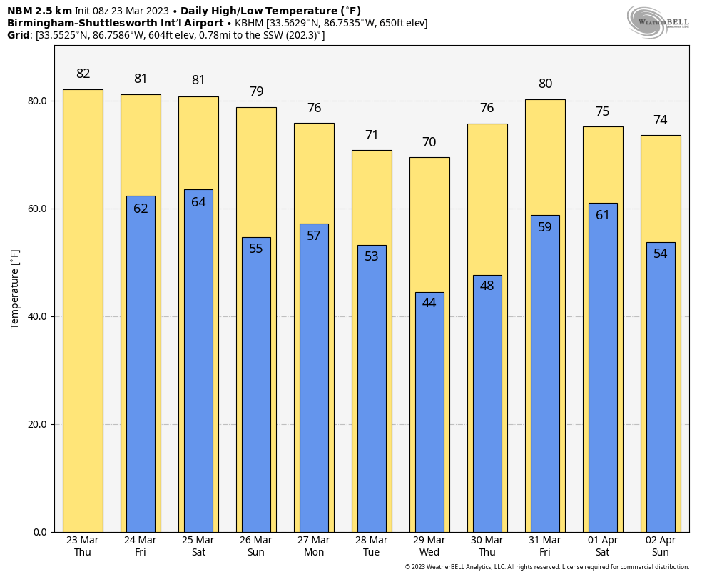
WARM MARCH DAY: With a mostly sunny sky, we are forecasting a high in the 81-85 degree range this afternoon, making it one of the warmest days so far in 2023. The average high for Birmingham on March 23 is 69. The day tomorrow will also be warm and dry with a high in the low 80s.
TOMORROW NIGHT/EARLY SATURDAY: A dynamic weather system will bring the potential for severe thunderstorms to Alabama late tomorrow night into the pre-dawn hours Saturday.The synoptic scale setup certainly favors severe storms, and instability values will be increasing during the night. SPC has defined an “enhanced risk” (level 3/5) of severe thunderstorms for Northwest Alabama, including places like Florence, Russellville, Hamilton, Winfield, Fayette, Vernon, and Gordon. A “slight risK” (level 2/5) extends as far east as Weiss Lake, Sylacauga, and Jackson. A “marginal risk” (level 1/5) covers the rest of East and South Alabama.
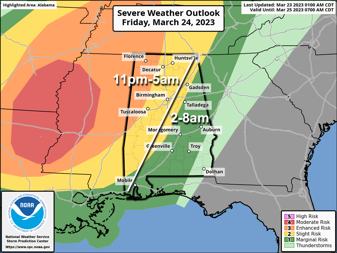
This outlook is valid through 7:00 a.m. Saturday. We note a “marginal risk” (level 1/5) continues after 7:00 a.m. for the southeast corner of the state, including Dothan.
A broken line of strong to severe thunderstorms will move through the state during the overnight hours late tomorrow night and early Saturday. The main threat will come from strong, potentially damaging straight line winds, but a few tornadoes are likely as well, especially in the “enhanced risk” area. Some hail is possible as well.
With events like this it is very important that you have a way of hearing weather warnings in the middle of the night. The baseline for every home and business is a NOAA Weather Radio. Be sure your phone has WEA (Wireless Emergency Alerts) enabled, and “Do Not Disturb” is not active. Know the safe place in your home, and have helmets for everyone in the family there.
If you live in a mobile home, know the location of the nearest shelter (or business that is open 24/7 that can serve as a shelter), and the fastest way of getting there. Have transportation available. It sure isn’t convenient going to a shelter during the pre-dawn hours, but you can’t risk your life staying in a mobile home if you are in a tornado warning polygon.
Rain amounts will average 1/2 to 1 inch… for now flooding issues are not expected.
REST OF THE WEEKEND: The sky becomes mostly sunny Saturday afternoon over much of Alabama as dry air returns; the day will be warm with a high in the low 80s in most communities. The front will stall out over South Alabama, drifting slowly northward Sunday. Showers and storms return Sunday, mainly over the southern 2/3 of the state. The air will be unstable, and strong storms are possible Sunday afternoon, with the main threats coming from strong winds and hail. The high Sunday will be in the upper 70s.
NEXT WEEK: Showers and storms remain possible mainly over the southern half of Alabama Monday, and then statewide Tuesday. Wednesday and Thursday look dry and pleasant before another chance of showers and storms at the end of the week Friday/Friday night. See the video briefing for maps, graphics, and more details.
ON THIS DATE IN 1907: Today was the warmest March day ever recorded in Washington, DC with a maximum temperature of 93 degrees. Washington DC has seen three, 90 degrees days in March, all of which occurred in 1907.
ON THIS DATE IN 1913: A significant tornado outbreak occurred in eastern Nebraska and western Iowa on this day. Seven estimated F2 or stronger tornadoes killed 168 people and caused extensive damage to the area on Easter Sunday.
BEACH FORECAST: Click here to see the AlabamaWx Beach Forecast Center page.
Look for the next video briefing here by 3:00 this afternoon… enjoy the day!
Category: Alabama's Weather, ALL POSTS, Weather Xtreme Videos
About the Author (Author Profile)
James Spann is one of the most recognized and trusted television meteorologists in the industry. He holds the AMS CCM designation and television seals from the AMS and NWA. He is a past winner of the Broadcast Meteorologist of the Year from both professional organizations.Subscribe
If you enjoyed this article, subscribe to receive more just like it.


