Summer-Like Warmth Through Tomorrow; Only Isolated Showers
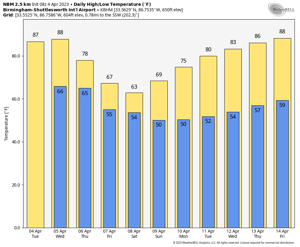
VERY WARM: We are forecasting highs in the 84-88 degree range across Alabama today and tomorrow… it will be the warmest weather so far this year. Morning clouds will give way to a partly sunny sky both days with just a few isolated afternoon and evening showers and thunderstorms…. the chance of any one spot seeing rain each day is in the 10-20 percent range.
These are the record highs for Birmingham…
Today (April 4) 88 set in 1934
Tomorrow (April 5) 88 set in 2010
We probably won’t break those daily records, but we will be close.
An organized mass of rain and storms will likely enter the northwest corner of the state tomorrow night ahead of a surface front; SPC has defined a “slight risk” (level 2/5) of severe thunderstorms for the northwest corner of the state around the Shoals, and a “marginal risk” down to Huntsville, Carbon Hill, and Reform.
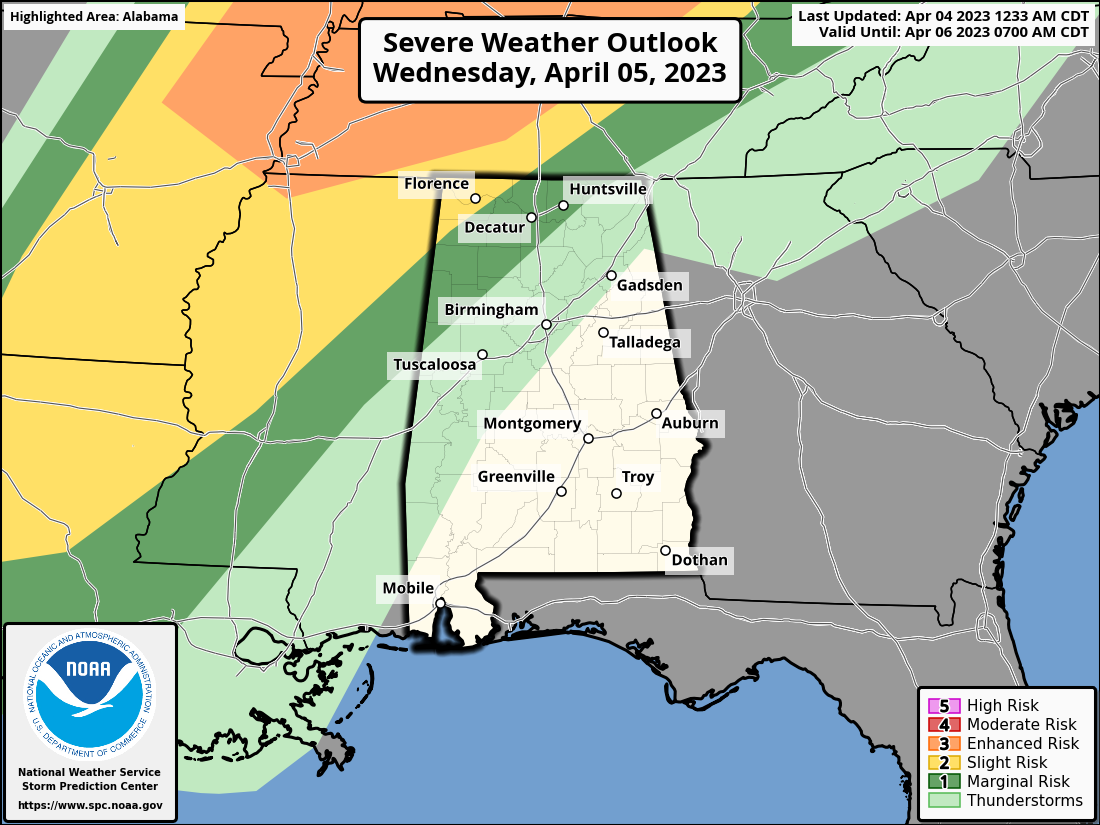
A few storms across Northwest Alabama could produce strong gusty winds and hail tomorrow night; the tornado risk is low. The front will drift into Central Alabama and become nearly stationary Thursday; this will bring periods of rain to the state Thursday and Friday with a big temperature contrast. Temperatures will range from the 60s across North Alabama to the 80s over the southern quarter of the state due to the stalled front. There could be a rumble of thunder, but no severe storms are expected.
EASTER WEEKEND: We will maintain the chance of showers Saturday, especially during the morning hours, but at this point Sunday looks dry with ample sunshine. The high Saturday will be in the low to mid 60s across North Alabama, with 70s to the south. All of the state will enjoy highs in the 70s Sunday.
NEXT WEEK: Models are converging on a solution involving a building upper ridge, which will likely bring above average temperatures and little rain through the week. The idea of a late season cold snap is off the board, and we can pretty much give a green light to those wanting to plant based on this pattern. We always have some risk of a frost morning for colder spots in mid to late April, but odds of a significant freeze or widespread frost now look very low. See the video briefing for maps, graphics, and more details.
ON THIS DATE IN 1977: A violent F5 tornado tore through the northern part of Birmingham. It began around 3 pm, 4 miles northwest of downtown Birmingham near U.S. Highway 78, and then traveled northeast for 15 miles at 60 mph, crossing Interstate 65. At its widest point, the tornado was 3/4 of a mile wide. Over 150 homes were damaged with almost 50 completely destroyed; the Smithfield neighborhood was especially hard hit. A total of 22 people were killed with over 130 injured. There were six other tornadoes on this day including five F2 tornadoes and an F3 tornado across North and Central Alabama.
The same thunderstorm complex was responsible for the crash of Southern Airways Flight 242 in Georgia; it was a flight from Huntsville to Atlanta. The passenger jet went down after suffering hail damage and losing thrust on both engines; Sixty-three people on the aircraft (including the flight crew) and nine people on the ground died; twenty passengers survived, as well as the two flight attendants. One of the initial survivors succumbed to his injuries several weeks later.
BEACH FORECAST: Click here to see the AlabamaWx Beach Forecast Center page.
Look for the next video briefing here by 3:00 this afternoon… enjoy the day!
Category: Alabama's Weather, ALL POSTS, Weather Xtreme Videos
About the Author (Author Profile)
James Spann is one of the most recognized and trusted television meteorologists in the industry. He holds the AMS CCM designation and television seals from the AMS and NWA. He is a past winner of the Broadcast Meteorologist of the Year from both professional organizations.Subscribe
If you enjoyed this article, subscribe to receive more just like it.


