Strong Storms Approaching West Alabama
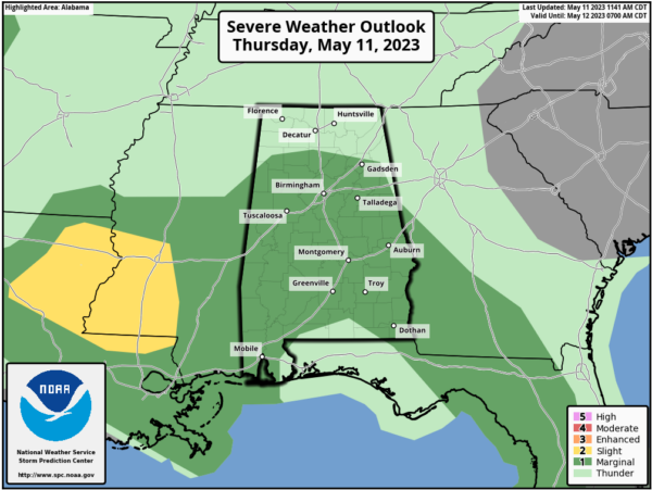
RADAR CHECK: A thunderstorm is over the northeast corner of Alabama at mid-afternoon, otherwise the rest of the state is dry, warm, and humid with temperatures in the 80s. We are watching a line of strong to severe thunderstorms over Central Mississippi; these will enter the western counties of the state later today with potential for strong/damaging winds. SPC has much of the state in a “marginal risk” (level 1/5) of severe thunderstorms through tonight.
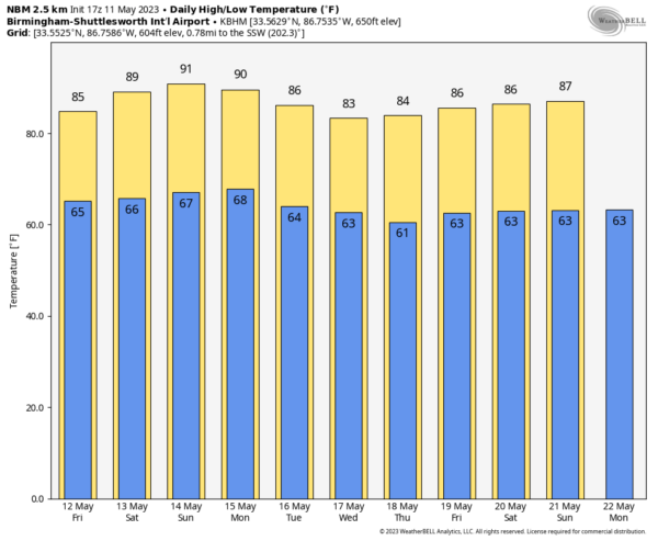
Storms will diminish late tonight. Tomorrow will be another warm, humid day with scattered showers and storms… the high will be in the mid 80s for most places.
THE WEEKEND: The upper ridge will be a tad stronger, and the air a bit more stable. Expect a mix of sun and clouds Saturday and Sunday with afternoon highs in the 88-91 degree range. Scattered storms will still form; chance of any one specific place seeing rain both days is around 35 percent.
NEXT WEEK: Warm, humid weather continues through the first half of the week with scattered showers and thunderstorms; there is a decent chance drier air could filter into the state Thursday and Friday. See the video briefing for maps, graphics, and more details.
ON THIS DATE IN 1934: A tremendous dust storm affected the Plains as the Dust Bowl era was in full swing. According to The New York Times, dust “lodged itself in the eyes and throats of weeping and coughing New Yorkers,” and even ships some 300 miles offshore sawdust collect on their decks.
ON THIS DATE IN 1953: A terrifying F5 tornado rips through downtown Waco, Texas, killing 114 people and injuring nearly 600 more. More than 850 homes, 600 businesses, and 2,000 cars are destroyed or severely damaged. Losses have been estimated at $41 million. The tornado is the deadliest in Texas history.
Look for the next video briefing here by 6:00 a.m. tomorrow…
Category: Alabama's Weather, ALL POSTS, Weather Xtreme Videos


