Lots Of Sun; A Few Pop-Up Storms This Afternoon
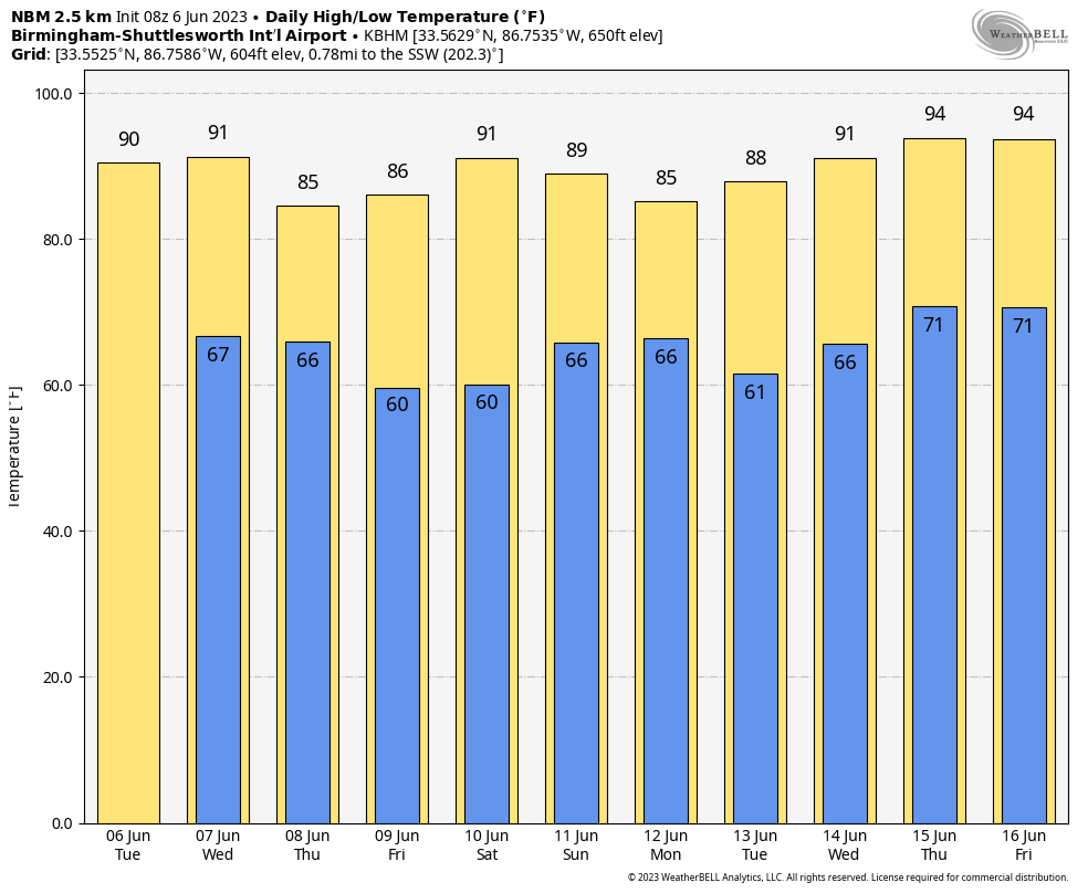
CLASSIC JUNE WEATHER: Alabama’s weather won’t change much through mid-week… partly to mostly sunny days, fair nights, and a few random, widely scattered afternoon and evening thunderstorms. The chance of any one spot seeing rain through Thursday is 15-25 percent, and most of the storms will form from 2:00 until 9:00 p.m. Afternoon highs will remain in the 87-91 degree range; the average high for Birmingham on June 6 is 87.
FRIDAY AND THE WEEKEND: An unusually dry airmass for summer will drop into Alabama Friday and Saturday. We expect sunshine in full supply both days with lower humidity and cooler nights. Highs will drop into the mid 80s, and many spots will see early morning lows in the 50s. Then, on Sunday, moisture levels rise and we will bring back the chance of scattered, mostly afternoon and evening showers and thunderstorms. Sunday’s high will be close to 90 degrees.
NEXT WEEK: At this point it looks like we will experience typical summer weather through the week with partly sunny days and the risk of random, scattered storms during the peak of the daytime heating process. Heat levels will rise, and we could see mid 90s over the latter half of the week. See the video briefing for maps, graphics, and more details.
TROPICS: A complex, non-tropical area of low pressure located between the Azores and Canary Islands is producing disorganized showers and thunderstorms with winds to gale force over the northeastern Atlantic Ocean. This system could acquire some subtropical characteristics during the next day or two while it meanders to the southeast and east of the Azores. By Thursday, the system is forecast to move northeastward over cooler waters and further development is not expected.
No tropical systems are expected anywhere near the U.S. through early next week.
ON THIS DATE IN 1816: The temperature reached 92 degrees at Salem, Massachusetts during an early heat wave, but then plunged 49 degrees in 24 hours to commence the famous “year without a summer.” Snow fell near Quebec City, Quebec Canada from the 6th through the 10th and accumulated up to a foot with “drifts reaching the axle trees of carriages.”
Evidence suggests that the anomaly was predominantly a volcanic winter event caused by the massive 1815 eruption of Mount Tambora in April in the Dutch East Indies (known today as Indonesia). This eruption was the largest in at least 1,300 years (after the hypothesized eruption causing the volcanic winter of 536); its effect in the climate may have been exacerbated by the 1814 eruption of Mayon in the Philippines.
ON THIS DATE IN 1944: Allied forces landed in northern France as part of a military action that paved the way for the defeat of Nazi Germany, molding the course of world history. Perhaps the most important weather forecast ever made was the one for D-Day.
On the evening of June 4, Captain James Martin Stagg, the highest ranking of the support meteorologists, convinced General Dwight D. Eisenhower to postpone the invasion by 24-hours. It was a decision that would prove crucial as the forecast ended up panning out. The weather on June 5 brought rough seas and 25-30 mph winds in the English Channel, but on June 6 the weather featured relatively clear skies and calm seas, which were necessary in order to make the invasion a successful one.
Look for the next video briefing here by 3:00 this afternoon… enjoy the day!
Category: Alabama's Weather, ALL POSTS, Weather Xtreme Videos
About the Author (Author Profile)
James Spann is one of the most recognized and trusted television meteorologists in the industry. He holds the AMS CCM designation and television seals from the AMS and NWA. He is a past winner of the Broadcast Meteorologist of the Year from both professional organizations.Subscribe
If you enjoyed this article, subscribe to receive more just like it.


