Storms Remain Isolated Through Tomorrow; Dry Air Rolls In Friday
JUST A FEW ISOLATED SHOWERS: We have just a few isolated showers and thunderstorms across Alabama this afternoon over the southern 2/3 of the state. Otherwise, the sky is partly too mostly sunny with temperatures in the 88-91 degree range for most places. The showers will end soon after sunset, and tonight will be mostly fair with a low in the 60s.
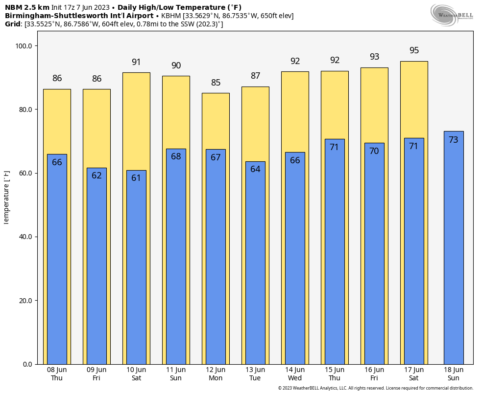
Heat levels begin to come down tomorrow as a surface front moves through the state, but storms remain isolated in coverage with many places remaining dry. The high tomorrow will be in the mid to upper 80s.
FRIDAY AND THE WEEKEND: An unusually dry airmass for June will drop into Alabama Friday and Saturday with lower humidity and cooler nights. Many places across the northern half of the state will dip into the 50s during the early morning hours. Moisture levels rise Sunday, and we will bring back the chance of scattered showers and thunderstorms. Highs will be in the 80s over the weekend.
NEXT WEEK: For now the weather looks fairly typical for early summer with partly sunny days and “scattered, mostly afternoon and evening showers and thunderstorms”. Heat levels will be creeping up, and some communities could reach the mid 90s toward the end of the week. See the video briefing for maps, graphics, and more details.
TROPICS: The Atlantic basin is quiet and tropical storm formation is not expected through next week.
WEATHER RELATED INJURY: An isolated storm blew a tree down onto a golf cart at the Trussville Country Club yesterday; one person sustained serious injuries. The same storm produced small hail and torrential rain.
ONE YEAR AGO TODAY: Several rounds of showers and thunderstorms occurred across Central Alabama from the afternoon of June 7 through the evening of June 8, 2022. This led to flash flooding, which became significant in areas of Etowah County, such as Gadsden and Glencoe, on the evening of June 7. Additional flash flooding occurred across portions of Jefferson, Shelby, and Talladega Counties during the early morning hours of June 8. Slow moving thunderstorms dumped upwards of 6″ of rain which led to significant flash flooding in areas such as Birmingham and Sylacauga.
Look for the next video update here by 6:00 a.m. tomorrow…
Category: Alabama's Weather, ALL POSTS, Weather Xtreme Videos
About the Author (Author Profile)
James Spann is one of the most recognized and trusted television meteorologists in the industry. He holds the AMS CCM designation and television seals from the AMS and NWA. He is a past winner of the Broadcast Meteorologist of the Year from both professional organizations.Subscribe
If you enjoyed this article, subscribe to receive more just like it.


