Storms For South Alabama This Evening; Statewide Tomorrow/Wednesday
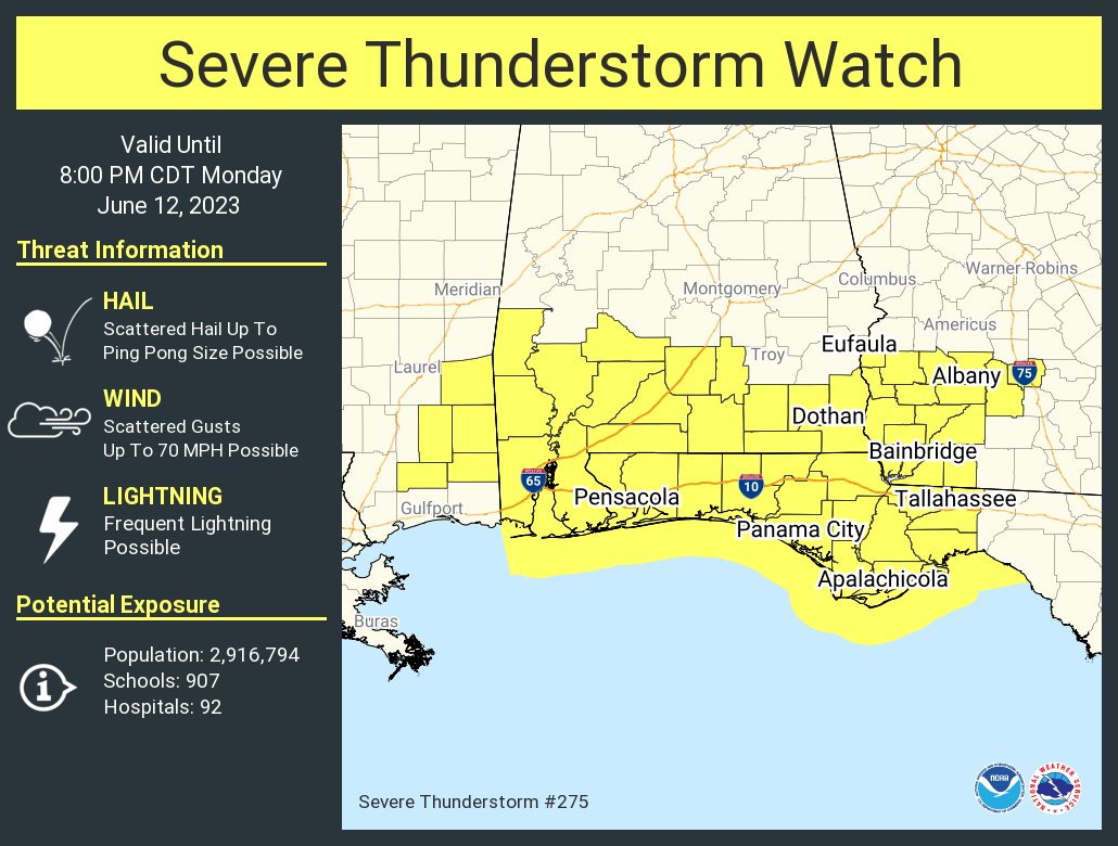
RADAR CHECK: Thunderstorms continue to increase across the southern half of Alabama at mid-afternoon… generally south of a line from Chatom to Montgomery to Opelika. A severe thunderstorm watch is in effect for South Alabama through 8:00 p.m… heavier storms will be capable of producing hail and strong winds.
Most of North Alabama will be dry tonight, north of a surface boundary draped across the central counties of the state.
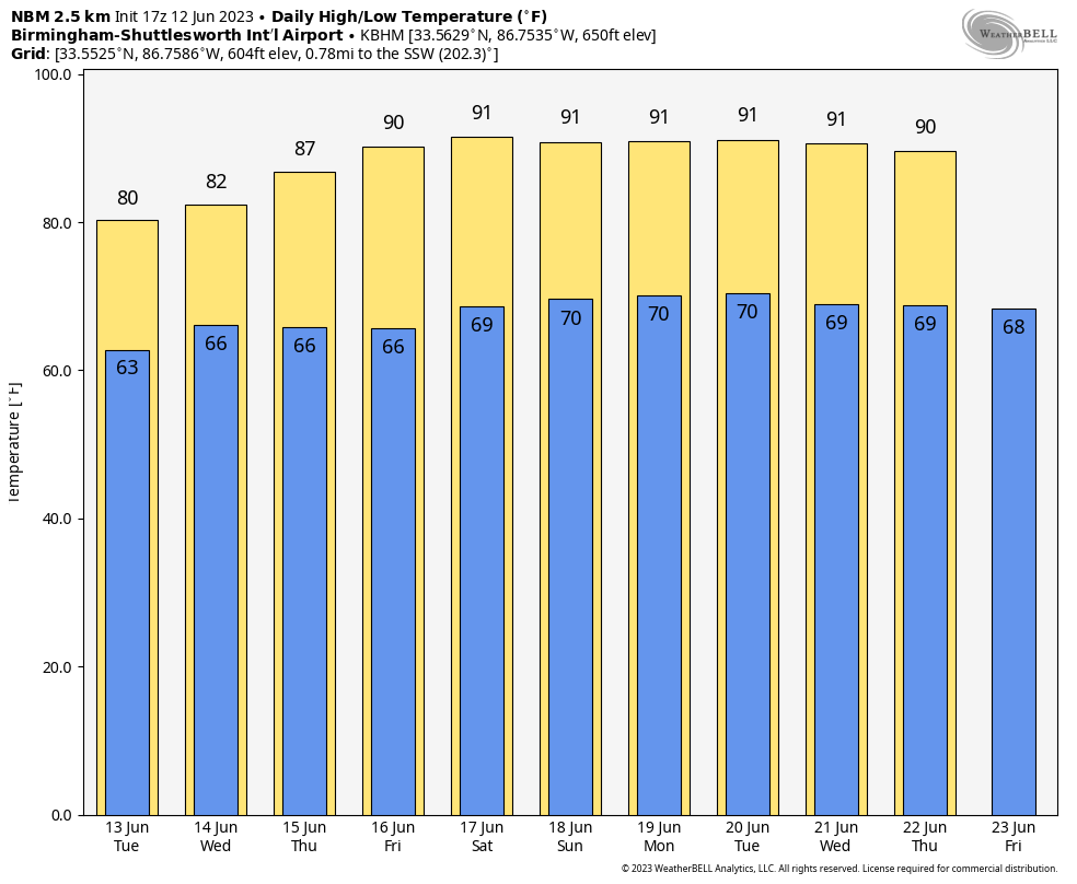
REST OF THE WEEK: We expect multiple rounds of thunderstorms across Alabama tomorrow through Thursday. Understand it certainly won’t rain all day, and the sun will be out at times. But, when the storms do form they could be strong. SPC has a large part of the state is a level 1 or 2 severe weather threat tomorrow and Wednesday due to the hail/wind potential. The sky will feature more clouds than sun each day, and highs will remain in the 80s.
Models suggest we will get a one day shot of drier air Friday; the day should be mostly sunny with a high around 90. Showers and storms on Friday will be confined to the far southern part of Alabama, and even there it won’t rain everywhere.
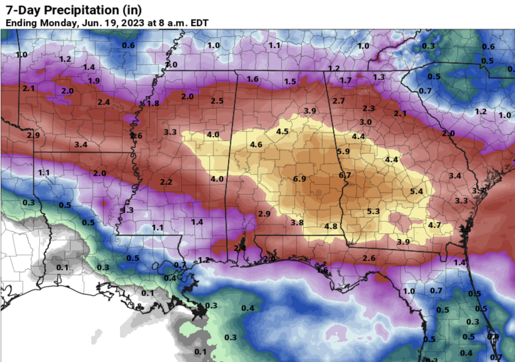
THE ALABAMA WEEKEND: Moist air returns along with the chance of showers and thunderstorms both days. Again, no “all day rain”, but a few passing showers and storms are a good possibility with afternoon highs in the 87-91 degree range. Rain amounts across Alabama between now and Sunday night will exceed 4 inches in spots.
NEXT WEEK: At this point it looks like we will have some fairly routine weather next week with partly sunny days along with “scattered, mostly afternoon and evening showers and thunderstorms”. Highs will be close to 90 degrees through the week… See the video briefing for maps, graphics, and more details.
TROPICS: The Atlantic basin remains quiet and tropical storm formation is not expected through the week.
ON THIS DATE IN 1915: An estimated F4 tornado moved northeast from northwest of Waterville, Iowa crossing the Mississippi River two miles south of Ferryville, Wisconsin. A man and his daughter were killed in one of three homes that were obliterated southwest of “Heytman,” a small railroad station on the Mississippi River. 60 buildings and eight homes were destroyed in Wisconsin.
Look for the next video briefing here by 6:00 a.m. tomorrow…
Category: Alabama's Weather, ALL POSTS, Weather Xtreme Videos
About the Author (Author Profile)
James Spann is one of the most recognized and trusted television meteorologists in the industry. He holds the AMS CCM designation and television seals from the AMS and NWA. He is a past winner of the Broadcast Meteorologist of the Year from both professional organizations.Subscribe
If you enjoyed this article, subscribe to receive more just like it.


