Several Rounds Of Strong Storms Likely Through Thursday
UNSETTLED PATTERN: Active weather is the story for Alabama through mid-week with multiple rounds of strong thunderstorms expected. Today SPC defines a “slight risk” (level 2/5) of severe thunderstorms for much of Central and South Alabama, with marginal risks (level 1/5) to the north and south.
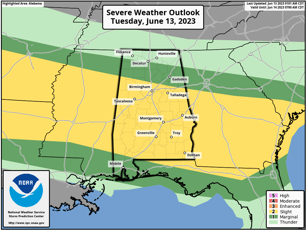
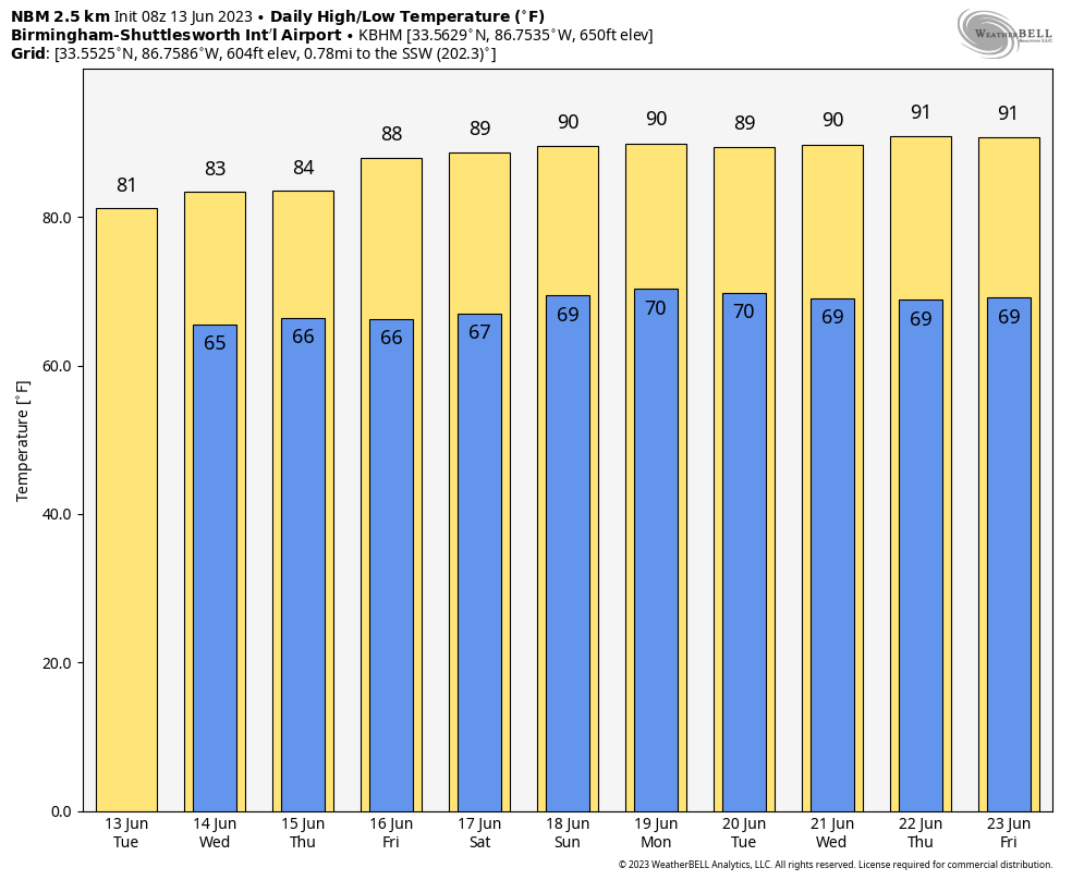
High resolution model suggest the most widespread rain today could very well come during the morning hours, and heavier storms will be capable of producing strong winds and some hail. The high today will be in the 80s for most places, with low 90s possible for the southern quarter of the state.
Tomorrow SPC has now defined an “enhanced risk” (level 3/5) for parts of Central and South Alabama, including cities like Demopolis, Selma, Montgomery, Greenville, Monroeville, Troy, and Eufaula. “Slight” and “marginal” risks surround the enhanced risk to cover much of the state.
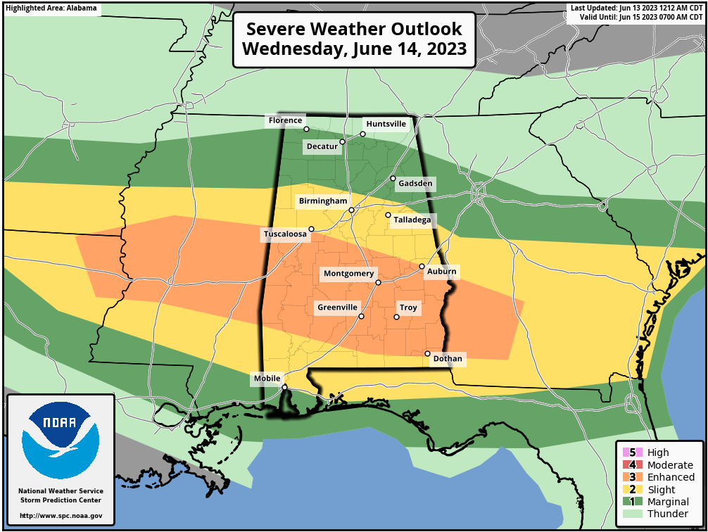
Hail and strong winds remain possible with the heavier thunderstorms tomorrow, and with unusually strong wind fields for June, an isolated tornado or two can’t be totally ruled out, especially in the enhanced risk area. This is very unusual for Alabama since typically we don’t see any chance of tornadoes here with thunderstorms in June (and the rest of summer) due to weak winds aloft. Highs will remain in the 80s for most places.
THURSDAY THROUGH THE WEEKEND: Scattered to numerous showers and storms are likely Thursday, but showers should thin out greatly Friday. We bring back scattered showers and storms into the forecast Friday night and through the weekend. Understand the weekend won’t be a wash-out, but from time to time expect a passing shower or thunderstorm. Highs will be in the 85-91 degree range Saturday and Sunday for most communities with some sun at times.
NEXT WEEK: A heat bubble will be focused to the west over Texas, and an upper low is forecast to be east of Alabama. This will bring some fairly typical summer weather to the state for much of the week with partly sunny days and “scattered, mostly afternoon and evening showers and thunderstorms”. Highs will be close to 90 on most days… See the video briefing for maps, graphics, and more details.
TROPICS: All remains quiet across the vast Atlantic basin, and tropical storm formation is not expected through the weekend.
ON THIS DATE IN 1972: Severe weather conditions over the Yucatan peninsula in Mexico begin to converge and form a tropical depression that would become Hurricane Agnes over the next two weeks. This hurricane affected most of the eastern United States with the Northeast being the hardest hit area with heavy rainfall.
ON THIS DATE IN 1976: A deadly tornado moved across parts of the southwestern Chicago, Illinois suburbs killing three people and injured 23 others. The tornado, with winds over 200 mph moved from Lemont to Downers Grove causing $13 million in damage when 87 homes were destroyed, and another 90 were damaged. The tornado passed over the Argonne National Laboratory, peeling part of a roof of the building housing a nuclear reactor.
Look for the next video briefing here by 3:00 this afternoon… enjoy the day!
Category: Alabama's Weather, ALL POSTS, Weather Xtreme Videos
About the Author (Author Profile)
James Spann is one of the most recognized and trusted television meteorologists in the industry. He holds the AMS CCM designation and television seals from the AMS and NWA. He is a past winner of the Broadcast Meteorologist of the Year from both professional organizations.Subscribe
If you enjoyed this article, subscribe to receive more just like it.


