Strong Storms Moving Through NW Alabama
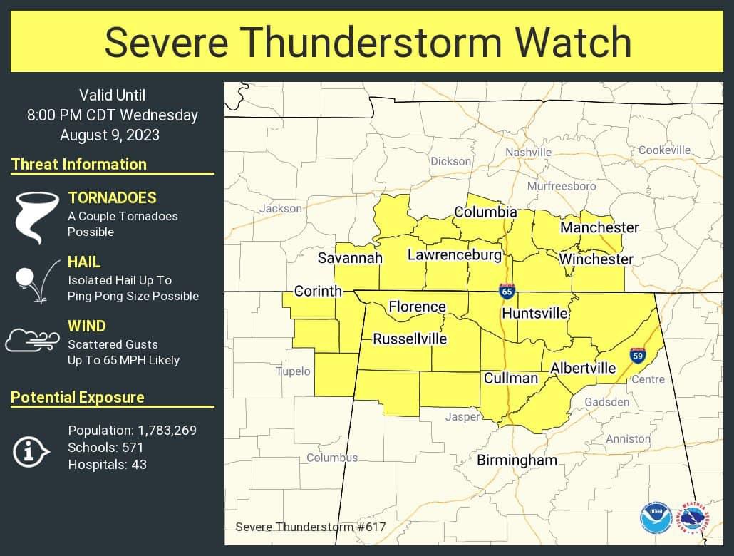
ACTIVE NIGHT FOR NORTH ALABAMA: A severe thunderstorm watch is in effect for roughly the northern quarter of Alabama through 8:00 p.m. A line of severe storms is moving through the Shoals as I write this around 2:45p CT, and as the storms continue moving through the Tennessee Valley they will be capable of producing strong/damaging winds.
We also note a few widely scattered storms over South Alabama at mid-afternoon in the hot, unstable air there.
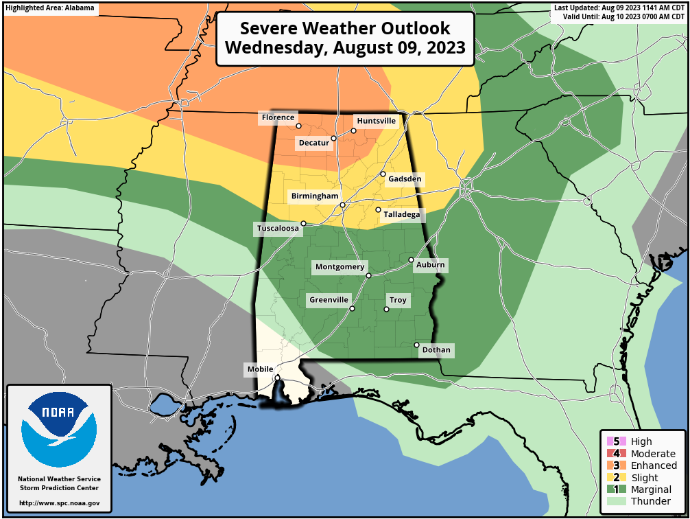
The initial batch of storms over the Tennessee Valley will move east of the state this evening, but high resolution models show another round of storms late tonight into the pre-dawn hours tomorrow; these storms will be capable of producing hail and strong winds as well. SPC maintains an “enhanced risk” (level 3/5) of severe thunderstorms north of a line from Hamilton to Cullman to Scottsboro tonight. There is a “slight risk” (level 2/5) down to Tuscaloosa, Calera, and Wedowee, and the rest of Central and much of South Alabama is in a “marginal risk” (level 1/5).
Be sure and pay attention to severe thunderstorm warnings as they are issued tonight.
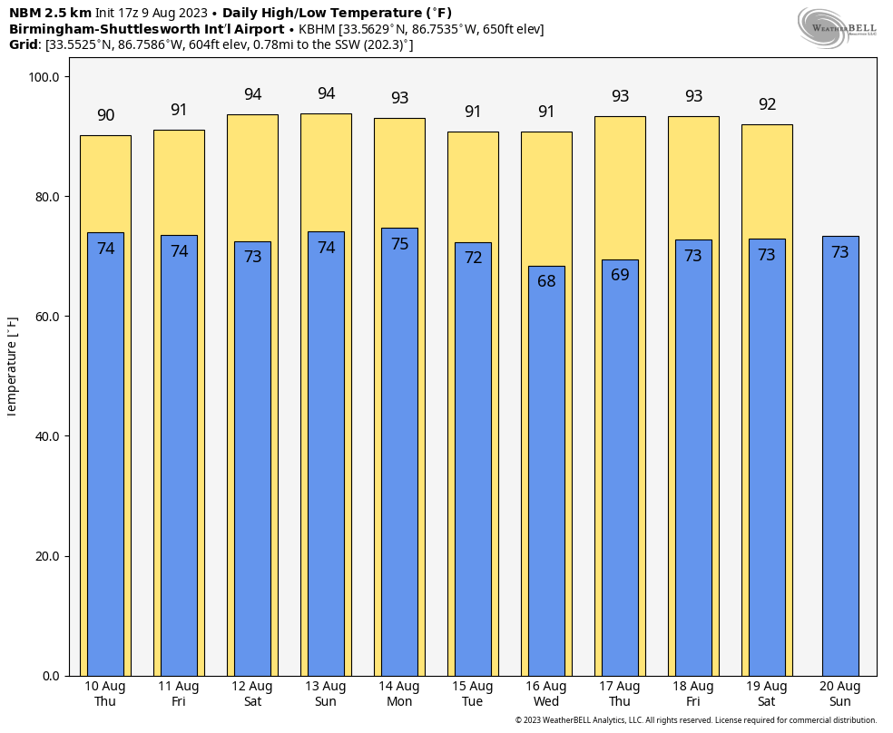
TOMORROW THROUGH THE WEEKEND: A few showers and storms will be around tomorrow, even during the morning hours. But, it won’t rain all day, and not everyone will see a storm. The high will be in the low 90s for most communities across the northern half of the state, with mid 90s for South Alabama.
We expect a mix of sun and clouds Friday through the weekend with the possibility of scattered showers and thunderstorms, most active during the afternoon and evening hours. The chance of any one spot getting wet daily is 45-55 percent, and highs will be in the 92-96 degree range for most communities.
NEXT WEEK: Some global models are hinting at drier air entering Alabama by Tuesday, suggesting drier days, slightly lower humidity levels, and cooler nights through mid-week. But, this doesn’t happen that often in August here, so we will “believe it when we see it”. Highs will remain mostly in the low to mid 90s… See the video briefing for maps, graphics, and more details.
TROPICS: Very calm conditions persist across the Atlantic basin, and tropical storm formation is not expected through at least the next seven days.
ON THIS DATE IN 1935: The temperature at Birmingham reached 104 degrees as a blistering heat wave continued. Temperatures exceeded 100 degrees for five consecutive days.
ON THIS DATE IN 1969: An F3 tornado hit Cincinnati, Ohio, killing four persons and causing fifteen million dollars property damage. The tornado moved in a southeasterly direction at 40 to 50 mph.
Look for the next video briefing here by 6:00 a.m. tomorrow…
Category: Alabama's Weather, ALL POSTS, WeatherBrains
About the Author (Author Profile)
James Spann is one of the most recognized and trusted television meteorologists in the industry. He holds the AMS CCM designation and television seals from the AMS and NWA. He is a past winner of the Broadcast Meteorologist of the Year from both professional organizations.Subscribe
If you enjoyed this article, subscribe to receive more just like it.


