A Few More Scattered Storms Later Today
RADAR CHECK: Noisy thunderstorms continue over parts of East and Central Alabama this morning around sunrise with heavy rain and gusty winds… some small hail is possible as well. Otherwise, it is a very muggy morning with temperatures in the 75-83 degree range.
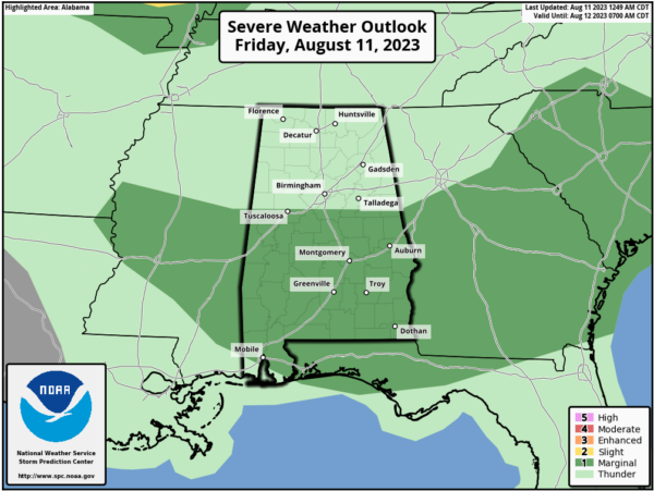
Additional storms will form in scattered spots by afternoon, and SPC maintains a “marginal risk” (level 1/5) of severe thunderstorms for areas south of a line from Tuscaloosa to Pelham to Lake Wedowee.
It won’t rain everywhere today, but where storms do form they will continue to have the potential for small hail and gusty winds. The high today will be in the 90-95 degree range for most communities.
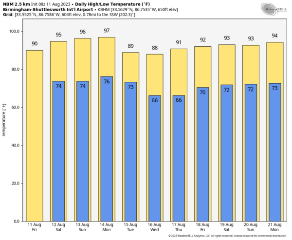
THE ALABAMA WEEKEND: Look for hot, humid weather tomorrow and Sunday with a mix of sun and clouds… afternoon temperatures will rise into the mid 90s. A few scattered showers and storms will around, mostly in the afternoon/evening hours in the noon-midnight window. Chance of any one spot getting wet both days is near 40 percent.
NEXT WEEK: A surface front will bring a risk of scattered storms Monday. Then, drier air will slip into the northern 2/3 of the state Tuesday through Thursday… this will mean lower humidity levels and cooler nights for a few days. Morning lows will dip into the low to mid 60s early Wednesday and Thursday morning for a hint of fall over the northern half of the state. The far southern counties will stay hot and humid, however. See the video briefing for maps, graphics, and more details.
TROPICS: The Atlantic basin remains very quiet, and tropical storm formation is not expected through at least the next seven days.
ON THIS DATE IN 1940: A Category 2 hurricane struck the Georgia and South Carolina coast. A 13-foot storm tide was measured along the South Carolina coast, while over 15 inches of rain fell across northern North Carolina. Significant flooding and landslides struck Georgia, North Carolina, Tennessee, and Virginia during the system’s slow trek as a weakening tropical storm, and then as an extratropical cyclone, through the Southeast. The landslides which struck North Carolina were considered a once in a century event.
ON THIS DATE IN 1999: An F2 tornado touched down in the metropolitan area of Salt Lake City. The tornado lasted ten minutes and killed one person, injured more than 80 people, and caused more than $170 million in damages. It was the most destructive tornado in Utah’s history and awakened the entire state’s population to the fact that the Beehive State does experience tornadoes.
Look for the next video update here by 3:00 this afternoon… enjoy the day!
Category: Alabama's Weather, ALL POSTS, Weather Xtreme Videos


