Showers/Storms Possible Across Alabama Again Today; Eyes On Idalia
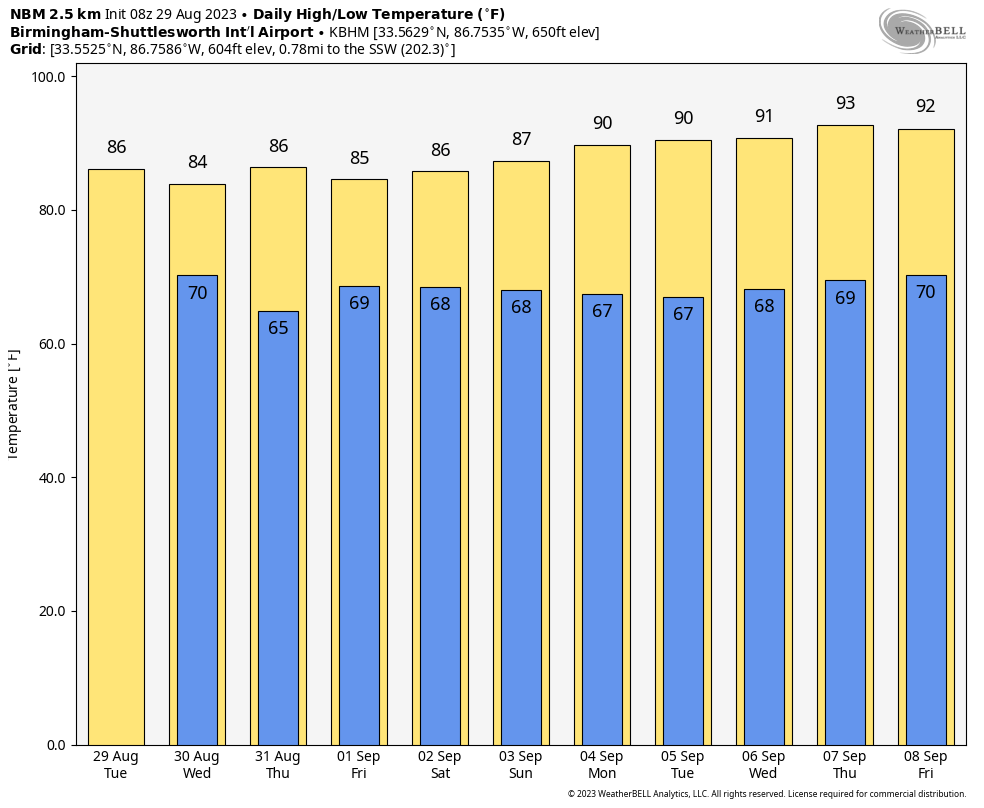
OCEAN OF HUMIDITY: Most of Alabama is dry early this morning, but we expect showers and storms to form again later today in the very humid air over Alabama. The chance of any one spot getting wet today is 40/50 percent, and like yesterday the storms will be very efficient rain producers. The sky will be occasionally cloudy, and the high will be in the mid to upper 80s over the northern counties, with low 90s to the south.
REST OF THE WEEK: The best chance of rain across Alabama tomorrow will be over the southeast counties of the state as Idalia passes to the east. Windy and showery conditions are likely from Eufaula to Dothan, but the significant impact of the hurricane will be well to the east. For the rest of the state, expect a mix of sun and clouds with highs in the 80s over North Alabama, with low 90s over the southern counties.
Thursday and Friday will be dry with sunny days, lower humidity, and cooler nights. Some of the cooler spots across North Alabama will dip into the 50s early Thursday morning. Highs will stay in the mid to upper 80s over the northern counties, with low 90s to the south.
LABOR DAY WEEKEND: Dry weather continues with mostly sunny days and fair nights through Monday. Highs for North Alabama will be in the 87-91 degree range, with low to mid 90s for the southern quarter of the state.
NEXT WEEK: The weather continues to look quiet through the rest of next week with only isolated afternoon showers as the upper ridge rebuilds; highs will be mostly in the low to mid 90s. See the video briefing for maps, graphics, and more details.
IDALIA BECOMES A HURRICANE: Hurricane Idalia, with winds of 75 mph, is about 370 miles south of Tampa this morning, and is moving to the north at 14 mph.
Some key points…
*The new NHC forecast is nudged a little to the west early this morning; landfall is now expected tomorrow morning on the Florida coast, in the “Big Bend” region southeast of Tallahassee.
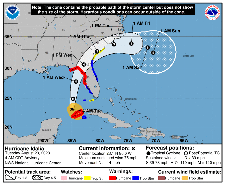
*A hurricane warning remains in effect from Indian Pass down to the middle of Longboat Key, including Tampa Bay.
*With an inner core now present, the stage is set for Idalia to rapidly intensify before landfall. Shear should continue to lower over the cyclone as an upper-level trough departs the northeastern Gulf of Mexico and ridging builds closer to the cyclone. These changes, combined with extremely warm and deep waters the hurricane will be traversing, all strongly point to rapid intensification. The new forecast is similar to the previous one, and confidence is increasing in an extremely dangerous major hurricane making landfall tomorrow morning along the Big Bend region of Florida.
*Remember, as you look at the forecast track, the main impact in terms of wind, rain, storm surge, flooding, and isolated tornadoes will be along and to the right (east) of the circulation center.
*There is a danger of life-threatening storm surge inundation along portions of the Florida Gulf Coast where a Storm Surge Warningis in effect, including Tampa Bay and the Big Bend region of Florida. Inundation of 8 to 12 feet above ground level is expected somewhere between Chassahowitzka and Aucilla River. Residents in these areas should follow any advice given by local officials.
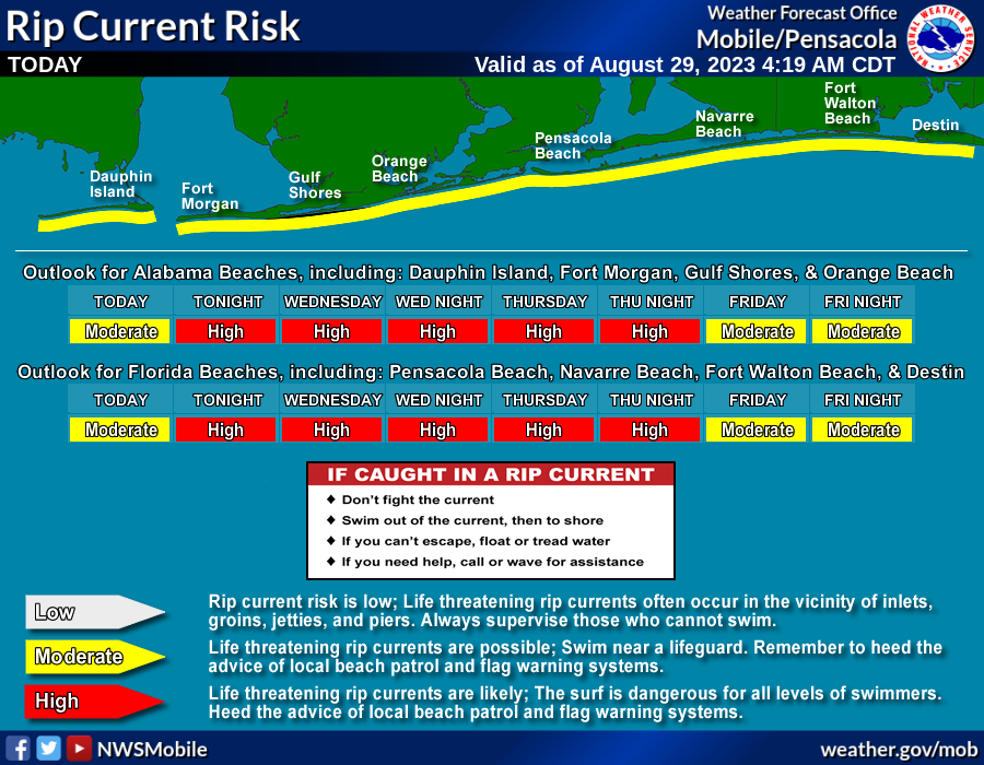
*Most of the Florida Panhandle will be on the “good” west side of the system with an offshore flow, but dangerous rip currents are likely through Thursday.
*Most of Alabama won’t see any rain directly associated with Idalia, but the southeast counties will see gusty winds and periods of rain tomorrow.
The forecast could change today, so as always watch for updates. When it comes to tropical systems, if you are working with old information, you are working with bad information.
FRANKLIN: Hurricane Franklin is in the Atlantic with winds of 140 mph…. it will pass west and north of Bermuda over the next 24 hours, then it heads into the North Atlantic where it will become post-tropical this weekend.
ON THIS DATE IN 2005: Hurricane Katrina made landfall as a category three storm over Southeast Louisiana and Mississippi. The majority of the loss of lives in Hurricane Katrina was due to flooding caused by fatal engineering flaws in the flood protection system, specifically the levee, around the city of New Orleans. Eventually, 80% of the city, as well as large areas in neighboring parishes, were flooded for weeks. The flooding also destroyed most of New Orleans’s transportation and communication facilities, leaving tens of thousands of people who did not evacuate the city prior to landfall with little access to food, shelter, and other basic necessities.
The coast of Mississippi suffered severe damage from wind and storm surge. The death toll was 1,836 as a direct result of Katrina.
Look for the next video briefing here by 3:00 this afternoon… enjoy the day!
Category: Alabama's Weather, ALL POSTS, Weather Xtreme Videos
About the Author (Author Profile)
James Spann is one of the most recognized and trusted television meteorologists in the industry. He holds the AMS CCM designation and television seals from the AMS and NWA. He is a past winner of the Broadcast Meteorologist of the Year from both professional organizations.Subscribe
If you enjoyed this article, subscribe to receive more just like it.


