Most Of Alabama Dry On This Labor Day
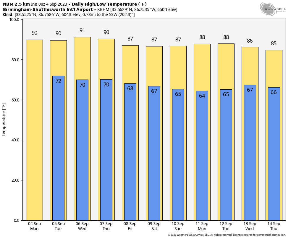
QUIET WEATHER PATTERN: Most of Alabama will be dry today; odds of any one spot getting a shower this afternoon are only 5-10 percent, and we generally don’t mention it in the forecast when the chance is that low. The sky will be partly too mostly sunny, and the high will be in the 87-92 degree range.
REST OF THE WEEK: Dry weather will continue tomorrow with a good supply of sunshine, but we will bring in some risk of scattered showers and thunderstorms Wednesday and Thursday as moisture levels rise ahead of a surface front. The chance of any one given spot seeing rain both days is 30-40 percent, and showers will be most active during the afternoon and evening hours. Then, on Friday, drier air pushes into the state, and the chance of showers will be generally confined to the southern counties south of Montgomery.
Highs will be in the low 90s for most places tomorrow and Wednesday, near 90 Thursday, and in the mid to upper 80s Friday.
THE ALABAMA WEEKEND: For now it looks dry for most of the state with mostly sunny days, fair nights, and highs in the 84-88 degree range. A few scattered showers will be possible near the Gulf Coast, but even there probably not much rain.
NEXT WEEK: Global models are suggesting the return of showers and storms toward the middle of the week with an upper trough approaching; highs will be mostly in the 80s. See the video briefing for maps, graphics, and more details.
TROPICS: Tropical Storm Gert, and Tropical Depression Katia are expected to dissipate far from land over the next 24 hours. The focus is on Invest 95L in the eastern Atlantic, which is forecast to become a significant hurricane in a few days on the journey across the Atlantic. Most of the long range global model ensemble members for now suggest it will turn north, and then head out to the North Atlantic before reaching the U.S. The name will be “Lee”.
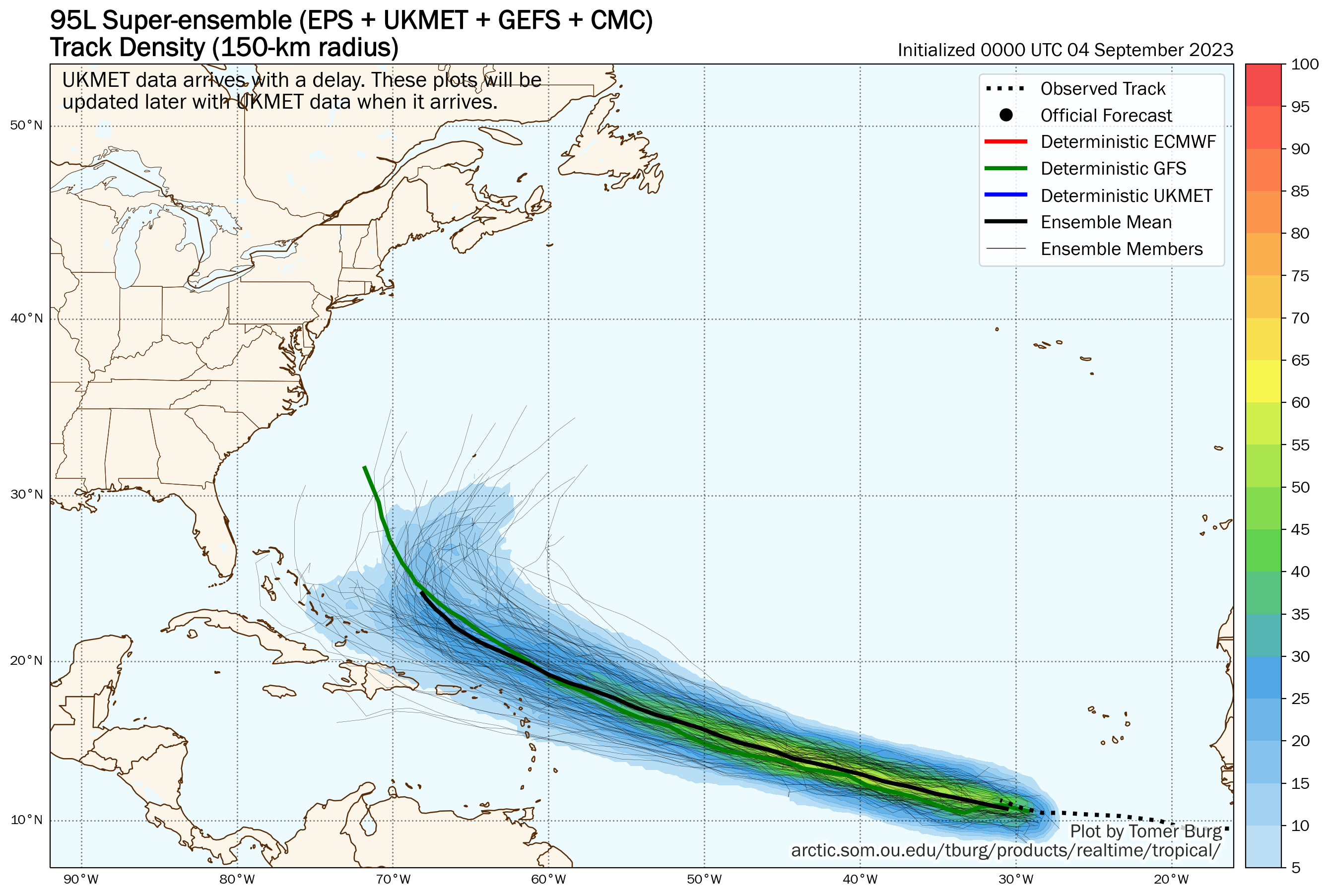
No tropical systems will threaten the U.S. or the Gulf of Mexico for the next seven days.
ON THIS DATE IN 1933: A category 3 hurricane made landfall on South Padre Island, Texas during the late evening hours on September 4th, or Labor Day. The storm caused 40 fatalities.
ON THIS DATE IN 1950: Hurricane Easy was an erratic and unpredictable hurricane that lingered over the Tampa Bay area for days, dropping torrential rains and causing damage especially in Cedar Key, Florida where the storm eventually made landfall. This hurricane dumped 38.7 inches of rain in 24 hours in Yankeetown, a record for the U.S. at the time
ON THIS DATE IN 1996: Hurricane Fran made landfall near the tip of Cape Fear, North Carolina with maximum sustained winds near 115 mph on the evening of September 5th. Fran was responsible for 26 deaths and was at the time the most expensive natural disaster ever in North Carolina’s history.
We are on a holiday schedule, so just one video briefing today, but I will post fresh forecast notes here this afternoon. Enjoy the day!
Category: Alabama's Weather, ALL POSTS, Weather Xtreme Videos
About the Author (Author Profile)
James Spann is one of the most recognized and trusted television meteorologists in the industry. He holds the AMS CCM designation and television seals from the AMS and NWA. He is a past winner of the Broadcast Meteorologist of the Year from both professional organizations.Subscribe
If you enjoyed this article, subscribe to receive more just like it.


