Showers Are Few And Far Between Across Alabama Today
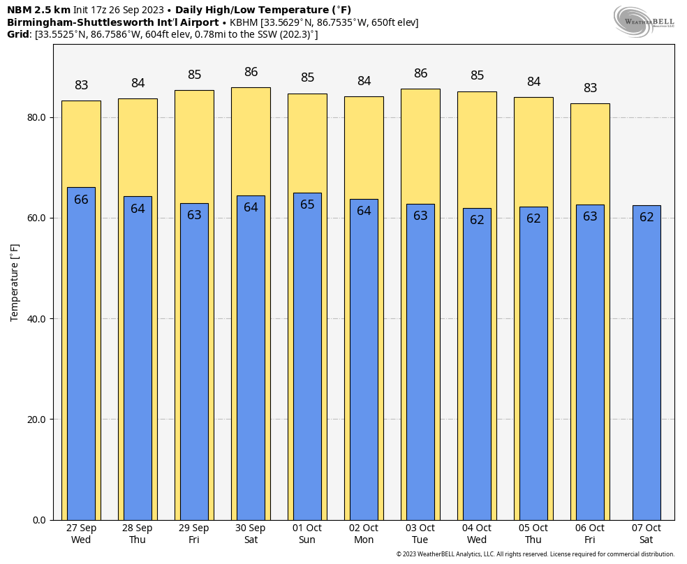
WARM SEPTEMBER AFTERNOON: Temperatures are generally in the 86-91 degree range across Alabama this afternoon… the exception is Mobile where they have soared to 94 degrees at mid-afternoon. Most of the showers on radar area across the southeast counties of the state, in areas generally east and south of Montgomery. A few small, isolated showers are forming elsewhere, but most places are dry with a partly sunny sky. We will hang on to some risk of isolated showers tonight; the low will be in the 60s for most places.

The weather won’t change much tomorrow; a few widely scattered showers or storms are possible, mainly over the southern half of the state. Otherwise we expect a mix of sun and clouds with a high in the mid to upper 80s for most communities.
THURSDAY THROUGH THE WEEKEND: An upper ridge begins to rebuild, and the weather looks dry for most of Alabama Thursday through Sunday with mostly sunny warm days and fair pleasant nights. Highs will remain in the 80s, with lows in the 60s.
NEXT WEEK: Not much change; a ridge will likely keep much of Alabama and the Deep South dry through the week with highs in the 80s. A few isolated showers could show up toward the end of the week as moisture levels rise, but the prospect of a big rain event is looking low for at least the next ten days. See the video briefing for maps, graphics, and more details.
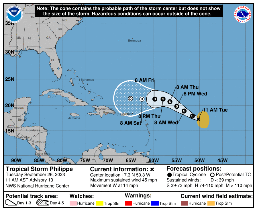
TROPICS: Tropical Storm Philippe remains disorganized this afternoon with winds of 45 mph. It is about 840 miles east of the Northern Leeward islands, moving west/northwest at 14 mph. The system will be encountering dry air and shear, and NHC is forecasting the system to weaken and become a remnant low this weekend well north of Puerto Rico.
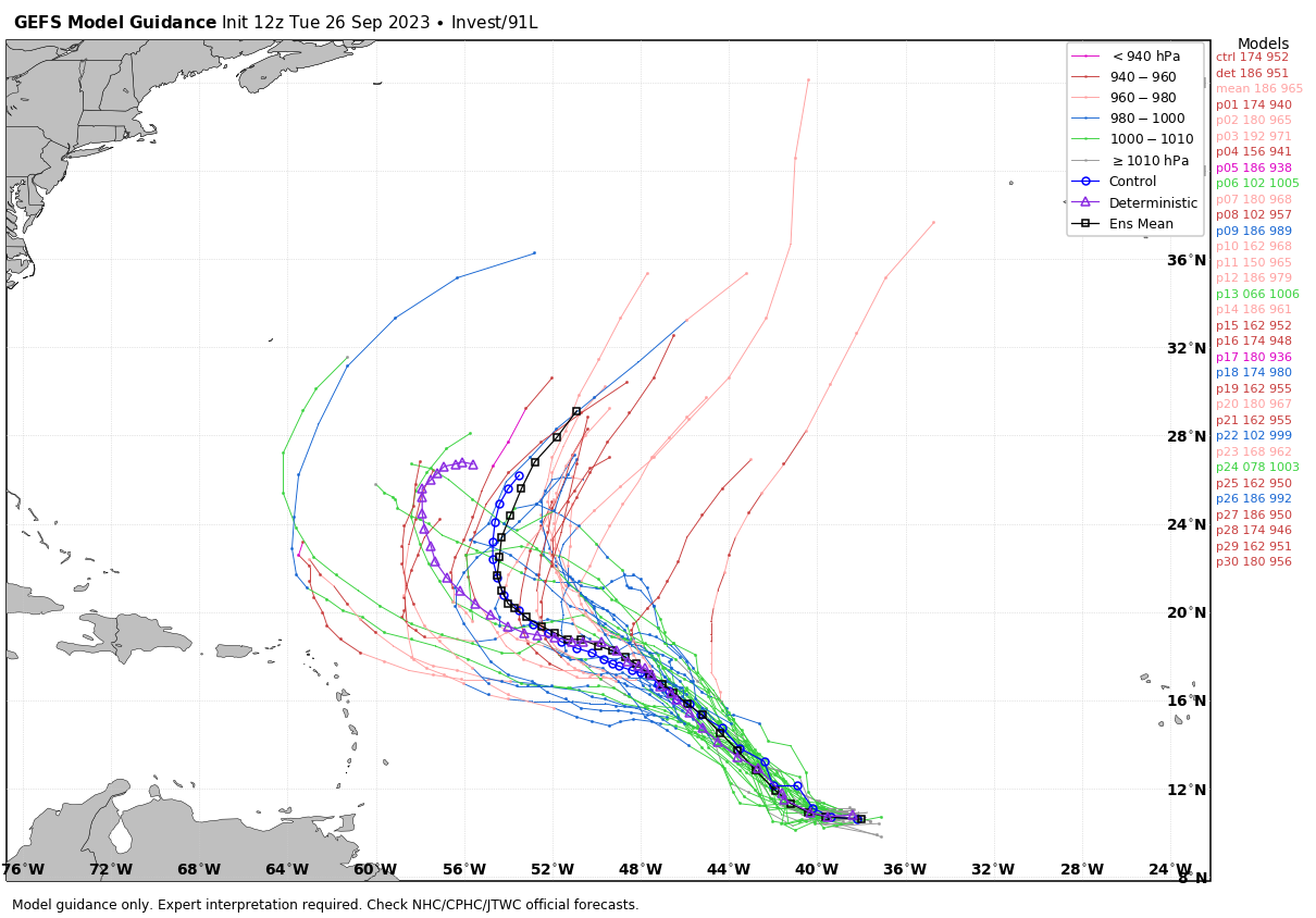
A tropical wave, Invest 91L, is trailing Philippe in the Atlantic. It is expected to become Tropical Storm Rina over the next few days, but it will turn north and is no threat to land.
No tropical systems will threaten the Gulf of Mexico for at least the next seven days.
RAIN UPDATE: Here are rain totals for the year so far, and the departure from average…
Muscle Shoals 35.24″ (-5.31″)
Huntsville 36.74″ (-3.24″)
Dothan 36.94″ (-5.07″)
Montgomery 39.58″ (+0.74″)
Tuscaloosa 41.23″ (+1.36″)
Anniston 41.73″ (+2.53″)
Birmingham 42.80″ (-0.72″)
Mobile 44.40″ (-7.81″)
ON THIS DATE IN 1898: A school teacher saved 32 children from death in Merritton, Ontario, when she spotted an approaching tornado and led her students to a safe corner. Unfortunately, falling debris killed one of the children and injured several others.
ON THIS DATE IN 1955: On this date, the Atlantic reconnaissance aircraft, ”Snowcloud Five” went down while investigating Hurricane Janet and was never heard from again. Lt. Comdr. Windham with a crew of 8 and two newspapermen reported that they were about to begin penetrating the central core of the hurricane. Hurricane Janet made landfall at peak intensity near Chetumal, Mexico on September 29th. Janet’s landfall as a Category 5 hurricane on the Yucatán Peninsula was the first recorded instance that a storm of such intensity in the Atlantic made landfall on a continental mainland; prior to Janet, landfalls of Category 5 intensity were only known to have taken place on islands.
Look for the next video briefing here by 6:00 a.m. tomorrow…
Category: Alabama's Weather, ALL POSTS, Weather Xtreme Videos
About the Author (Author Profile)
James Spann is one of the most recognized and trusted television meteorologists in the industry. He holds the AMS CCM designation and television seals from the AMS and NWA. He is a past winner of the Broadcast Meteorologist of the Year from both professional organizations.Subscribe
If you enjoyed this article, subscribe to receive more just like it.


