Rain Returns To Alabama Wednesday
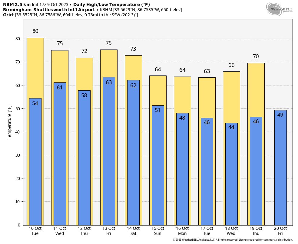
BLUE SKY: We are enjoying sunshine in full supply across Alabama this afternoon with low humidity along with temperatures in the 70s. Tonight will be clear with a low in the 45-55 degree range for most places.
Tomorrow will be another mostly sunny day with a high around 80 degrees.
WEDNESDAY: A disturbance loaded with tropical moisture, partly from Lidia (expected to be a hurricane when it moves into Mexico from the eastern Pacific tomorrow night), will bring a beneficial rain event to South Alabama. The most widespread and heaviest rain will be south of U.S. 80 (Demopolis to Montgomery to Opelika), where 1-3 inches are likely. Models are trending northward with the extent of the rain, and it now looks like some rain could fall as far north as the Tennessee Valley. Rain amounts over. North Alabama will be generally under 1/2 inch.
Thursday will be a dry with a partly sunny sky; the high will be in the 70s for most places.
FRIDAY AND THE WEEKEND: An approaching cold front will bring a chance of showers statewide Friday and Friday night. Unfortunately it looks like rain amounts will be rather light and spotty with limited moisture available. Then, the sky will clear Saturday morning, and Sunday will feature sunshine in fully supply. The high Saturday will be in the 70-75 degree range, then dropping into the 60s Sunday.
NEXT WEEK: For now most of the week looks dry with sunny pleasant days and clear cool nights; highs will be mostly in the 60s with lows in the 40s. See the video briefing for maps, graphics, and more details.
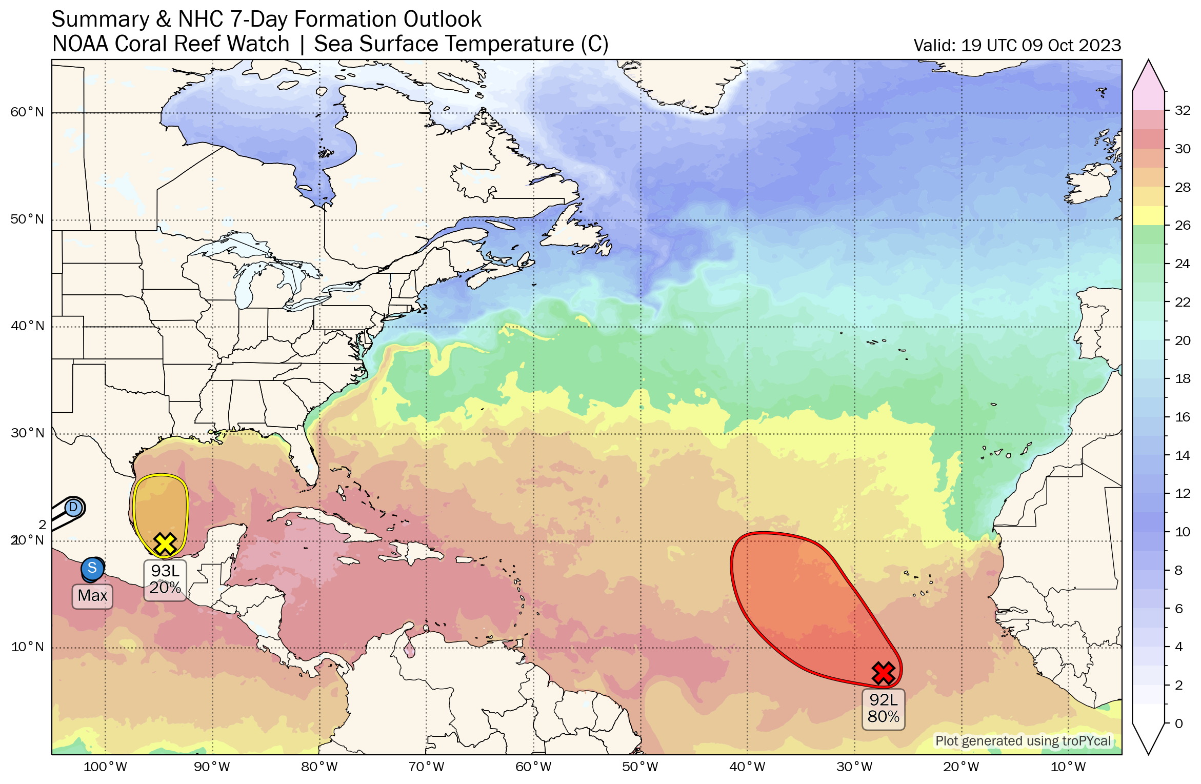
TROPICS: Shower and thunderstorm activity has changed little in organization in association with a small area of low pressure over the southwestern Gulf of Mexico. Environmental conditions appear only marginally favorable for some additional development while the system moves slowly northward before the low merges with a frontal system over the western Gulf of Mexico by midweek. NHC gives the system a 20 percent chance of development.
And, A low-latitude tropical wave located several hundred miles south-southwest of the Cabo Verde Islands continues to produce a large area of showers and thunderstorms. This activity has become a bit more concentrated this afternoon, and environmental conditions appear conducive for additional development of this system during the next several days. A tropical depression is likely to form in the next couple of days while it moves west-northwestward or northwestward across the eastern tropical Atlantic. This feature will likely turn northward, and will be no threat to the Lesser Antilles or the U.S. NHC gives it an 80 percent chance of development.
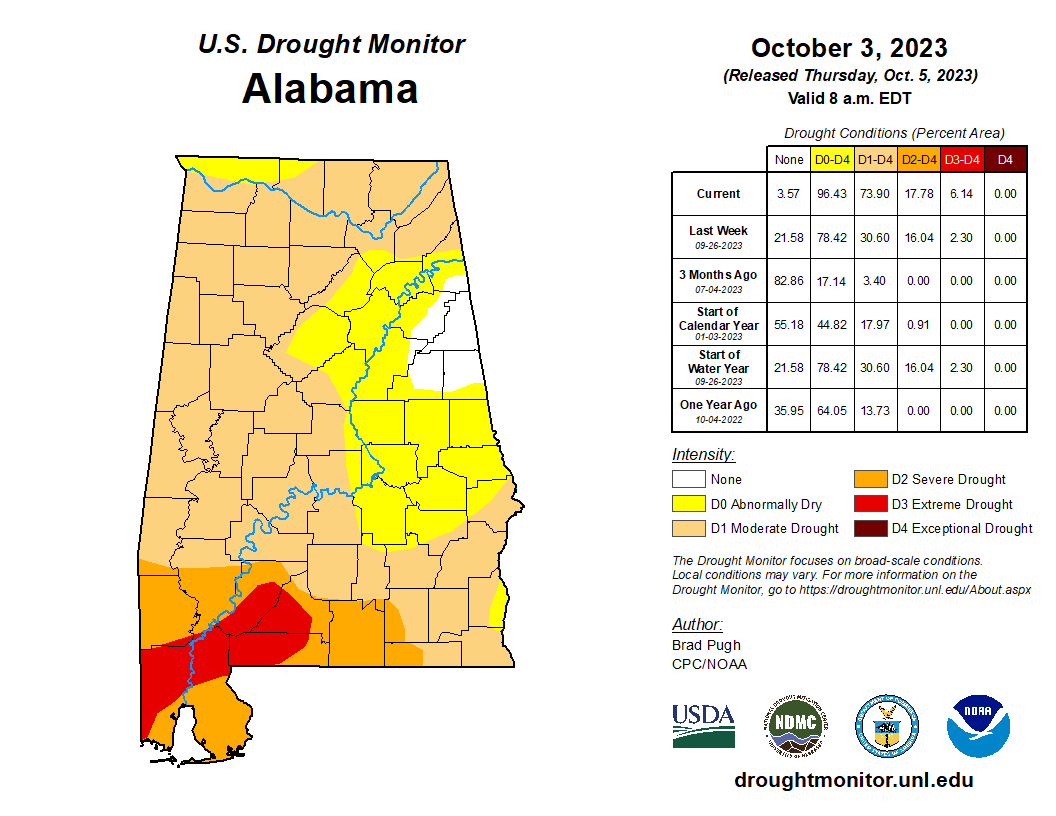
DROUGHT MONITOR: Parts of Southwest Alabama are in an “extreme drought” (D4)… a “severe drought” (D3) covers much of North, West, and South Alabama. Conditions are not as bad over the eastern counties, but conditions there are “abnormally dry” (D0).
The Alabama Forestry Commission maintains a “fire alert” for the entire state. Permits for outdoor burning will no longer be issued until further notice. Anyone burning a field, grassland, or woodland without a burn permit may be subject to prosecution for committing a Class B misdemeanor.
ON THIS DATE IN 1804: The famous Snow Hurricane moved ashore near Atlantic City on this day. After briefly passing through Connecticut and into Massachusetts, cold air was entrained in the circulation with heavy snow falling between New York to southern Canada. Berkshires Massachusetts and Concord New Hampshire record two feet of snow with this hurricane. This storm produced the first observation of snow from a hurricane, but not the last. Hurricane Ginny of 1963 brought up to 18 inches of snow to portions of Maine.
ON THIS DATE IN 2001: An unusually strong fall outbreak of tornadoes spawned at least 23 twisters across parts of Nebraska and Oklahoma. Hardest hit was the town of Cordell, OK, but a 22 minute lead time led to an amazingly low casualty count: only nine injuries and no fatalities.
Look for the next video briefing here by 6:00 a.m. tomorrow…
Category: Alabama's Weather, ALL POSTS, Weather Xtreme Videos
About the Author (Author Profile)
James Spann is one of the most recognized and trusted television meteorologists in the industry. He holds the AMS CCM designation and television seals from the AMS and NWA. He is a past winner of the Broadcast Meteorologist of the Year from both professional organizations.Subscribe
If you enjoyed this article, subscribe to receive more just like it.


