Freeze Warning For Wednesday Morning
TEMPS KEEP DROPPING: As advertised, temperatures continue to fall across the northern half of Alabama this afternoon in the wake of a sharp cold front, which is bringing the coldest air so far this season to the Deep South. Areas northwest of Birmingham are in the 40s at 3p CT, but south of the front temperatures are mostly in the 70s and low 80s. The sky is generally cloudy, and a few sprinkles continue in the cold air over North Alabama.
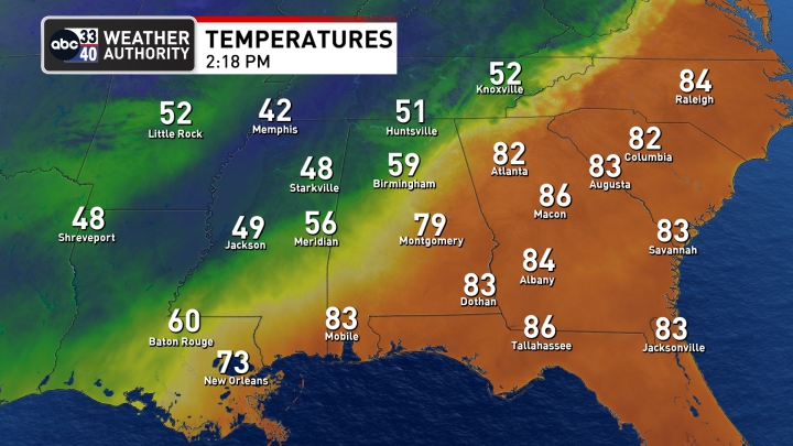
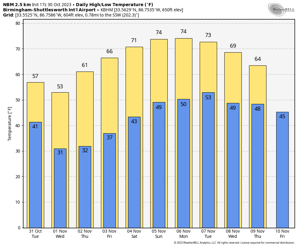
All of Alabama will be in the cold air tomorrow and Wednesday with highs in the 50s over the northern and central counties of the state, with low 60s to the south. A freeze warning has been issued for the northern half of Alabama for Wednesday morning… we expect lows in the 25-34 degree range with a clear sky and diminishing wind. Temperatures will drop into the upper 30s as far south as I-10 in far South Alabama. Thursday morning should be just as cold.
A warming trend begins Thursday afternoon, and by Friday highs will range from the 60s over North Alabama, to the low to mid 70s over the southern counties.
Other than the chance of patchy light rain today over the northern counties, the week will be dry. Lingering clouds will move out tomorrow morning, followed by sunny days and fair nights.
THE ALABAMA WEEKEND: The weekend will be dry with mostly sunny pleasant days and fair cool nights. Highs mostly in the 70s, lows in the 40s and 50s.
NEXT WEEK: Global models are now suggesting a disturbance will have potential to bring some rain into Alabama Monday night and Tuesday night of next week, but amounts will likely be light (1/2 inch or less). Another surge of cool, dry air arrives over the latter half of the week. See the video briefing for maps, graphics, and more details.
RED FLAG WARNING: A Red Flag Warning has been issued for much of Alabama tomorrow. The combination of a dry air mass and windy conditions will result in critical fire weather conditions. No outdoor burning.
TROPICS: An area of low pressure (Invest 96L) with associated disorganized showers is located about 100 miles east of the northwestern Bahamas. This system is moving into an area of strong upper-level winds and dry air, and the chances of it becoming a short-lived tropical storm are decreasing. The low is expected to move slowly northwestward today and then turn northward and northeastward tomorrow and Wednesday. The chance of development has dropped to 10 percent.
And, a trough of low pressure over the eastern Caribbean Sea is producing disorganized showers and thunderstorms. This system is expected to move westward during the next several days, and environmental conditions appear conducive for gradual development. A tropical depression could form late this week when the system reaches the central or southwestern Caribbean Sea. NHC gives it a 60 percent chance of development over the next seven days; it is headed for Central America.
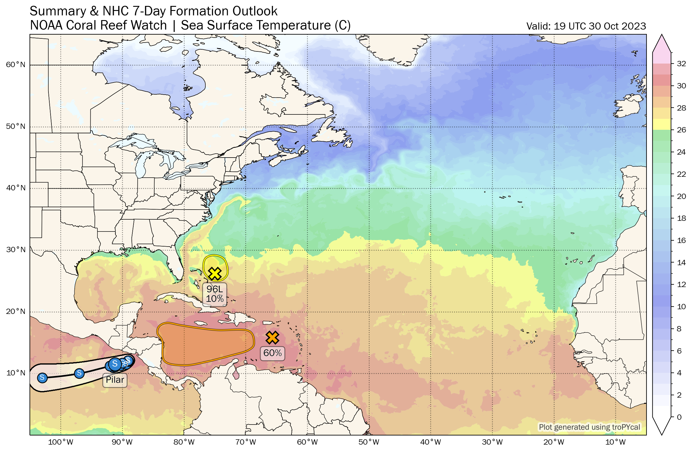
No tropical systems are expected near the U.S. or the Gulf of Mexico for the next seven days.
ON THIS DATE IN 1991: The Perfect Storm, also known as the No-Name Storm reached maximum strength on this day with a low pressure of 972 mb and sustained winds of 69 mph. Damage from the storm totaled over $200 million and thirteen people were killed in total, six of which were an outcome of the sinking of Andrea Gail, which inspired the book and later movie, The Perfect Storm.
Look for the next video briefing here by 6:00 a.m. tomorrow…
Category: Alabama's Weather, ALL POSTS, Weather Xtreme Videos
About the Author (Author Profile)
James Spann is one of the most recognized and trusted television meteorologists in the industry. He holds the AMS CCM designation and television seals from the AMS and NWA. He is a past winner of the Broadcast Meteorologist of the Year from both professional organizations.Subscribe
If you enjoyed this article, subscribe to receive more just like it.


