Warm, Dry Weather Through Mid-Week; Rain Returns By Friday
STILL DRY: Drought conditions continue to intensify across Alabama. Here is a look at rain totals since September 1, and the departure from average…
Muscle Shoals 0.44″ (-7.17″)
Tuscaloosa 1.64″ (-5.99″)
Huntsville 1.65″ (-6.02″)
Birmingham 2.23″ (-5.76″)
Mobile 3.46″ (-6.58″)
Anniston 3.68″ (-3.38″)
Dothan 3.74″ (-2.79″)
Montgomery 5.88″ (-1.25″)
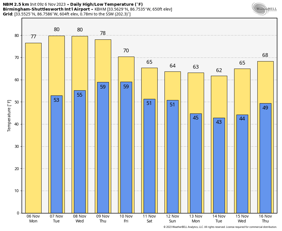
Dry weather continues through Wednesday with mostly sunny warm afternoons and fair cool nights.
RAIN RETURNS: Clouds will increase Thursday ahead of a cold front, and we will bring a good chance of light rain at times Thursday night and Friday. This won’t be a “drought buster”, but amounts of around 1/2 inch are likely statewide. The high Friday will drop into the 67-72 degree range.
THE ALABAMA WEEKEND: The front will become nearly stationary along the Gulf Coast Saturday, and there is some chance some rain could linger over the weekend, most likely over the southern half of the state. The weather will be cool with highs in the 60s and lows in the upper 40s and low 50s… the sky will be generally cloudy both days.
NEXT WEEK: For now the week looks generally dry with seasonal temperatures (highs mostly in the 60s, and lows in the 40s). Global models show evidence of the next rain event in the November 19-22 time frame). See the video briefing for maps, graphics, and more details.
TROPICS: All is quiet across the Atlantic basin, and tropical storm formation is not expected through the next five days.
ON THIS DATE IN 1961: Santa Ana winds in southern California downed trees, utility lines and blew 10 to 50 percent of the avocado crop from trees. Dust from the winds lowered the visibility, which led to a 16 car pileup, injuring 23 people. In addition, the winds brought the lowerest relative humidity of record to Burbank, 3 percent, and contributed to disastrous fires in the hills of the Los Angeles area.
ON THIS DATE IN 1977: Several possible causes lead to the collapse of the Kelly Barnes Dam in Georgia to give way. The failure allowed a 40-acre lake to flood the Toccoa Falls College, killing 39 people and injuring 60 more
ON THIS DATE IN 2005: The deadliest tornado to strike Indiana since April 3rd, 1974, occurred around 2 am. A single F3 tornado inflicted 24 fatalities, 238 injuries, and nearly 90 million dollars in damage with a path length of 41 miles. This storm moved in a northeasterly direction from just north of Smith Mills, Kentucky, to Gentryville, Indiana, and crossed the Ohio River three times. Most of the damage occurred as the tornado passed southeast of the city of Evansville, Indiana.
Look for the next video briefing here by 3:00 this afternoon… enjoy the day!
Category: Alabama's Weather, ALL POSTS, Weather Xtreme Videos
About the Author (Author Profile)
James Spann is one of the most recognized and trusted television meteorologists in the industry. He holds the AMS CCM designation and television seals from the AMS and NWA. He is a past winner of the Broadcast Meteorologist of the Year from both professional organizations.Subscribe
If you enjoyed this article, subscribe to receive more just like it.


