Wind/Rain For All Of Alabama Tonight; Severe Storms Near The Gulf Coast
RADAR CHECK: Rain continues to increase across Alabama this afternoon ahead of a dynamic weather system that will bring a variety of threats tonight and tomorrow morning.
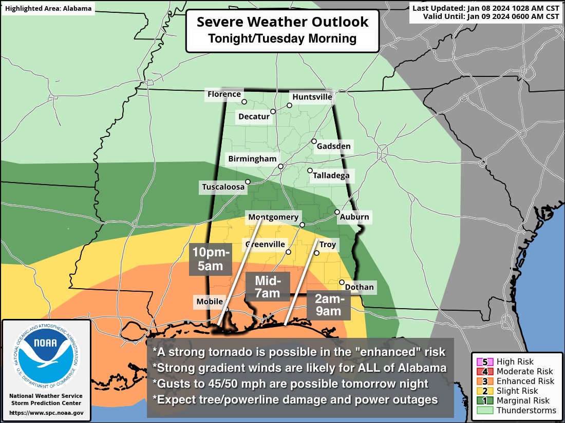
WIND: Gradient winds (not related to thunderstorms) will gust to 45/50 mph in spots statewide through early tomorrow morning. The highest winds will come from around 8:00 this evening through 6:00 a.m. tomorrow. This will bring potential for downed trees and power outages. A high wind warning has been issued for southern Mobile and Baldwin counties; a wind advisory is in effect for the rest of Alabama.
SEVERE STORMS: The main threat of severe thunderstorms is in the “enhanced risk” (level 3/5) area of South Alabama late tonight into tomorrow morning. A strong tornado (EF-2 or higher) is initially possible across Mobile, Baldwin, Washington, Escambia, and Covington counties, and then eastward into Coffee, Geneva, Houston, Henry, and Barbour counties in the 4:00 to 9:00 a.m. time frame tomorrow.
Those of you in South Alabama, especially south of a line from Millry to Evergreen to Abbeville, need to be sure you have a reliable way of hearing warnings in the middle of the night tonight. NEVER an outdoor siren. Preferred method is a NOAA Weather Radio. Be sure your smart phone is not in “do not disturb” mode.
The risk of severe storms north of the line from Millry to Evergreen to Abbeville is limited due to the lack of surface based instability. The northern half of Alabama will just see rain.
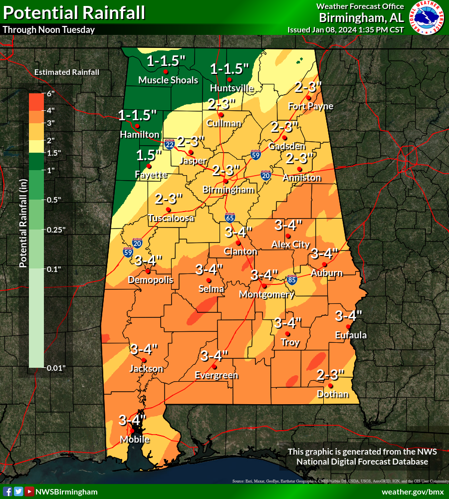
RAIN: Rain amounts of 2-3 inches are likely tomorrow through Tuesday, and some flooding issues are possible.
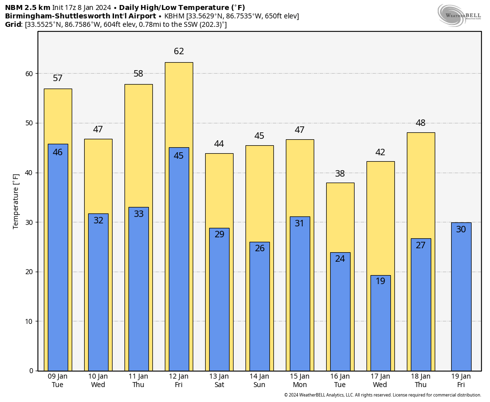
Rain tapers off statewide tomorrow morning; the day will be mostly cloudy and still windy with gusts to 30 mph possible during the afternoon hours. Temperatures will likely fall through the 40s over the northern 2/3 of the state as colder air arrives.
WEDNESDAY/THURSDAY: Dry weather is the story on these two days with highs in the 50s and 60s.
FRIDAY: Yet another dynamic system will bring more wind and rain to Alabama. SPC has the southern 2/3 of the state in a severe weather risk; it looks like unstable air will extend farther north into the state for this event.
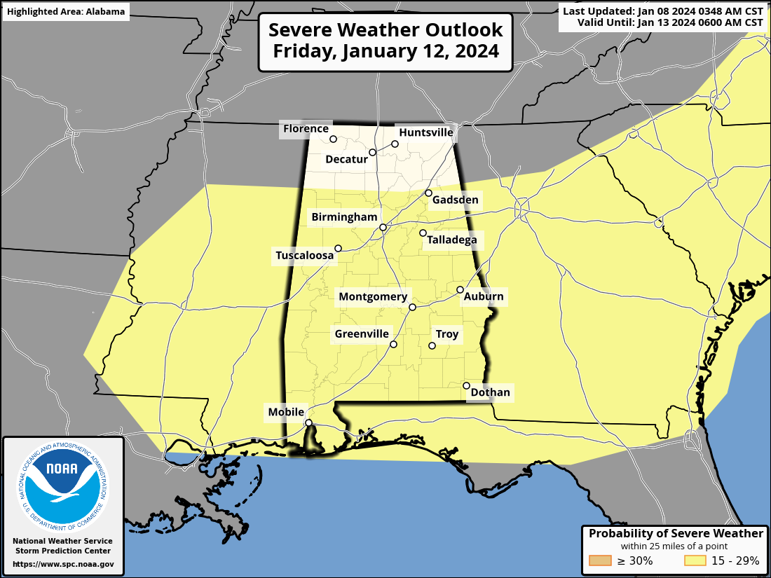
Gradient winds will also be strong Friday, and rain amounts of 1-2 inches are likely.
THE ALABAMA WEEKEND: Saturday will be windy and sharply colder; temperatures will likely hold in the 30s over the northern quarter of Alabama, with 40s to the south. Temperatures should be well below freezing by Sunday morning. The weekend will be dry.
NEXT WEEK: Global models are suggesting a weather system has potential to bring some “winter mischief” to parts of Alabama Monday (freezing rain or snow). But understand this will change multiple times over the next few days, and confidence in any specific outcome is very low. However, confidence is high the coldest air so far this winter season will roll into Alabama by Tuesday and Wednesday. This could get many places in the teens over the northern half of the state. See the video briefing for maps, graphics, and more details.
ON THIS DATE IN 1988: 9.6 inches was snow was on the ground at Huntsville following a big winter storm.
ON THIS DATE IN 2019: A tornado impacted Cortland, Ohio, during the mid-morning hours. The EF-1 tornado developed northeast of Champion Township in Trumbull County and moved east. The tornado brought down numerous trees and wires along the 4.5-mile path.
Look for the next video briefing here by 6:00 a.m. tomorrow…
Category: Alabama's Weather, ALL POSTS, Weather Xtreme Videos
About the Author (Author Profile)
James Spann is one of the most recognized and trusted television meteorologists in the industry. He holds the AMS CCM designation and television seals from the AMS and NWA. He is a past winner of the Broadcast Meteorologist of the Year from both professional organizations.Subscribe
If you enjoyed this article, subscribe to receive more just like it.


