Severe Storms Possible Tomorrow; Arctic Blast Arrives Next Week
DRY TODAY: With a partly to mostly sunny sky, we project a high in the 60-65 degree range for much of Alabama this afternoon. A very pleasant winter day. Clouds will move in tonight ahead of a dynamic storm system.
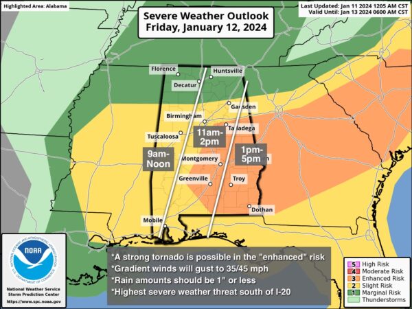
SEVERE STORMS POSSIBLE TOMORROW: SPC maintains an “enhanced risk” (level 3/5) of severe thunderstorms for parts of East, Central, and Southeast Alabama tomorrow. A “slight risk” (level 2/5) extends as far north as Winfield, Oneonta, and Gadsden… and a “marginal risk” (level 1/5) is up for the northern third of the state.
The big question concerns the northward extent of unstable air; for now we believe the highest risk of severe storms will be along and south of I-20, over the southern 2/3 of Alabama. Here are the key messages for the event tomorrow…
*This will be a daytime event. The risk opens up around 9:00 a.m. for the western counties; storms should be out of the state by 4-5 p.m.
*Storms that form tomorrow will be capable of producing strong, damaging straight line winds, large hail, and a few tornadoes. A strong tornado (EF-2 or higher) is possible in the “enhanced risk” area.
*Gradient winds (non-thunderstorm) will gust to 35/45 mph tomorrow, and a wind advisory is in effect. Not as intense as Monday night, but still a few weakened trees could come down along with some power outages.
*Rain amounts will be under one inch, and flooding is not expected.
As always, be sure you have a reliable way of hearing warnings (NEVER an outdoor siren), and in your safe place have helmets for everyone. If you live in a mobile home, know the location of the nearest shelter, how to get there quickly, and have transportation arranged.
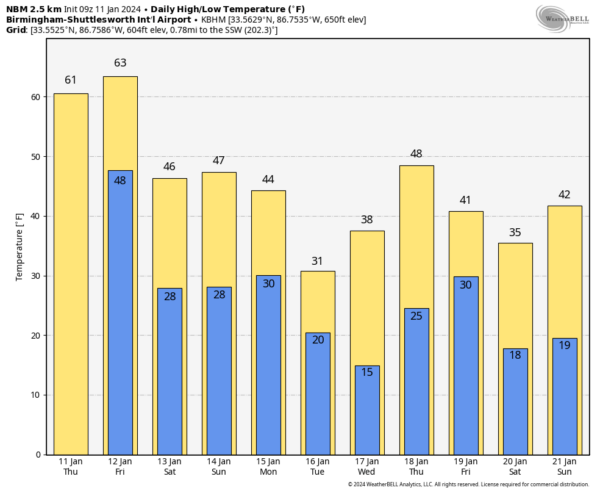
THE WEEKEND: The weather will be dry and colder over the weekend. Morning lows will be in the 23-32 degree range, with highs in the 40s over North Alabama, with 50s for the southern counties Saturday and Sunday.
ARCTIC BLAST NEXT WEEK: The coldest air so far this season rolls into the Deep South early next week. Global models continue to hint at the potential for some “wintry” precipitation over the northern half of Alabama Monday night into Tuesday morning. It remains too early to be specific, and we still can’t tell you if we will have travel or other impacts; once we get the system out of here tomorrow we can focus on Monday/Tuesday and have a higher confidence forecast.
We can tell you with confidence it will be very cold next week. Most of the state will stay below freezing all day Tuesday, and by Wednesday morning lows will drop into the 10-15 degree range over the northern half of the state, with teens all the way down to near I-10. This will be similar to the cold wave we experienced in December 2022. See the video briefing for maps, graphics, and more details.
ON THIS DATE IN 1918: A powerful area of low pressure brought snow and bitterly cold temperatures to Chattanooga, Little Rock, and Shreveport. Birmingham, Alabama, picked up an inch of snow. In far southeastern Alabama, an estimated F3 tornado virtually damaged every building in the town of Webb. The tornado leveled one rural school, killing one teacher and seven students.
ON THIS DATE IN 2021: Accumulating snow affected Pickens, Lamar, Fayette, Walker, Marion, and Winston counties in West Alabama. Reported snow totals were generally in the 1 to 2 inch range, with isolated amounts of up to 3 inches.
Look for the next video briefing here by 3:00 this afternoon… enjoy the day!
Category: Alabama's Weather, ALL POSTS, Weather Xtreme Videos


