Midday Nowcast: Dry Today, Strong and Severe Storms Tomorrow
Plenty of sunshine today with warmer temperatures this afternoon…we are seeing highs in the upper 50s and lower 60s for North/Central Alabama.
Tonight will not be as cold as our winds will be increasing out of the south which will bring a few scattered showers overnight.
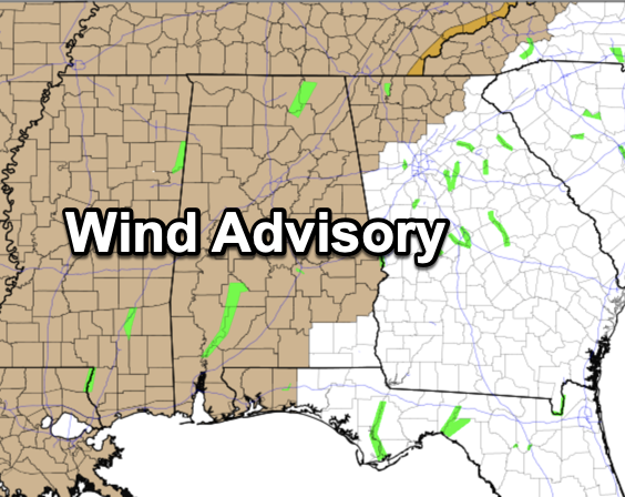
Gradient winds (non-thunderstorm) will gust to 35/45 mph later tonight and tomorrow, and a wind advisory is in effect. Not as intense as Monday night, but still trees could come down along with some power outages.
SEVERE STORMS RETURN: The SPC maintains an “enhanced risk” (level 3/5) of severe thunderstorms for parts of East, Central, and Southeast Alabama tomorrow. A “slight risk” (level 2/5) extends as far north as Winfield, Oneonta, and Gadsden… and a “marginal risk” (level 1/5) is up for the northern third of the state.
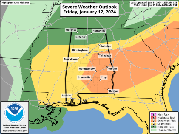
Not much change in the overall forecast as the main question is the northward extent of unstable air; for now we believe the highest risk of severe storms will be along and south of I-20, over the southern 2/3 of Alabama.
TIMING: This will be a daytime event with storm developing during the morning hours, and reaching the western counties of the state around 9AM. The threat will spread eastward through the state before exiting the state by 4 or 5 PM.
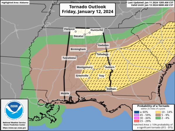
THREATS: Storms tomorrow will be capable of producing strong, damaging straight line winds, large hail, and some tornadoes. A few strong tornadoes (EF-2 or higher) are possible in the “enhanced risk” area over East and Southeast Alabama. We note we, there is a 10% hatched area covering East and Southeast Alabama. This hatched area means there is a 10% or greater probability of EF2 – EF5 tornadoes within 25 miles of a point within this area.
Rain amounts will be under one inch, and flooding is not expected.
CALL TO ACTION: Be ready to act immediately…Have multiple, reliable ways to receive severe weather alerts, NEVER, ever, ever rely on a siren. Every Alabama home and business needs a NOAA Weather Radio (the most popular model is the Midland WR-120, which is sold in most local big box retailers). The other way is your phone… be sure emergency alerts are enabled (look under settings, and notifications), and install the free ABC 33/40 Weather app.
Know the safe place in your house, and in that safe place have helmets for everyone. Bicycle helmets and batting helmets work well. We also recommend portable air horns and hard soled shoes for everyone. If you live in an apartment complex, you can’t be above the first level. Shelter with a friend on the ground level, or ask management if they can open the clubhouse during a tornado warning.
If you live in a mobile home, you cannot stay there during a tornado warning, they offer little to know protection from severe storms. Know the location of the nearest shelter, or business that is open 24/7. Know how to get there quickly.
BE A HERO: You can help us. Tell your friends, neighbors, and relatives about the threat, and what they need to do to get ready. And, if they fall in a tornado warning polygon, call them or text them to let them know about the threat. You are our most valuable resource in spreading the word!
Many of you have anxiety about severe weather, especially those that have gone through tornadoes or other kinds of violent weather. Have comfort knowing that even on the biggest severe weather days, odds of any one home being hit by a tornado are very low. But, you have to pay attention and be prepared.
We have been through events like this before, we will go through them again, and we will make it through this one together. Just be prepared and ready to act. Hopefully, we can make it through today with no major problems. No two events are the same, so don’t compare this event to ones in the past.This event is completely different, but it carries its own significant threat and everyone will need to be prepared. It only takes one storm to make this a very bad day for the state.
WEEKEND WEATHER: Saturday will be windy and sharply colder; temperatures will likely hold in the 30s over North Alabama, with 40s to the south. Temperatures should be well below freezing by Sunday morning, but will rebound into the 50s during the afternoon. Both days this weekend will be dry.
ARCTIC FLOODGATES: They open next week and the coldest air so far this season rolls into the Deep South early next week. Global models continue to hint at the potential for some “wintry” precipitation over the northern half of Alabama Monday night into Tuesday morning. It remains too early to be specific, and we still can’t tell you if we will have travel or other impacts; once we get the system out of here tomorrow we can focus on Monday/Tuesday and have a higher confidence forecast.
We can tell you with confidence it will be very cold next week. Most of the state will stay below freezing all day Tuesday, and by Wednesday morning lows will drop into the 10-15 degree range over the northern half of the state, with teens all the way down to near I-10. This will be similar to the cold wave we experienced in December 2022.
BEACH FORECAST CENTER: Get the latest weather and rip current forecasts for the beaches from Fort Morgan to Panama City on our Beach Forecast Center page. There, you can select the forecast of the region that you are interested in visiting.
WORLD TEMPERATURE EXTREMES: Over the last 24 hours, the highest observation outside the U.S. was 116.2F at Sikasso, Mali. The lowest observation was -68.4F at Yurty, Russia.
CONTIGUOUS TEMPERATURE EXTREMES: Over the last 24 hours, the highest observation was 78F at Miami, Florida. The lowest observation was -16F at Hilger, MT.
Category: Alabama's Weather, ALL POSTS
About the Author (Author Profile)
Macon, Georgia Television Chief Meteorologist, Birmingham native, and long time Contributor on AlabamaWX. Stormchaser. I did not choose Weather, it chose Me. College Football Fanatic. @Ryan_StinnetSubscribe
If you enjoyed this article, subscribe to receive more just like it.


