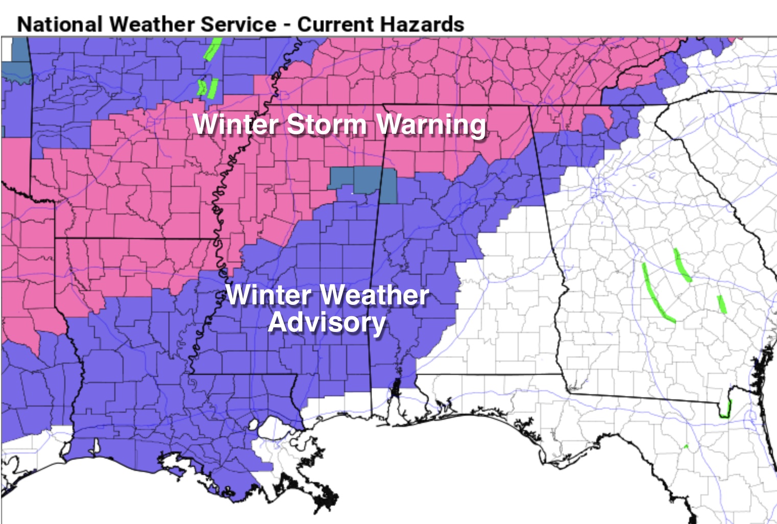
Winter Storm Warning/Winter Weather Advisory For Much Of Alabama
COLD/SNOW/ICE: A messy winter weather setup continues for much of Alabama today. A winter storm warning remains in effect for Marion, Winston, Franklin, Colbert, Lauderdale, Lawrence, Limestone, Cullman, Morgan, Madison, Marshall, Jackson, and DeKalb counties in North Alabama. A winter weather advisory is now in effect west of a line from Mobile to Selma to Clanton to Sylacauga to Ranburne.
Here are the key messages this morning….
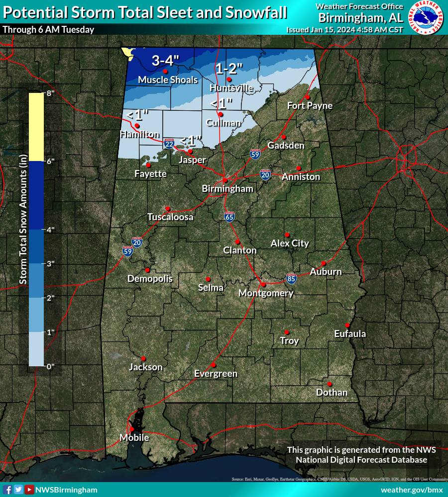
*Most of the accumulating snow will come along and north of the Tennessee River where 2-4 inch totals are possible. Amounts over 5 inches are possible around the Shoals before it ends tonight. Light snow accumulation is possible as far south as Hamilton, Cullman, and Fort Payne.
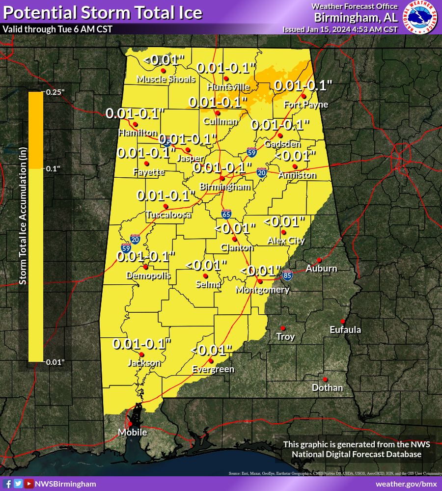
*South of the Tennessee River, freezing rain and drizzle will be the primary issue. This is precipitation that falls in liquid form when surface temperatures are below 32 degrees. It can bring a glaze of ice to exposed surfaces, including bridges and some roads.
*Temperatures will remain below freezing all day today over the northern third of the state, in the winter storm warning area. Roads will be icy and hazardous there.
*The Arctic front drops southward, and temperatures go below freezing over the winter weather advisory area late this afternoon and tonight. As light freezing rain and drizzle falls, bridges will become icy. Some black top road surfaces will become icy.
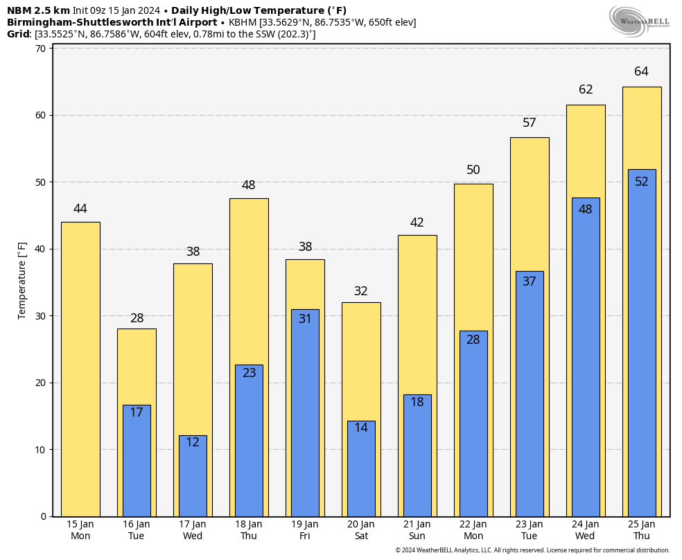
*Temperatures will remain below freezing over much of North/Central Alabama through the late morning hours Wednesday, so travel conditions won’t improve much until then.
*This cold wave will be similar to that of December 2022. Lows will drop into the teens both tomorrow and Wednesday morning, with single digit lows likely over the northern third of the state early Wednesday. Wind chill values will be very low, below zero at times tomorrow, tomorrow night, and early Wednesday. Temperatures reach the upper teens along the Gulf Coast Wednesday morning.
-Learn how to shut off water valves for potential pipe bursts.
-Check on the elderly and others that might not have an adequate heat source.
-Bring pets inside.
LATER THIS WEEK: Temperatures rise into the upper 40s and low 50s Thursday, but another batch of Arctic air invades the state Thursday night and Friday. There is a chance a “wintry mix” is possible over the northern third of the state Thursday night; we will focus on that potential tomorrow… for most of the state it will be just a cold light rain at times.
The sky will clear on Friday with highs only in the 30s over the northern half of the state, with low 40s to the south. A brisk north wind will make it feel colder.
THE ALABAMA WEEKEND: The weekend will be dry but very cold. Lows will be in the teens for most places Saturday and Sunday morning. North Alabama will stay below freezing all day Saturday. Temperatures rise into the 40s Sunday afternoon as we begin to dig out of the deep freeze.
NEXT WEEK: The pattern flips, and we will be in the 60s by mid-week. Global models suggest rain will return to the state by Thursday… See the video briefing for maps, graphics, and more details.
ON THIS DATE IN 1967: The Green Bay Packers beat the Kansas City Chiefs, 35-10, in Super Bowl I at the Memorial Coliseum in Los Angeles. From the weather station at the USC campus in downtown LA, the high temperature was 79 degrees, and the low was 51. There was a light west wind.
Look for the next video briefing here by 3:00 this afternoon… enjoy the day!
Category: Alabama's Weather, ALL POSTS, Weather Xtreme Videos
About the Author (Author Profile)
James Spann is one of the most recognized and trusted television meteorologists in the industry. He holds the AMS CCM designation and television seals from the AMS and NWA. He is a past winner of the Broadcast Meteorologist of the Year from both professional organizations.Subscribe
If you enjoyed this article, subscribe to receive more just like it.


