Light Rain Moves Into Alabama Later Today; Another Arctic Blast Tomorrow
TODAY: Temperatures are below freezing across Alabama, mostly in the 15-25 degree range… not as cold as yesterday morning. The sky becomes cloudy today, and we will mention the chance of some light rain at times. Initially over West Alabama late this morning, then spreading eastward through the afternoon. Rain amounts will be very light, mostly under one-tenth of an inch.
Temperatures could be in the low 30s across Northwest Alabama and the Tennessee Valley as the rain begins, meaning it could be freezing rain for a brief window. With many roads still snow/ice covered, this certainly isn’t good, but again precipitation will be very light, and most places will be above freezing by mid-afternoon. NWS Huntsville has opted not to issued any advisories.
Understand the brief trip into the mid 30s across the northern quarter of the state certainly won’t melt all of the existing snow and ice off the roads, and travel impact will remain possible through Sunday morning due to a new shot of very cold air moving in. There will be no travel impact in terms of snow or ice from I-20 south.
The light rain will end from west to east across Alabama tonight.
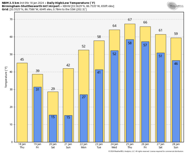
TOMORROW AND THE WEEKEND: Another surge of Arctic air moves into Alabama tomorrow. Temperatures will hold in the 30s all day with a clearing sky. We drop into the 10-15 degree range Sunday morning over the northern half of the state, with lows between 15-25 for the southern counties. Sunday morning should be just as cold. The sky will be sunny Saturday and Sunday, but on Saturday most of North Alabama stays below freezing all day. Sunday’s high will be in the 40s.
NEXT WEEK: We have a major pattern flip across North America, setting the stage for a big warm-up. Highs will be in the 60s over the latter half of the week, and South Alabama could see low 70s. Monday will be dry, but we will forecast periods of rain on a daily basis Tuesday through Friday as a moist airmass moves in, and we have a persistent southwest flow aloft. Rain amounts will be in the 1-2 inch range, and the chance of rain will likely linger into the following weekend (January 27-28). See the video briefing for maps, graphics, and more details.
ON THIS DATE IN 1971: A warm Santa Ana condition brought a 95 degree reading to Los Angeles, the highest January temperature on record. It was 95 degrees in Palm Springs, the highest temperature on record for January as well.
ON THIS DATE IN 1978: In Connecticut, the Hartford Arena collapsed after experiencing the largest snowstorm of its 5-year life. Multiple issues caused the collapse.
Look for the next video briefing here by 3:00 this afternoon… enjoy the day!
Category: Alabama's Weather, ALL POSTS, Weather Xtreme Videos


