Cold Front Arrives Tonight With A Few Showers; Much Colder Tomorrow
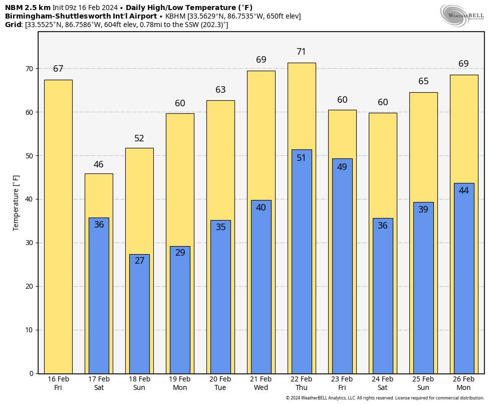
STILL MILD TODAY: We project a high in the 65-70 degree range for much of Alabama today with a veil of high clouds overhead. We note the average high for Birmingham on February 16 is 59. A few sprinkles are possible near the Gulf Coast today, but for most places the weather will stay dry.
A cold front arrives tonight with a band of showers; moisture will be limited and rain amounts will be light… mostly one tenth of an inch or less. These showers will likely end very early tomorrow, but clouds will linger through midday. The big story is a change to much colder air. Temperatures will hold in the 40s over the northern 2/3 of the state with a brisk north wind to make it feel even colder. Clearing will likely begin during the afternoon over the northern counties.
We begin the day Sunday with temperatures between 24 and 34 degrees… the day will be sunny with a high in the 50s.
NEXT WEEK: The warming trend continues Monday… with a good supply of sunshine we expect a high in the 60s. A disturbance could bring a few sprinkles to the state Tuesday, but meaningful rain amounts are not expected. Then, another cold front will bring a chance of showers Thursday afternoon and Thursday night. Amounts will be light, and dry air will return Friday. Afternoon temperatures will be close to 70 Wednesday and Thursday, then falling to near 60 Friday.
We still see no any high impact weather events through the rest of February… no severe cold, snow, ice, severe storms, heavy rain, or flooding. See the video briefing for maps, graphics, and more details.
ON THIS DATE IN 1995: An upper end F3 tornado moved through parts of Cullman and Marshall counties in North Alabama during the early morning hours, hitting the communities of Joppa and Arab hard. Six people were killed, another 130 were injured. Joppa Elementary School was destroyed.
The tornado warning was issued at the last minute, and many never received it because the Huntsville weather radio transmitter was knocked off the air by a lightning strike. Ironically, the Huntsville National Weather Service was scheduled to close as part of the modernization of the weather service. The National Weather Service in Birmingham was scheduled to take over responsibility for the counties in North Alabama. The Arab tornado fomented an uproar against closing the Huntsville office.
Critics claimed that the missed warning gave credence to their charge that 54 counties were too many for the Birmingham office. On December 2, 1997, the Huntsville NWS Office closed. But under tremendous pressure from many people, led by Representative Bud Cramer, a new National Weather Service Office would open in Huntsville. It has responsibility for eleven North Alabama Counties and three counties in southern Tennessee. Cullman County emergency managers pushed to be a part of the Huntsville County Warning Area, and their wish was granted.
However, the “Cullman County situation” within the weather enterprise still creates confusion today; the county is in the Huntsville National Weather Service CWA (County Warning Area), but is in the Birmingham television market.
Look for the next video briefing here by 3:00 this afternoon… enjoy the day!
Category: Alabama's Weather, ALL POSTS, Weather Xtreme Videos
About the Author (Author Profile)
James Spann is one of the most recognized and trusted television meteorologists in the industry. He holds the AMS CCM designation and television seals from the AMS and NWA. He is a past winner of the Broadcast Meteorologist of the Year from both professional organizations.Subscribe
If you enjoyed this article, subscribe to receive more just like it.


