Midday Nowcast: Clouds for Days
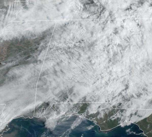
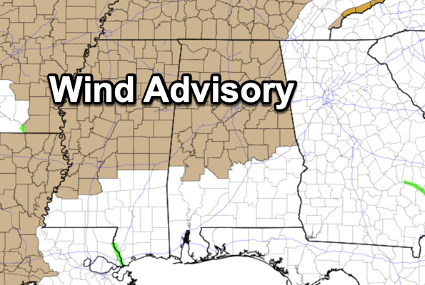
I hoped you enjoyed the sun the past few days, because we may not see it fully for quite some time. Today is featuring a cloudy sky, but despite the clouds it is a very warm day as temperatures are surging into the upper 70s and lower 80s. A wind advisory is in effect for the northern two-thirds of the state and will remain in effect through tomorrow. Winds will be increasing and will be sustained above 20 mph, while gusts to 40 mph are possible.
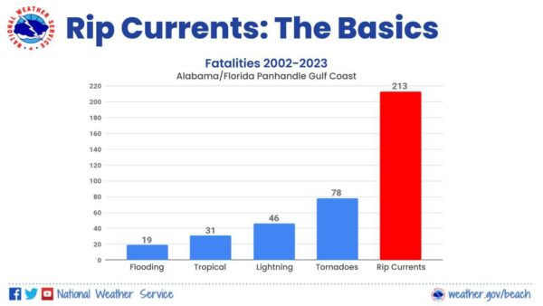
RIP CURRENT AWARENESS WEEK: Our great friends at the NWS Offices in Mobile and Tallahassee want to remind everyone that the deadliest weather-related killer along the Gulf Coast doesn’t come from the sky, but from the sea. We all love the beach – the sun, the sand, and the surf. BUT! Just because you are having fun at the beach does NOT mean you can forget about safety. Rip currents are the #1 weather-related killer at the beaches along the northern Gulf Coast. There have been a staggering 213 rip current fatalities since 2002 in the beaches covered by the National Weather Service Offices in Tallahassee, FL and Mobile, AL. That is more than the fatalities of flooding, tornadoes, lightning, and tropical storms/hurricanes COMBINED!! [Note: Rip current fatalities are only across our coastal counties with beaches (2 in Alabama and 7 in Florida), whereas the other fatalities are spread across the entire forecast area that spans 68 counties in Alabama, Florida, Georgia, and Mississippi.]
USA BRIEF: A strengthening winter storm with trailing cold front will continue to progress across the central U.S. today then the eastern U.S. on Wednesday. Areas of heavy snow, severe thunderstorms, record high temperatures, high winds, and critical fire weather are expected due to the storm. Another storm system is likely to spread heavy rain and snow with strong winds across the West later this week.
WHACKY WEDNESDAY: A cold front will push into Alabama, bringing a band of showers and possibly a thunderstorm or two; there is no risk of severe storms. Temperatures will likely rise into the 70s earl in the day, but as the front pushes south, temperatures will take a tumble falling through the 60s and into the 50s during the afternoon. In fact, by early afternoon, there will be a very sharp thermal gradient across the state as temperatures will be in the 40s over the northern third of the state, while South Alabama will be in the 70s and 80s.
COOLER END TO WEEK: Thursday will be dry and cool, with highs in the 50s over North/Central Alabama with more clouds than sun. On Friday, a wave of low pressure will bring rain back to the state. It will be a cool rain with temperatures in the 50s; no risk of severe weather and likely no thunder.
THE ALABAMA WEEKEND: The sky will be remain generally cloudy, with scattered showers possible both days. Nothing too heavy or widespread, and it won’t be a weekend washout, but we will have scattered areas of rain possible at anytime. It will be warmer with highs mostly in the upper 60s Saturday, followed by low 70s Sunday.
NEXT WEEK: Some scattered showers remain possible Monday…showers and storms are more likely late Monday night into Tuesday ahead of another cold front. A few strong storms will be possible, but for now the risk of severe storms looks low with the best dynamic forcing to the north. Drier air along with sunshine returns by Thursday and Friday with highs in the 60s.
BEACH FORECAST CENTER: Get the latest weather and rip current forecasts for the beaches from Fort Morgan to Panama City on our Beach Forecast Center page. There, you can select the forecast of the region that you are interested in visiting.
WORLD TEMPERATURE EXTREMES: Over the last 24 hours, the highest observation outside the U.S. was 115.3F at Ceduna Airport, Australia. The lowest observation was -71.7F at Vostok, Antarctica.
CONTIGUOUS TEMPERATURE EXTREMES: Over the last 24 hours, the highest observation was 100F at Killeen, TX. The lowest observation was -13F at Mackay, ID.
Category: Alabama's Weather, ALL POSTS
About the Author (Author Profile)
Macon, Georgia Television Chief Meteorologist, Birmingham native, and long time Contributor on AlabamaWX. Stormchaser. I did not choose Weather, it chose Me. College Football Fanatic. @Ryan_StinnetSubscribe
If you enjoyed this article, subscribe to receive more just like it.


