Midday Nowcast: Temperatures are Taking a Tumble
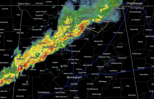
A cold front is moving through Alabama bringing a band of showers and storms. At this writing of this forecast, the line of storms was stretching from Scottsboro to Cullman to Fayette and it continues to move south and east through the state quickly. It it a very wind day and the wind advisory remains in effect as winds are gusting to 35-40 mph. For most of North/Central Alabama, the highs have already occurred today with lower 70s. As the front pushes pass your location, temperatures will take a tumble and many of us will be in the 40s later this afternoon with wind chills in the 30s.
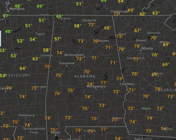
Northwest Alabama already has temperatures in the 40s and that colder air is racing south. Tonight will be a cold one as lows settle down into the lower and mid 30s.
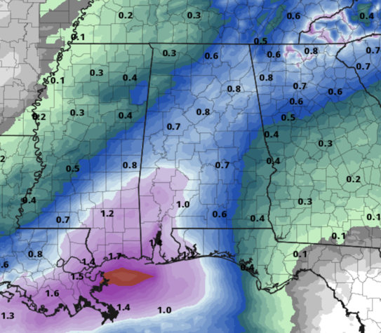
TOMORROW/FRIDAY: Tomorrow will be dry and cool, with highs in the 50s over North/Central Alabama with more clouds than sun. On Friday, a wave of low pressure will bring a widespread rain back to the state. It will be a chilly rain as temperatures will be in the low 50s; there is no risk of severe weather and likely little thunder. Rainfall totals on Friday will be near one inch.
THE ALABAMA WEEKEND: The sky will be remain generally cloudy, with scattered showers possible both days. Nothing too heavy or widespread, and it won’t be a weekend washout, but we will have scattered areas of rain possible at anytime. It will warmer with highs mostly in the upper 60s Saturday, followed by low 70s Sunday.
NEXT WEEK: Showers remain possible Monday, and showers and storms are more likely late Monday night into Tuesday ahead of another cold front. The front will stall across the state and the weather will remain unsettled all week. It will remain cloudy with rain possible at anytime Tuesday through Friday. It will be mild all week with highs in the 60s and 70s. As stated yesterday, expect continued cloud cover for the next 7-10 days with only limited amounts of sunshine. Welcome to what it is like to live in the Pacific Northwest most of the year.
BEACH FORECAST CENTER: Get the latest weather and rip current forecasts for the beaches from Fort Morgan to Panama City on our Beach Forecast Center page. There, you can select the forecast of the region that you are interested in visiting.
WORLD TEMPERATURE EXTREMES: Over the last 24 hours, the highest observation outside the U.S. was 113.9F at Paraburdoo Aero, Australia. The lowest observation was -74.9F at Dome C, Antarctica.
CONTIGUOUS TEMPERATURE EXTREMES: Over the last 24 hours, the highest observation was 99F at Falcon Village, TX. The lowest observation was -16F at Kelliher, MN.
Category: Alabama's Weather, ALL POSTS
About the Author (Author Profile)
Macon, Georgia Television Chief Meteorologist, Birmingham native, and long time Contributor on AlabamaWX. Stormchaser. I did not choose Weather, it chose Me. College Football Fanatic. @Ryan_StinnetSubscribe
If you enjoyed this article, subscribe to receive more just like it.


