Lingering Light Rain Ends Soon; Only Isolated Showers This Afternoon
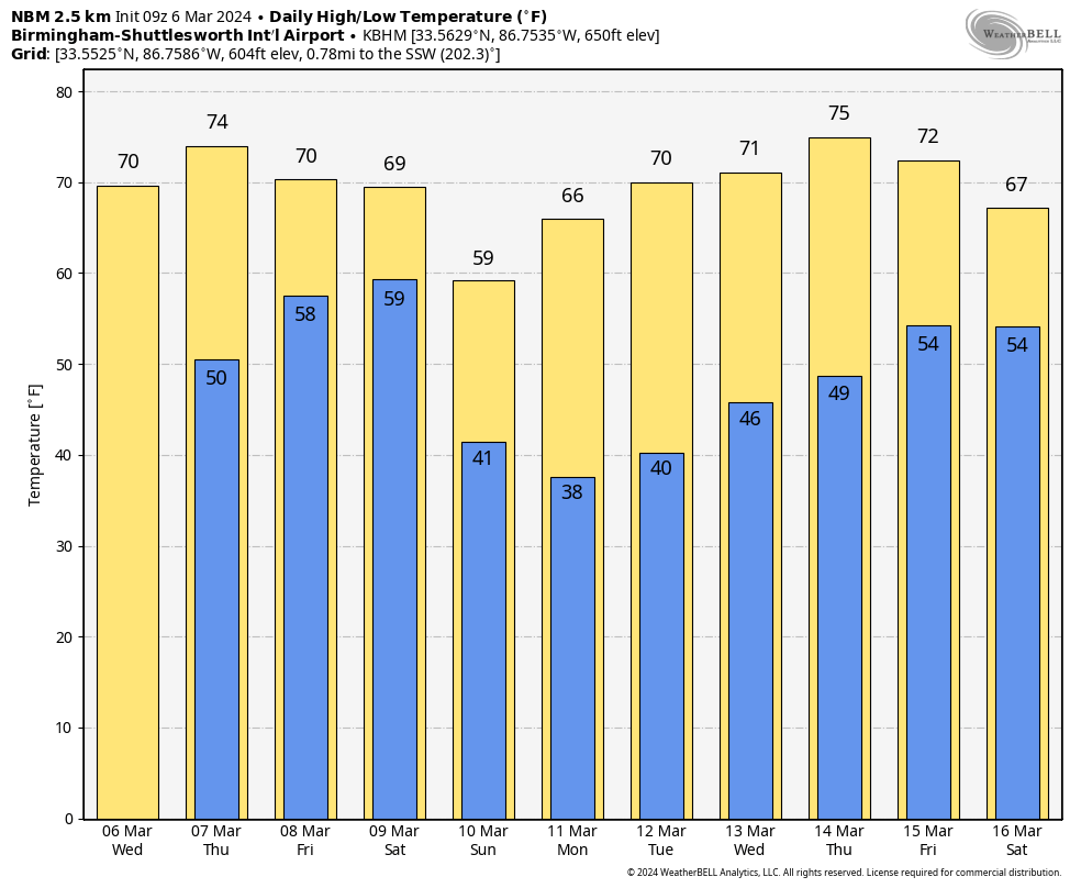
RADAR CHECK: We have some lingering light rain over the northern half of Alabama early this morning; it should be out of the state soon. Clouds linger through the morning, but a few intervals of sun are possible this afternoon. A few isolated showers could show up this afternoon, but odds of any one spot getting wet are 15/20 percent. The high today will be close to 70 degrees for most places.
Tomorrow will be a day, mild day with a partly sunny sky along with a high in the 70s.
FRIDAY AND THE WEEKEND: Clouds thicken Friday, and a weather system will bring more rain to Alabama Friday afternoon, Friday night, and into Saturday morning. SPC has defined a “slight risk” (level 2/5) of severe thunderstorms for areas south of a line from York to Greenville to Dothan. A “marginal risk” (level 1/5) is in place as far north as Florence, Snead, and Ranburne.
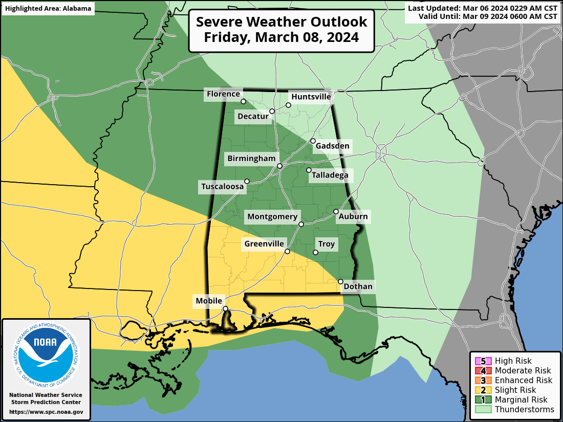
Storms over South Alabama Friday night could produce hail and strong winds, also an isolated tornado can’t be totally ruled out. For North/Central Alabama, the severe weather threat looks low at this time due to the lack of surface based instability.
The bulk of the rain should come from about 3:00 p.m. Friday through 9:00 a.m. Saturday. Rain amounts across Alabama will be generally in the 1-3 inch range; a few isolated flooding issues are possible, but for now it doesn’t look like flooding problems will be especially widespread. Clouds will linger through Saturday, but a surge of cooler, drier air will arrive Saturday night. The high Friday and Saturday will be in the 68-72 degree range.
Sunday will be a sunny, cooler day with highs between 57 and 64 degrees.
NEXT WEEK: Global models suggest most of next week will be dry across Alabama with highs in the 60s on Monday, followed by low to mid 70s Tuesday through Friday. The next significant rain event most likely will come at some point during the following weekend (March 15/16). While some of the colder pockets across North Alabama could be close to freezing Monday morning (March 11), still no sign of any major, widespread late season freeze for the Deep South for the next ten days. See the video briefing for maps, graphics, and more details.
ON THIS DATE IN 1962: The strongest nor’easter of this century struck the Mid-Atlantic Region on March 5-9, 1962. It is known as the “Ash Wednesday Storm” and caused over $200 million (1962 dollars) in property damage and significant coastal erosion from North Carolina to Long Island, New York. It was estimated to have destroyed or significantly damaged 45,000 homes in New Jersey alone. The Red Cross recorded that the storm killed 40 people.
ON THIS DATE IN 1967: The F4 tornado cut a thirty mile path across Walker and Jefferson Counties. It would strike Sumiton, Rocky Hollow, Dilworth, Empire and North Warrior. The tornado caused heavy damage at Dilworth and killed a 27 year old woman. The tornado lifted after passing near Warrior. A total of fifty homes were damaged or destroyed across Walker and northern Jefferson Counties. A total of two people died.
ON THIS DATE IN 1996: Tornadoes killed 7 people and injured 45 others in Alabama. Just after 4:00a CT, a tornado touched down 9 miles west of Selma, and moved east-northeast on a path at least 10 miles long. A trailer park was hit just north of Selma, killing 4 people. Another tornado just east of Montgomery killed 2 people. There were a total of 6 tornadoes reported on this day in the state.
Look for the next video briefing here by 3:00 this afternoon… enjoy the day!
Category: Alabama's Weather, ALL POSTS, Weather Xtreme Videos
About the Author (Author Profile)
James Spann is one of the most recognized and trusted television meteorologists in the industry. He holds the AMS CCM designation and television seals from the AMS and NWA. He is a past winner of the Broadcast Meteorologist of the Year from both professional organizations.Subscribe
If you enjoyed this article, subscribe to receive more just like it.


