Midday Nowcast: More Clouds than Sun; Storms Return Friday Night
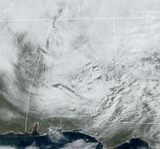
A few isolated showers will remain possible this afternoon across Alabama, but nothing widespread or heavy. We are seeing more clouds than sunshine; overall it is a pretty decent Wednesday across Alabama. Tonight will feature areas of fog with lows in the 50s and 60s. Tomorrow, will be the best day of weather this week, we should see more sun than clouds, and temperatures will be in the mid to upper 70s.
USA BRIEF: Isolated strong to severe thunderstorms could occur today across parts of the southern Plains, with large hail and gusty winds possible. A coastal storm will bring heavy rainfall and the threat of isolated flash flooding across the Mid-Atlantic and Northeast today. Gusty winds and dry conditions will continue the elevated threat for wildfires in the central and southern High Plains today.
FRIDAY/SATURDAY: Clouds will once again increase across Alabama ahead of our next storm system. Rain and storms will return to Alabama late Friday, Friday night, and into early Saturday. The SPC has defined a “slight risk” (level 2/5) of severe thunderstorms for areas south of a line from York to Greenville to Dothan. A “marginal risk” (level 1/5) is in place as far north as Florence, Snead, and Ranburne.
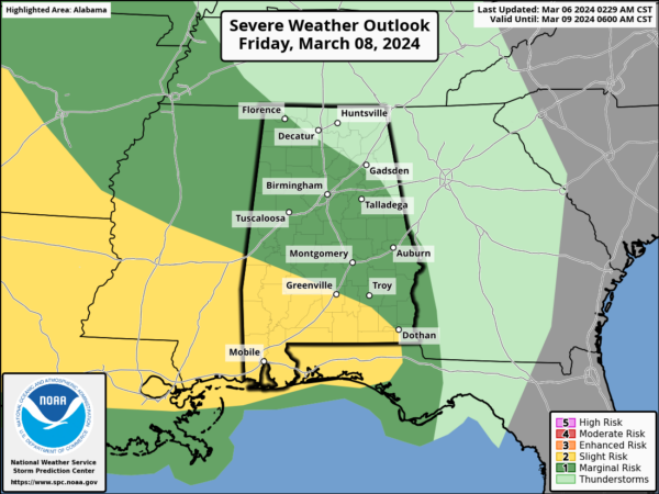
Storms over South Alabama Friday night could produce hail and strong winds, also an isolated tornado can’t be ruled out. For North/Central Alabama, the severe weather threat looks low at this time due to the lack of surface based instability, but we could certainly see a few stronger storms producing gusty winds. The core threat for stronger storms will come from 9PM Friday – 9AM Saturday. Heavy rainfall will be the main issue as rain amounts will be generally in the 1-3 inch range, with isolated higher amounts possible.
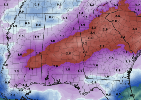
With already have saturated grounds and that could lead to areas of isolated flooding. The rain and storms will push east early Saturday, but clouds are likely to linger most of the day. Saturday night, a surge of drier air will drop into Alabama finally clearing us out.
SUNDAY: Sunshine is back for the second half of the weekend. Along with bright sunshine, Sunday will be cooler with highs in the upper 50s and lower 60s. Sunday night will be chilly as lows fall back into the upper 30s.
NEXT WEEK: A drier weather pattern settles into Alabama next week with plenty of sunshine and very comfortable temperatures. Highs Monday will be in the 60s, but low to mid 70s are expected the rest of the week. The next significant rain event most likely will come at some the following weekend (March 16th/17th). Way too early to know if severe storms will be an issue, but tis the season and we will be watching trends over the next 7-10 days.
BEACH FORECAST CENTER: Get the latest weather and rip current forecasts for the beaches from Fort Morgan to Panama City on our Beach Forecast Center page. There, you can select the forecast of the region that you are interested in visiting.
WORLD TEMPERATURE EXTREMES: Over the last 24 hours, the highest observation outside the U.S. was 111.2F at Ndjamena, Chad. The lowest observation was -73.5F at Amundsen-Scott South Pole Station, Antarctica.
CONTIGUOUS TEMPERATURE EXTREMES: Over the last 24 hours, the highest observation was 95F at Kingsville, TX. The lowest observation was -4F at White Sulphur Springs, MT.
Category: Alabama's Weather, ALL POSTS
About the Author (Author Profile)
Macon, Georgia Television Chief Meteorologist, Birmingham native, and long time Contributor on AlabamaWX. Stormchaser. I did not choose Weather, it chose Me. College Football Fanatic. @Ryan_StinnetSubscribe
If you enjoyed this article, subscribe to receive more just like it.


