Warm Again Today; Strong/Severe Storms Late Tomorrow/Tomorrow Night
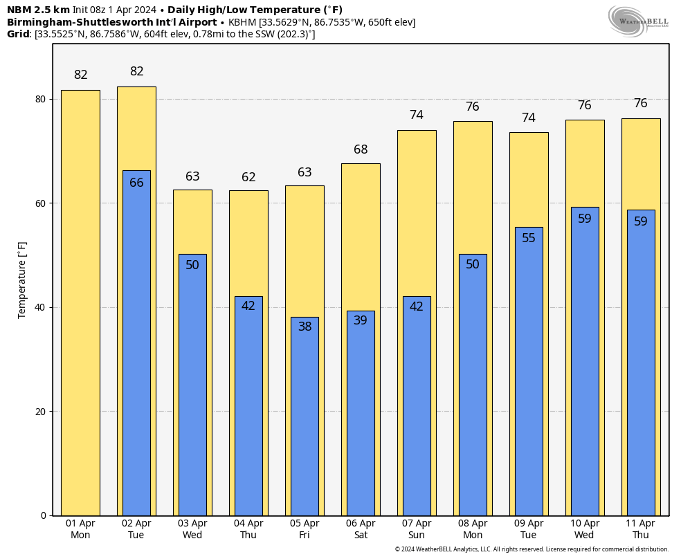
WARM START TO APRIL: Today will be another warm, dry day for Alabama with a high in the low 80s in most places with a mix of sun and clouds. The weather becomes active late tomorrow and tomorrow night as an organized band of showers and thunderstorms moves into the Deep South.
SPC has defined an “enhanced risk” (level 3/5) of severe thunderstorms for the Tennessee Valley of North Alabama; a “slight risk” (level 2/5) extends as far south as Demopolis, Clanton, and Ranburne. For South Alabama, a “marginal risk” (level 1/5) is in place.
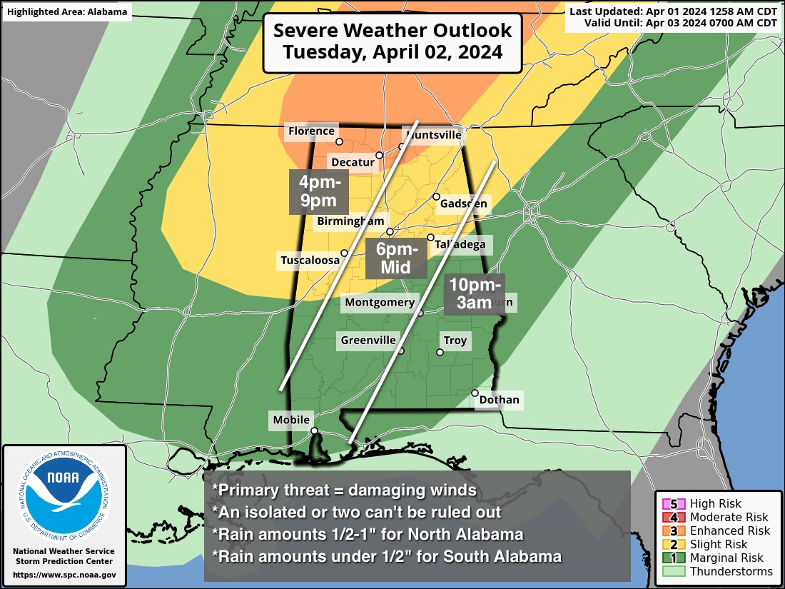
The primary window for strong to severe thunderstorms will come from around 4:00 p.m. tomorrow through 2:00 a.m. Wednesday. The main threat for Alabama will come from strong, potentially damaging straight line winds. The main parameters needed for tornadoes will be to the north, although an isolated tornado or two can’t be ruled out across North Alabama tomorrow night. Some hail is possible as well.
Rain amounts will be in the 1/2 to 1 inch for the northern half of Alabama, and under 1/2 inch for the southern counties of the state.
Wednesday will be breezy and much cooler with highs in the 57-64 degree range over North Alabama along with lingering clouds. South Alabama will see lots of sun Wednesday with a high in the 60s. Thursday and Friday will be sunny and cool statewide with a high in the 60s.
FROST/FREEZE THREAT: We have frost potential over the northern 2/3 of Alabama Friday, and possibly Saturday morning. Colder spots could see a freeze. Growers will need to monitor temperature forecasts.
THE WEEKEND: Dry weather continues over the weekend with lots of sun along with highs in the 70s. Next chance of showers will be at some point around the middle part of the following week. See the video briefing for maps, graphics, and more details.
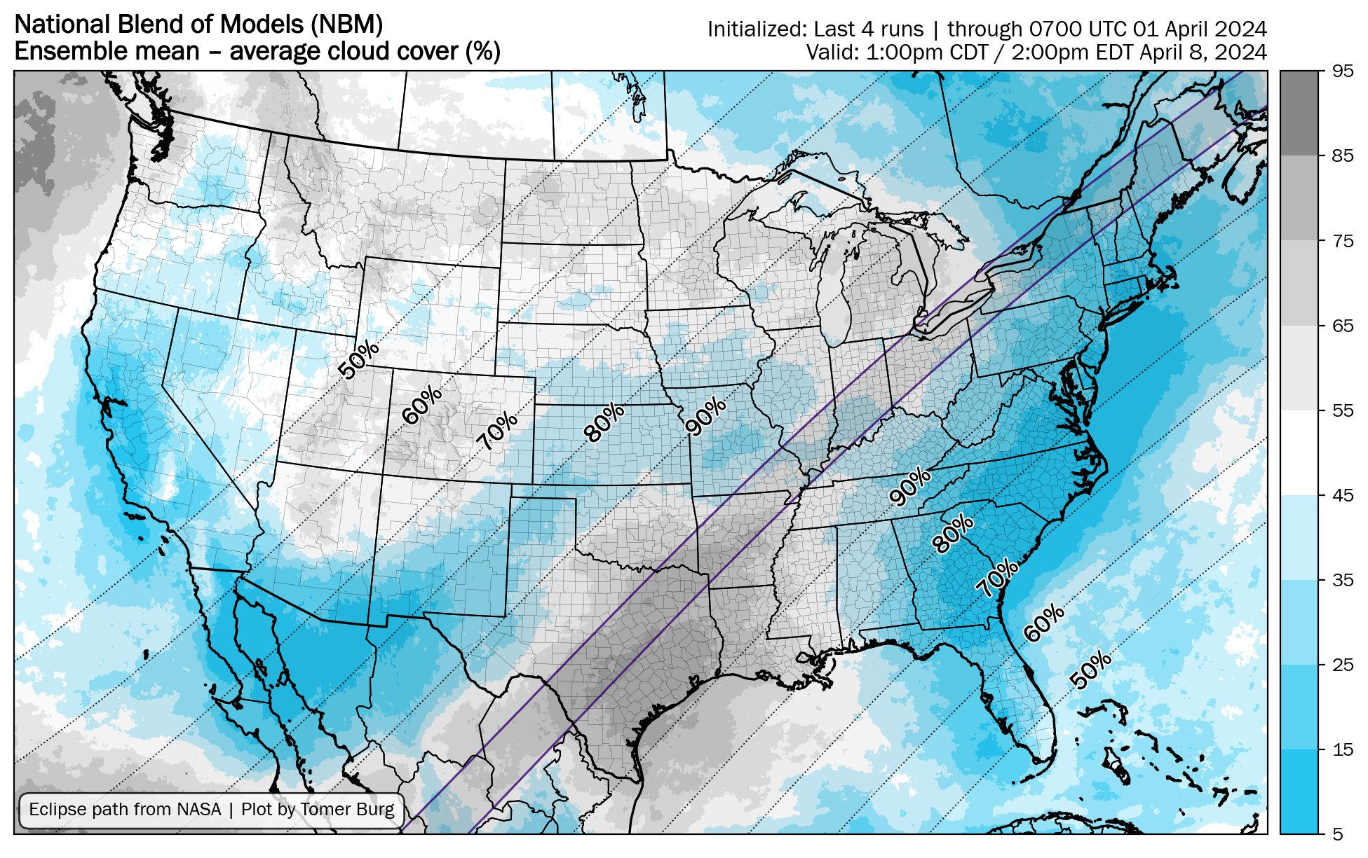
ECLIPSE WEATHER: Alabama will experience a partial solar eclipse one week from today (Monday April 8)… for now we are forecasting a partly sunny sky. For those in the path of totality to the west and north of here, clouds will likely be an issue for states like Texas, Arkansas, and Missouri.
ON THIS DATE IN 1960: The first weather satellite, TIROS 1 (Television and Infra-Red Observation Satellite) began sending pictures back to Earth. The TIROS series would have little benefit to operational weather forecasters because the image quality was low and inconsistent. The most critical understanding achieved from the new technology was the discovery of the high degree of organization of large-scale weather systems, a fact never apparent from ground and aircraft observations.
ON THIS DATE IN 2023: An EF-3 tornado moved through northern Madison County near Hazel Green; one person was killed. An EF-1 tornado moved through parts of Marion and Winston counties.
Look for the next video briefing here by 3:00 this afternoon… enjoy the day!
Category: Alabama's Weather, ALL POSTS, Weather Xtreme Videos
About the Author (Author Profile)
James Spann is one of the most recognized and trusted television meteorologists in the industry. He holds the AMS CCM designation and television seals from the AMS and NWA. He is a past winner of the Broadcast Meteorologist of the Year from both professional organizations.Subscribe
If you enjoyed this article, subscribe to receive more just like it.


