

Warm, Calm Weather Continues Through Friday
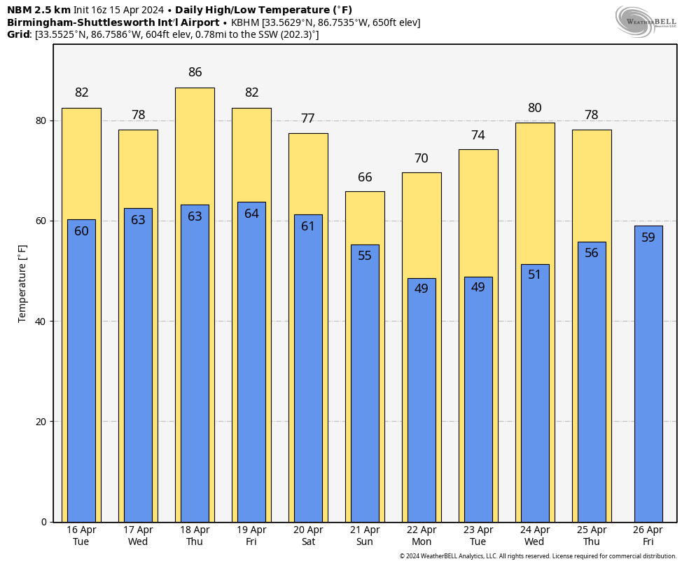
ANOTHER WARM DAY: We project a high in the low 80s for most communities across Alabama today. The sky will feature more clouds than sun, and while a sprinkle or two can’t be ruled out, most places will stay dry.
We will mention the chance of a few isolated showers over the northern half of Alabama tomorrow, but the chance of any one spot getting wet is less than 30 percent, and the southern counties will stay rain-free. The high tomorrow will be in the 77-82 degree range.
Thursday should be the warmest day of the week… with a mix of sun and clouds afternoon temperature reach the mid to upper 80s.
FRIDAY AND THE WEEKEND: A few isolated showers are possible Friday over North Alabama, but again most places will stay dry with a high in the low 80s. Then, expect a mostly cloudy sky over the weekend with occasional showers possible both days thanks to a weak front drifting southward. Highest coverage of showers Saturday will be over the northern 2/3 of the state, and statewide on Sunday. There could be a rumble of thunder, but no severe storms and rain amounts should be relatively light (mostly under 1/2 inch).
The weekend won’t be a wash-out, but just be ready for some rain at times if you have something planned outdoors. We will have a significant cooling trend; the high Saturday will be in the 70s, and much of the state won’t get out of the 60s Sunday.
NEXT WEEK: Most of the week will be dry with a warming trend; the high will be close to 80 by Wednesday. Still no sign of any high impact weather event (severe storms, flooding) for at least the next 7-10 days for Alabama. See the video briefing for maps, graphics, and more details.
RACE WEEKEND: The sky will be mostly cloudy at Talladega over the weekend with occasional showers both days. No way at this point to know the exact timing of the rain, but just understand delays will be possible for the races Saturday, and the Geico 500 Sunday. No wash-out, but be ready for some rain at times. The high Saturday will be in the mid 70s, followed by mid 60s Sunday as cooler air arrives. Some thunder can’t be ruled out, but there is no risk of severe storms, and rain amounts should be fairly light.
ON THIS DATE IN 1998: An historic tornado outbreak of at least 13 tornadoes struck Middle Tennessee on April 16, 1998. Many of these tornadoes were strong or violent and tracked long distances, killing 4 people and injuring nearly 100 people, while causing hundreds of millions of dollars in damage. One tornado during the outbreak struck downtown Nashville, blowing out numerous windows in skyscrapers and causing the collapse of some older buildings. Other notable tornadoes included three violent tornadoes in southern Middle Tennessee that reached F4 to F5 intensity, and an F3 tornado in Pickett County that damaged or destroyed hundreds of homes and businesses. Wilson County was struck by 4 different tornadoes during the event.
Look for the next video briefing here by 3:00 this afternoon… enjoy the day!
Category: Alabama's Weather, ALL POSTS, Weather Xtreme Videos
About the Author (Author Profile)
James Spann is one of the most recognized and trusted television meteorologists in the industry. He holds the AMS CCM designation and television seals from the AMS and NWA. He is a past winner of the Broadcast Meteorologist of the Year from both professional organizations.Subscribe
If you enjoyed this article, subscribe to receive more just like it.


