Periods Of Rain; A Few Strong Storms Tomorrow/Saturday
WARM, DRY AFTERNOON: The sky is partly to mostly sunny across Alabama this afternoon with temperatures generally in the 80s. Clouds will increase tonight ahead of an approaching storm system. Some rain is likely after midnight.
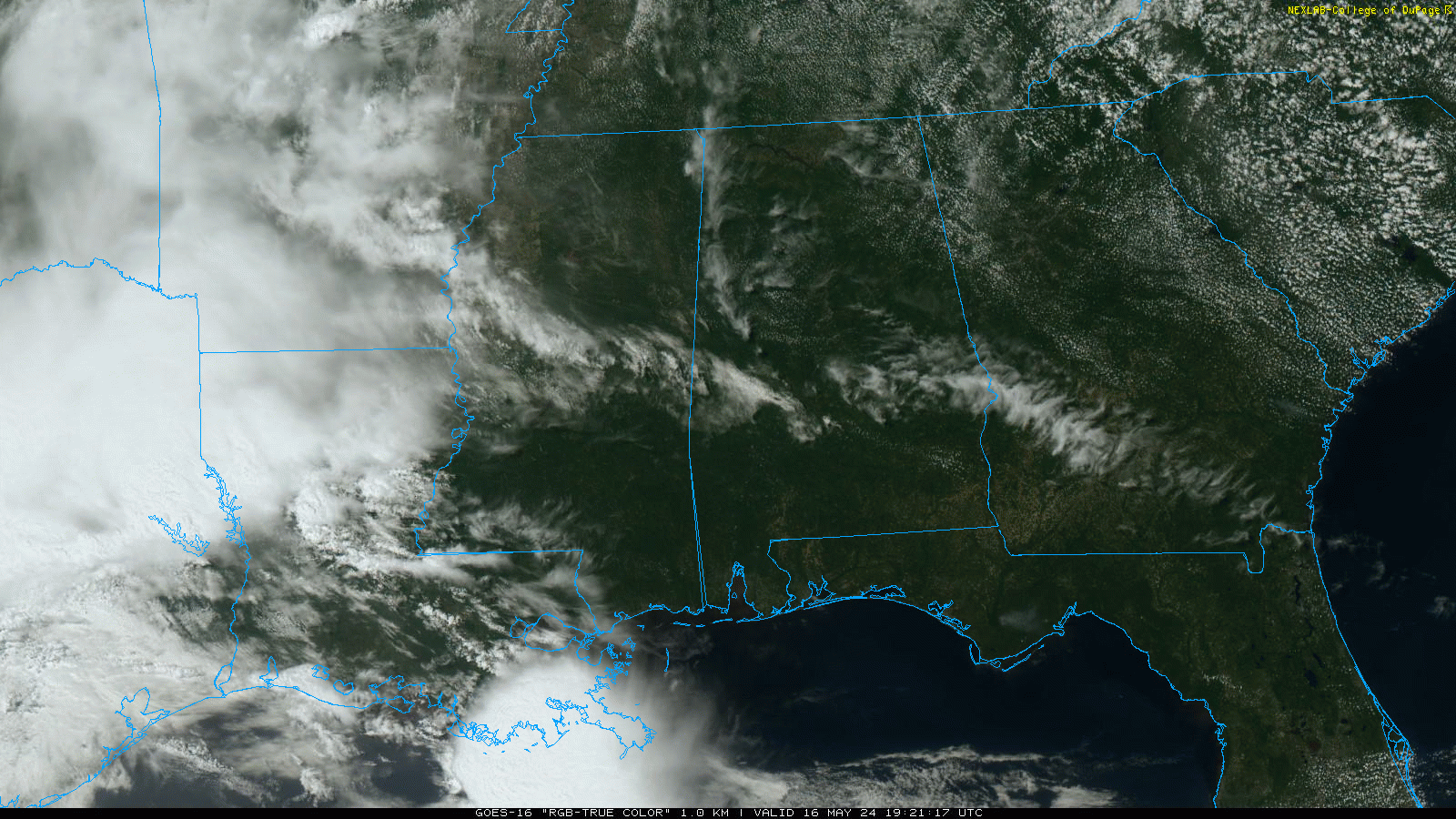
TOMORROW AND THE WEEKEND: Occasional rain and a few thunderstorms are likely across Alabama and the Deep South tomorrow into Saturday. The first batch of rain will arrive early tomorrow morning; heavier storms are possible near the Gulf Coast. Several additional waves of rain/thunderstorms will continue through the afternoon and tomorrow night, but it certainly won’t rain all day and all night. SPC has amended their forecast; the “slight risk” (level 2/5) has been adjusted southward, and includes areas south of a line from Thomasville to Montgomery to Phoenix City. A “marginal risk” (level 1/5) is defined as far north as Hamilton, Pell City, and Wedowee.
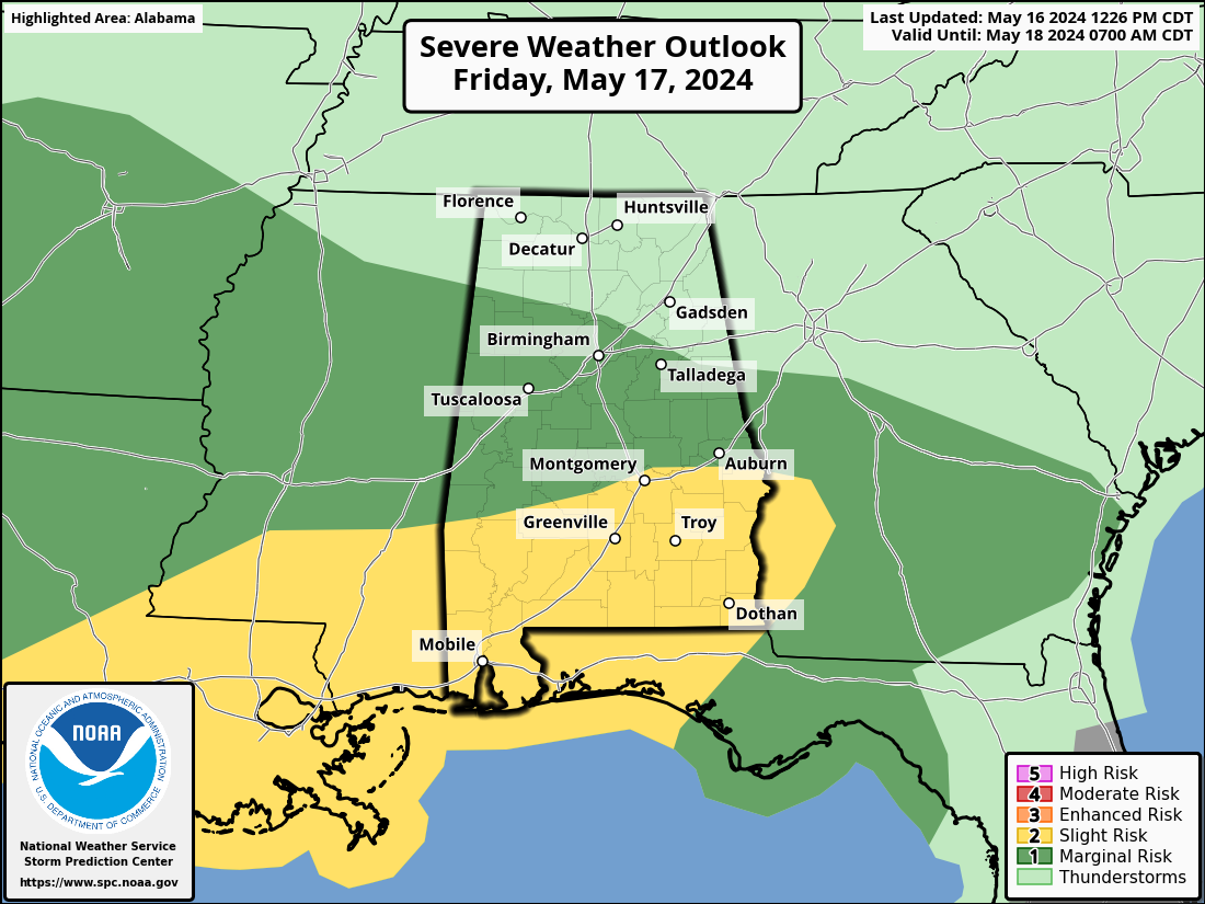
There will be very limited surface based instability over the northern half of the state; the main threat of strong to severe thunderstorms will be across the southern counties through tomorrow night.
The main threat from heavier storms across South Alabama will come from hail and strong, gusty winds. An isolated tornado can’t be ruled out.
Concerning Saturday, again we stress it won’t rain all day, but periods of rain are likely along with some thunder. There is a “marginal risk” (level 1/5) of severe storms over the southeast half of the state. It is almost impossible to say exactly when rain will fall for any given location, but most places will see one to two hours of rain.
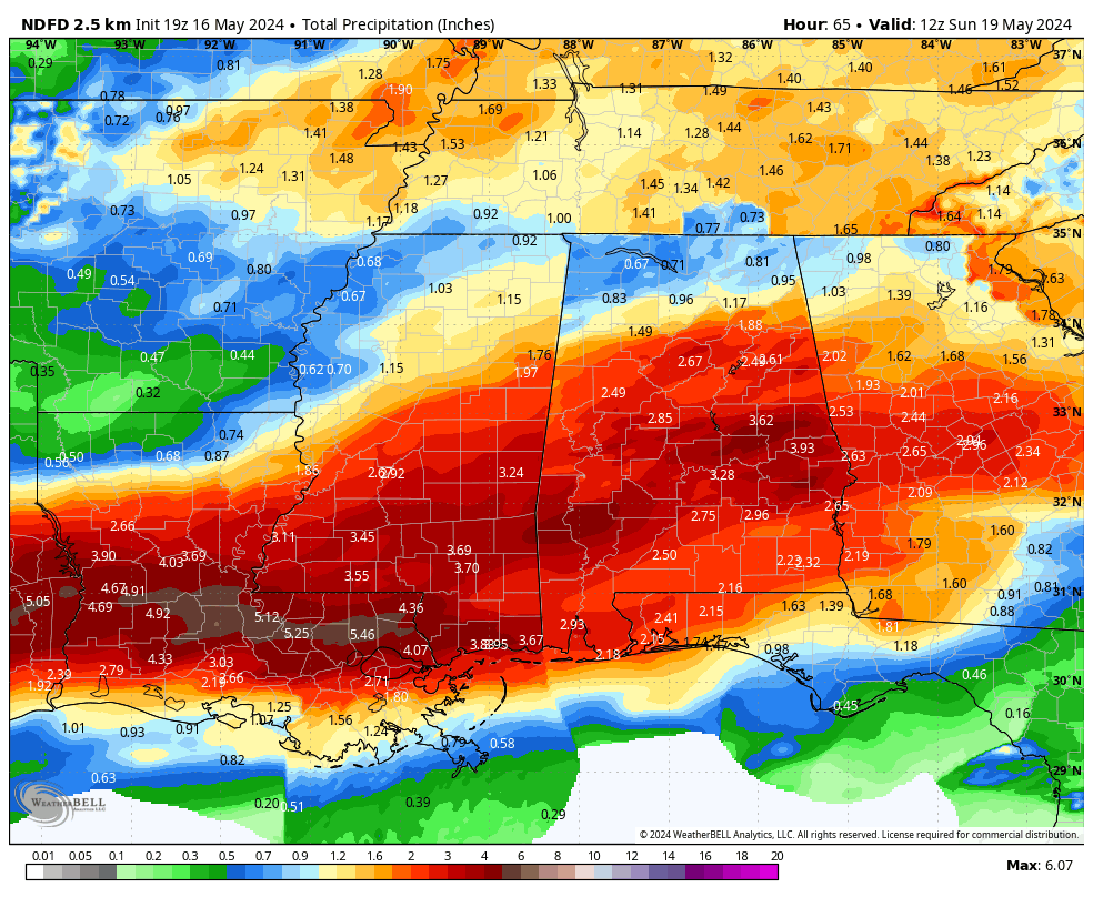
Rain amounts through Saturday night will be in the 2-3 inch rain for much of Alabama, with 1-2 inches for the Tennessee Valley. Some flooding issues are certainly possible in spots over the southern half of the state.
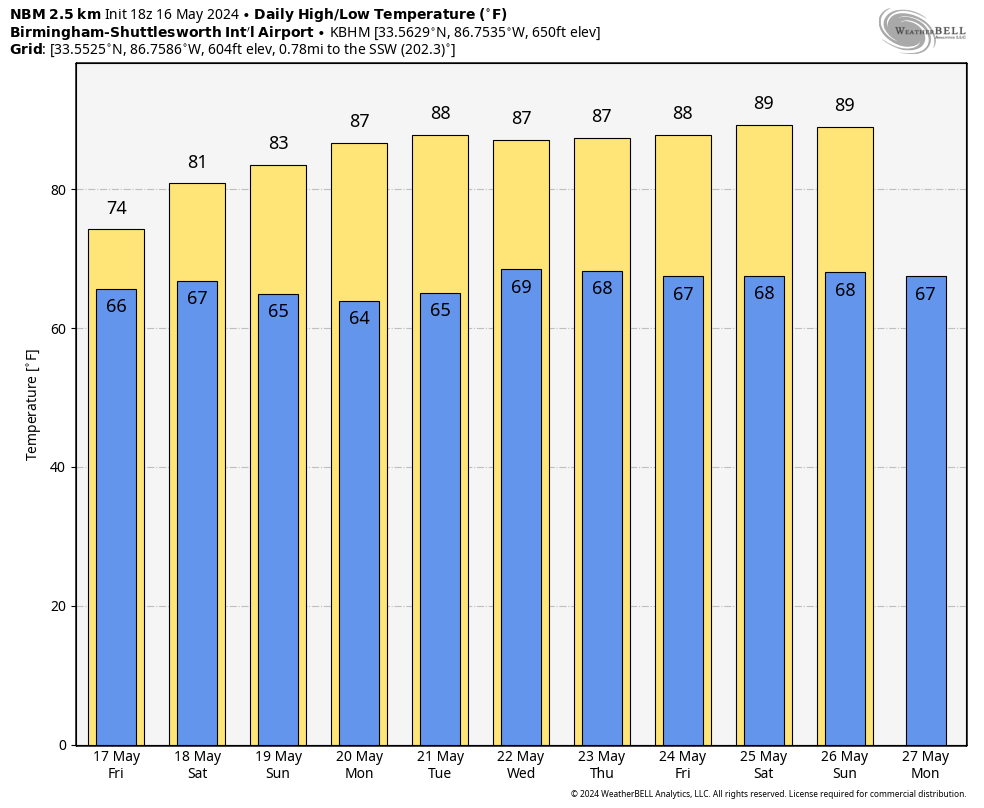
Global models are now hinting that few scattered showers could pop up Sunday morning as an upper low/trough moves overhead; still most of Sunday will be dry with a partly sunny sky along with a high in the mid 80s.
NEXT WEEK: The weather looks generally dry with highs in the 88-92 degree range most afternoons. A weak front could kick off a few isolated showers over North Alabama Wednesday and Thursday, but rain amounts there will be light and spotty. See the video briefing for maps, graphics, and more details.
ON THIS DATE IN 1989: Thunderstorms developing ahead of a cold front produced severe weather in the south-central U.S. Thunderstorms spawned twenty tornadoes, and there were 180 reports of large hail and damaging winds. A tornado in Cleburne, Texas caused thirty million dollars damage. A violent F-4 tornado touched down near Brackettville, Texas and a strong F-3 tornado killed one person and injured 28 others at Jarrell, Texas.
Look for the next video briefing here by 6:00 a.m. tomorrow…
Category: Alabama's Weather, ALL POSTS, Weather Xtreme Videos
About the Author (Author Profile)
James Spann is one of the most recognized and trusted television meteorologists in the industry. He holds the AMS CCM designation and television seals from the AMS and NWA. He is a past winner of the Broadcast Meteorologist of the Year from both professional organizations.Subscribe
If you enjoyed this article, subscribe to receive more just like it.


