1227pm CDT: Intensifying line of storms: Two severe thunderstorm warnings now in effect…
The NWS Hunstville has issued a new severe thunderstorm warning for portions of Marshall and Dekalb Counties until 1pm CDT. A severe warning for southeastern Jackson and central DeKalb Counties continues until 1245pm CDT.
The line of storms from near Winfield to Cullman to Scottsboro and Stevenson has the capability of producing a few areas of severe winds to 60 mph. Torrential rain and frequent lightning occurring. Please be weather aware!
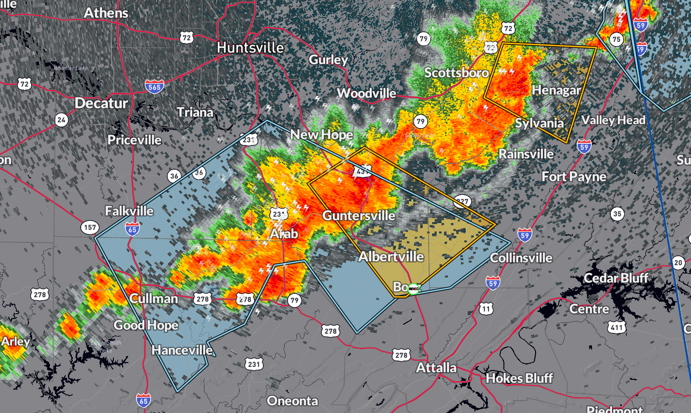
…A SEVERE THUNDERSTORM WARNING REMAINS IN EFFECT UNTIL 1245 PM CDT
FOR SOUTHEASTERN JACKSON AND CENTRAL DEKALB COUNTIES…
At 1223 PM CDT, a severe thunderstorm was located over Pisgah, or 9
miles east of Scottsboro, moving east at 30 mph.
HAZARD…60 mph wind gusts and quarter size hail.
SOURCE…Radar indicated.
IMPACT…Hail damage to vehicles is expected. Expect wind damage to
roofs, siding, and trees.
Locations impacted include…
Henagar, Sylvania, Ider, Pisgah, Dutton, and Rosalie.
…A SEVERE THUNDERSTORM WARNING REMAINS IN EFFECT UNTIL 100 PM CDT
FOR EASTERN MARSHALL AND SOUTHWESTERN DEKALB COUNTIES…
At 1224 PM CDT, a severe thunderstorm was located near Guntersville,
moving southeast at 25 mph.
HAZARD…60 mph wind gusts and quarter size hail.
SOURCE…Trained weather spotters.
IMPACT…Hail damage to vehicles is expected. Expect wind damage to
roofs, siding, and trees.
Locations impacted include…
Albertville, Boaz, Guntersville, Crossville, Geraldine, McVille,
Hopewell, Columbus City, Skirum, and Lake Guntersville St Park.
Category: Alabama's Weather, ALL POSTS, Severe Weather
About the Author (Author Profile)
Owner of Tornado Talk. Radio broadcast meteorologist with The Storm Report. WeatherBrains Panelist. B.S. Meteorology from Penn State University.Subscribe
If you enjoyed this article, subscribe to receive more just like it.


