The Latest on Debby: Rapid Strengthening Forecast; Those Along Florida’s Big Bend Should Push Preparations to Completion!
Tropical Storm Debby now has maximum sustained winds of 65 mph….so it is increasing in intensity and will continue to do so as the environment it is in is very conducive for rapid intensification. The waters are extremely warm and the shear is low. We could have a hurricane on our hands by the end of today. The official NHC forecast calls for the winds to be near 90 mph at landfall near the Florida Big Bend. Residents and visitors in that area need to complete hurricane preparations this afternoon.
Note: The central pressure has dropped to 992 mb compared tot he 7am CDT update which had the pressure at 1001 mb.
Debbie is looking very healthy via satellite imagery. Deeper convection is flaring near the center, which is about 160 miles SSW of Cedar Key, FL.
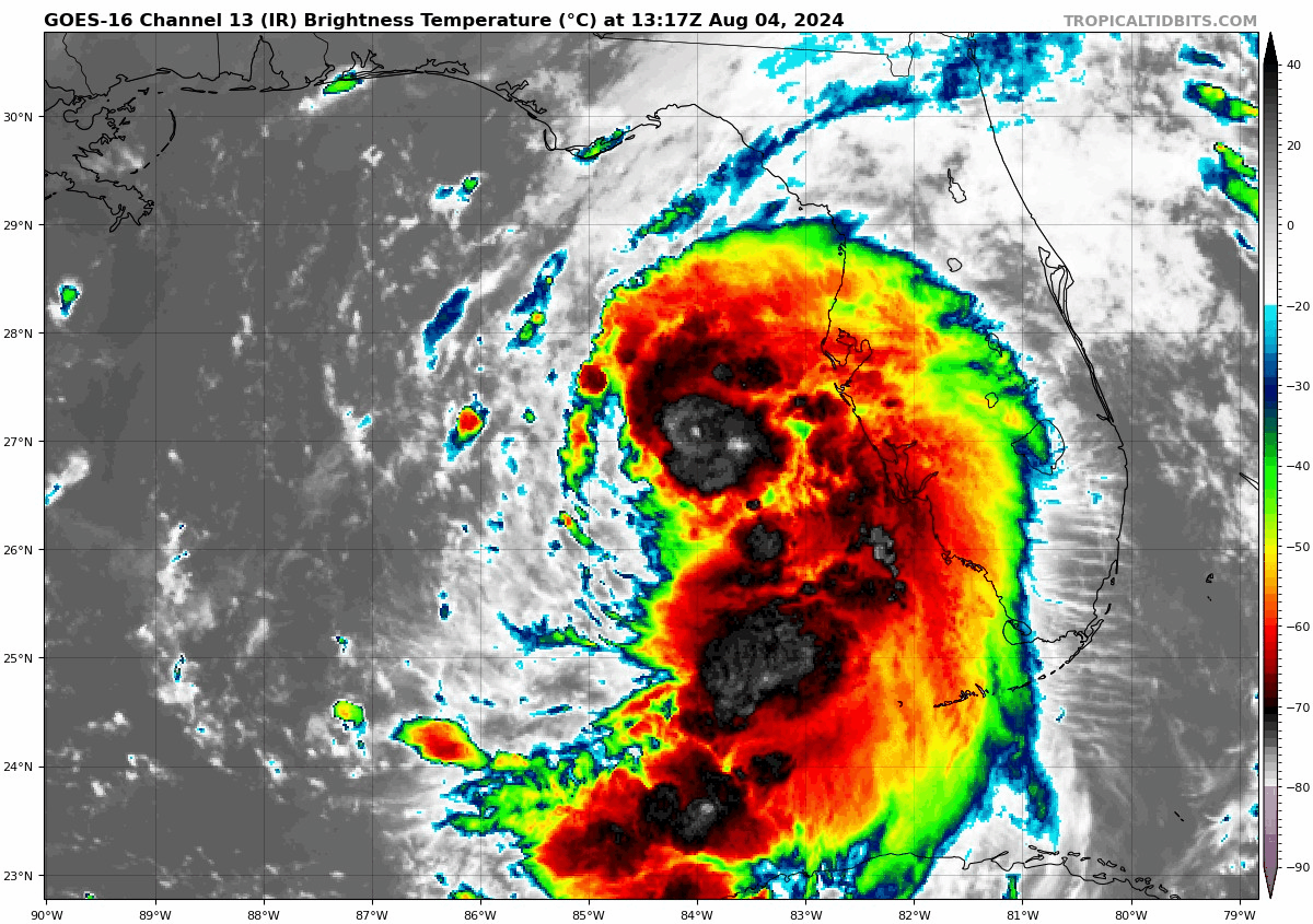
Here are the latest stats from the 10am CDT update:
LOCATION…27.0N 84.3W
ABOUT 130 MI…210 KM WSW OF TAMPA FLORIDA
ABOUT 160 MI…260 KM SSW OF CEDAR KEY FLORIDA
MAXIMUM SUSTAINED WINDS…65 MPH…100 KM/H
PRESENT MOVEMENT…NNW OR 330 DEGREES AT 13 MPH…20 KM/H
MINIMUM CENTRAL PRESSURE…992 MB…29.30 INCHES
Watches and warnings changes with this update:
A Storm Surge Warning has been issued from the middle of Longboat Key to Aripeka, Florida including Tampa Bay.
The Tropical Storm Warning for the Florida Keys east of the Dry Tortugas is discontinued.
The Tropical Storm Watch for the Florida Keys north of the Seven Mile Bridge to the Channel 5 Bridge is discontinued.
Link to all current tropical watches/warnings in effect.
Debby is expected to continue on a north-northwest trek followed by a movement north late today. It will get pulled northeasterly Monday and Tuesday and start to slow down. A landfall near the Florida Big Bend region will occur Monday morning and then Debby will crawl through northern Florida and into southern Georgia.
Here are the storm surge forecasts: Suwannee River to Ochlockonee River, FL…6-10 ft
Yankeetown, FL to Suwannee River, FL…4-7 ft
Ochlockonee River, FL to Indian Pass, FL…4-6 ft
Tampa Bay…3-5 ft
Middle of Longboat Key, FL to Yankeetown, FL…3-5 ft
Bonita Beach, FL to Middle of Longboat Key, FL…2-4 ft
Mouth of the St. Mary’s River to South Santee River, SC…2-4 ft
Charlotte Harbor…2-4 ft
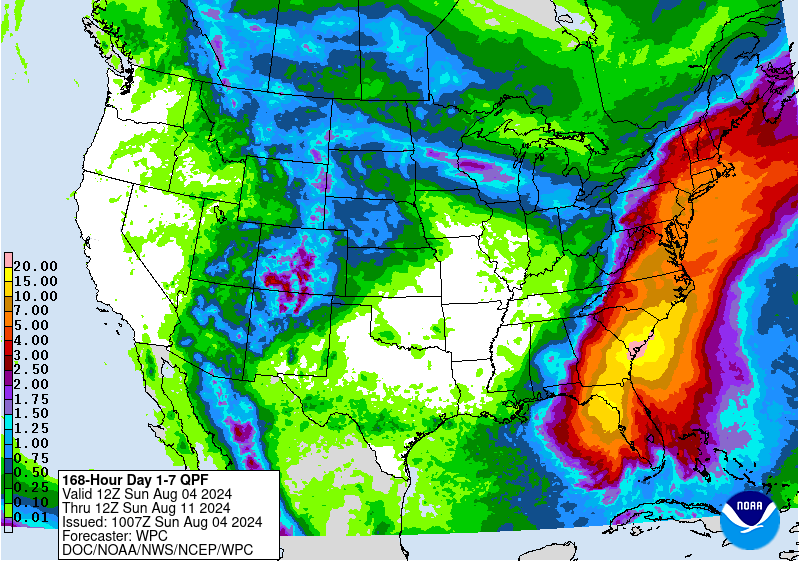
Rainfall: This truly could be a historic flooding events especially for Georgia and South Carolina. Debby could meander around this area through mid-week. 10-20 inches of rain, locally 30 inches a possibility through Friday morning. A general 6-12 inches of rain for the Florida Peninsula with up to 18 inches possible in North Florida.
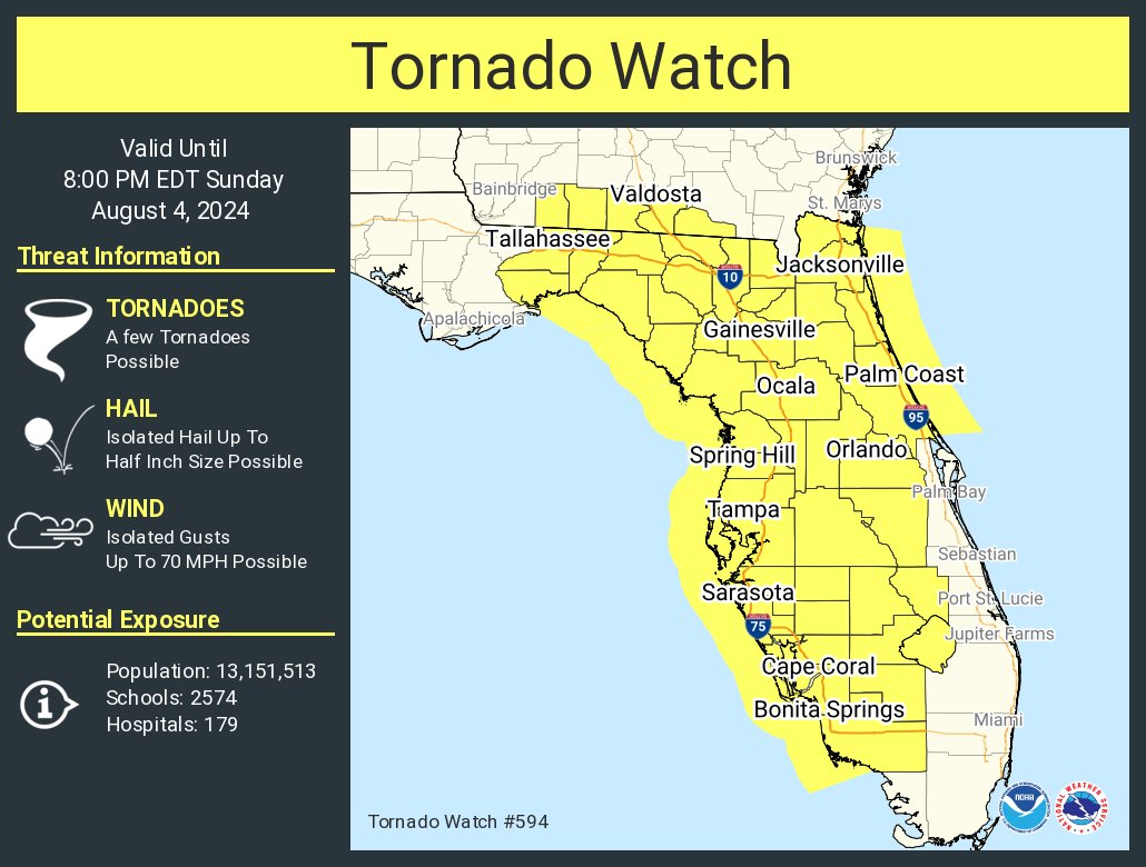
Our first tornado watch for the event has been issued by The Storm Prediction Center for most of Florida. As with most landfalling systems, there is a tornado threat and warnings have been out for a lot of the morning.
About the Author (Author Profile)
Owner of Tornado Talk. Radio broadcast meteorologist with The Storm Report. WeatherBrains Panelist. B.S. Meteorology from Penn State University.Subscribe
If you enjoyed this article, subscribe to receive more just like it.


