1pm CDT Update on Debby: Could Become A Hurricane Tonight; Historic Flooding Possible
We continue to monitor very closely the progress of Tropical Storm Debby, making its way across the eastern Gulf of Mexico. The main impacts for Alabama will be near the coast. Increased swell means and increased rip current risk. With the track staying well to the east of the state, we will be on the drier side of of the circulation around the system. We know a lot of folks have interests in Florida and throughout the southeast and we will continue to bring coverage to you on this blog and on our X channel. Follow us here!
Let’s get down to the latest on Debby:
1pm CDT stats from the NHC:
LOCATION…27.3N 84.4W
ABOUT 125 MI…205 KM WSW OF TAMPA FLORIDA
ABOUT 145 MI…235 KM SSW OF CEDAR KEY FLORIDA
MAXIMUM SUSTAINED WINDS…65 MPH…100 KM/H
PRESENT MOVEMENT…NNW OR 330 DEGREES AT 13 MPH…20 KM/H
MINIMUM CENTRAL PRESSURE…992 MB…29.30 INCHES
No changes with watches and warnings. Rapid strengthening is still forecast and Debby could become a hurricane tonight. The latest hurricane hunter recon is showing max surface winds near 60 mph. Starting to see a more compact inner wind field. Peak seas are up to 18 ft with 15 to 16 ft seas about 25 nautical miles off the FL coast

A special thanks to @NOAA_HurrHunter for providing TAFB with critical significant wave height information in regards to Tropical Storm #Debby! You can see here the data is showing us peak seas are up to 18 ft with 15 to 16 ft seas about 25 nautical miles off the FL coast pic.twitter.com/J8BX18KXr1
— NHC_TAFB (@NHC_TAFB) August 4, 2024
Storm surge flooding has already begun across the southwest Florida coast. This will continue to worsen when Debby begins to pull more northeastward on its way to the Big Bend area.
UPDATE: Tropical Storm #Debby is currently bringing 2 – 4 feet of storm surge to Southwest Florida. These are pictures of flooded Fort Myers Beach right now. Credit: Beach Talk Radio @WINKNews @stormhour @spann pic.twitter.com/kGgwNEiu95
— Matt Devitt (@MattDevittWX) August 4, 2024
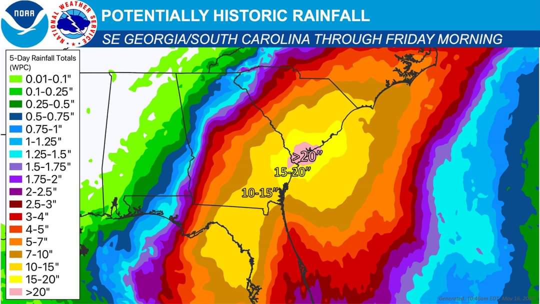
Historic flooding: Starting to see more and more posts about the massive flood potential across Florida, Georgia and South Carolina in the coming days. We have noted it here as well as the models have been consistent at slowing Debby down once it moves inland. The below NWS graphic shows estimated rainfall potential across this area due to Debby.
At this time, we know the states of Florida, Georgia and South Carolina are all under a State of Emergency to prepare for the impacts with Tropical Storm Debby.
About the Author (Author Profile)
Owner of Tornado Talk. Radio broadcast meteorologist with The Storm Report. WeatherBrains Panelist. B.S. Meteorology from Penn State University.Subscribe
If you enjoyed this article, subscribe to receive more just like it.


