Midday Nowcast: Mainly Dry Week; Debby Stays East of Alabama
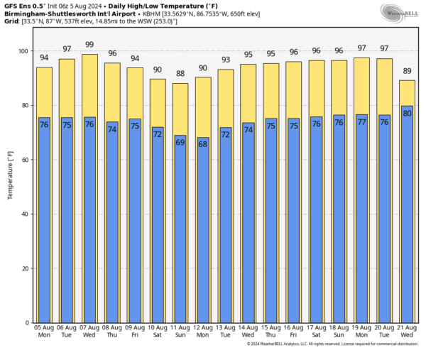
HOT AND DRY: Rain chances are low this week across Alabama, not zero, but generally less than 10% any given day. That means an isolated shower or two will be possible, but the vast majority of us will be dry all week. The days will feature more sunshine than clouds and hot temperatures. Today we are seeing highs in the low to mid 90s, but the rest of the week will feature mid and upper 90s across the state.
BIRMINGHAM ALMANAC: For August 5th, the average high for Birmingham is 91° and the average low is 72°. The record high is 102° set in 1947, while the record low is 59° set in 1950. We average 0.15” of precipitation on this date, and the record value is 1.49” set in 1941.
THE WEEKEND AND BEYOND: The dry pattern continues for the weekend as we expect lots of sunshine Saturday and Sunday with highs in the mid 80s to lower 90s. And, we don’t see much change in the pattern for much of next week. Mainly dry days with only isolated showers and highs in the low 90s. It will be a very quiet period of weather for the state.
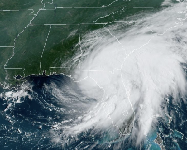
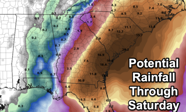
DEBBY STAYING EAST: Debby made landfall this morning at Steinhatchee, Florida. The system is moving into Southern Georgia this afternoon, and is slowing dow as the steering currents collapse. The system will slowly drift east-northeastward as it tracks towards Savannah. Most of the models show Debby moving off the southeast U.S. coast late tomorrow and Wednesday before a ridge builds to the north of the system, which should push it back inland over South Carolina on Thursday. Although the details of the track forecast are unknown, there is high confidence that Debby will move slowly while near or over the southeastern U.S., which will likely result in catastrophic flooding in some locations. Some of the heaviest rain will fall in the zone between Savannah and Charleston, where amounts could exceed 15 inches in spots.
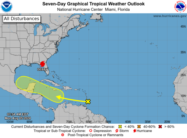
ELSEWHERE IN THE TROPICS: Showers and thunderstorms associated with a tropical wave located near the Windward Islands have decreased and become less organized since yesterday. Any development of this system should be slow to occur during the next couple of days while the system moves westward over the eastern Caribbean Sea. Environmental conditions are expected to become more conducive for development later this week as the system moves across the western Caribbean Sea or the southern Gulf of Mexico. Formation chance through 7 days…low…30 percent. Next name up is Ernesto.
WORLD TEMPERATURE EXTREMES: Over the last 24 hours, the highest observation outside the U.S. was 117.9F at Adrar, Algeria. The lowest observation was -75.6F at Dome A, Antarctica.
CONTIGUOUS TEMPERATURE EXTREMES: Over the last 24 hours, the highest observation was 121F at Death Valley, CA. The lowest observation was 36F at Peter Sinks, UT.
Category: Alabama's Weather, ALL POSTS
About the Author (Author Profile)
Macon, Georgia Television Chief Meteorologist, Birmingham native, and long time Contributor on AlabamaWX. Stormchaser. I did not choose Weather, it chose Me. College Football Fanatic. @Ryan_StinnetSubscribe
If you enjoyed this article, subscribe to receive more just like it.


