Midday Nowcast: Very Hot Hump Day
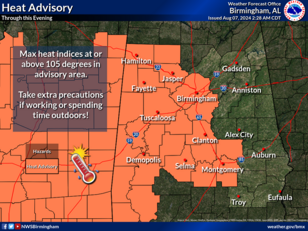
Highs are in the upper 90s and low 100s expected today with a mainly sunny sky across Alabama. For tomorrow and Friday highs return to the mid 90s across much of the state. Rain chances are near zero each day as well, but an isolated, pop-up shower or storm is possible, but not likely. We also note, another Heat Advisory has been issued for portions of Central and West Alabama today as the combination of hot temperatures and high humidity will allow for heat index values to surge to over 105°. This will allow for a quick onset of heat illnesses.
BIRMINGHAM ALMANAC: For August 7th, the average high for Birmingham is 91° and the average low is 72°. The record high is 103° set in 1935, while the record low is 58° set in 1950. We average 0.15” of precipitation on this date, and the record value is 2.58” set in 1952.
THE WEEKEND AND BEYOND: The dry pattern continues for the weekend as humidity levels drop some. We expect lots of sunshine Saturday and Sunday with highs in the mid 80s to lower 90s, while lows will slip down into the 60s. And, we don’t see much change in the pattern for much of next week. Mainly dry days with only isolated showers and highs in the low 90s. It will be a very quiet period of weather for the state.
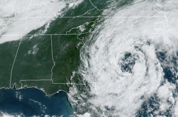
TROPICAL STORM DEBBY: At 1100 AM EDT, the center of Tropical Storm Debby was located near latitude 32.3 North, longitude 79.2 West. Debby is moving toward the northeast near 5 mph. A generally northward motion is expected later today, bringing the center to the South Carolina coast by tonight or early Thursday. A faster motion toward the north and north-northeast across the Carolinas and the U.S. Mid-Atlantic states is expected on Thursday and Friday.
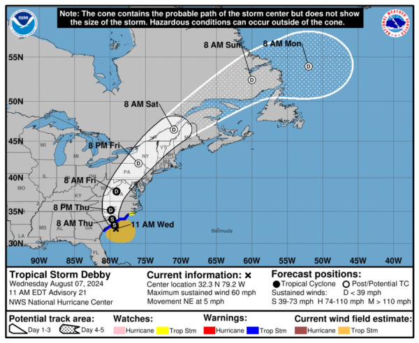
Maximum sustained winds have increased to near 60 mph with higher gusts. Some additional strengthening is possible today or tonight before the center of Debby reaches the coast of South Carolina. Weakening is forecast to begin on Thursday after the center moves inland. Debby is expected to merge with a frontal boundary over the U.S. Mid-Atlantic states on Friday. Tropical-storm-force winds extend outward up to 185 miles from the center. The estimated minimum central pressure is 995 mb (29.39 inches).
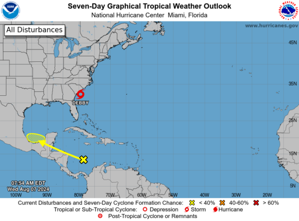
ELSEWHERE IN THE TROPICS: Disorganized showers and thunderstorms located over the southwestern Caribbean sea are associated with a tropical wave. The northern portion of this tropical wave could reach the southwestern Gulf of Mexico over the weekend, however, any development of this system should be slow to occur. Formation chance through 7 days…low…10 percent.
Next name up is Ernesto.
WORLD TEMPERATURE EXTREMES: Over the last 24 hours, the highest observation outside the U.S. was 119.1F at Adrar, Algeria. The lowest observation was -76.0F at Concordia, Antarctica.
CONTIGUOUS TEMPERATURE EXTREMES: Over the last 24 hours, the highest observation was 124F at Death Valley, CA. The lowest observation was 30F at Big Bay, MI.
Category: Alabama's Weather, ALL POSTS
About the Author (Author Profile)
Macon, Georgia Television Chief Meteorologist, Birmingham native, and long time Contributor on AlabamaWX. Stormchaser. I did not choose Weather, it chose Me. College Football Fanatic. @Ryan_StinnetSubscribe
If you enjoyed this article, subscribe to receive more just like it.


