Francine Makes Landfall Later Today; Wind/Rain For Alabama Tonight/Tomorrow
THIS MORNING: Most of Alabama is dry this morning with a mostly cloudy sky. The weather over the next 48 hours will be directly related to Hurricane Francine, which will make landfall this afternoon or this evening on the coast of Louisiana southwest of Baton Rouge/west of New Orleans.
Early this morning Francine has sustained winds of 90 mph, and is centered about 245 miles southwest of Morgan City, Louisiana. It is moving to the northeast at 10 mph.
The structure of Francine could allow for some additional short-term strengthening this morning over the very warm Gulf waters, and this is reflected in the updated NHC forecast. Southwesterly shear is expected to increase over the hurricane later today, and interaction with an upper trough should cause drier air to wrap around the southern portion of Francine as it nears the coast. Thus, the hurricane is not expected to continue strengthening through landfall. Winds should be in the 95-100 mph range at the time the center reaches the Louisiana coast.
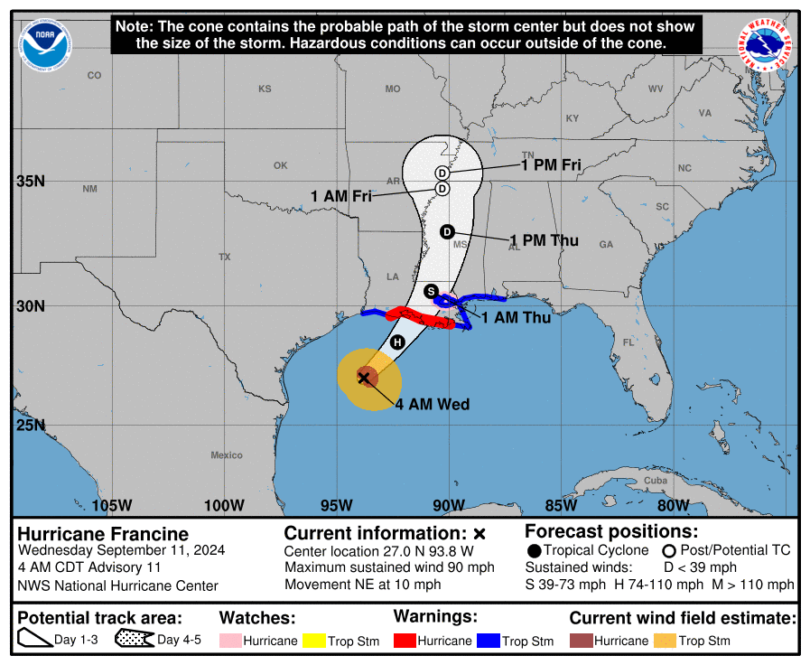
Alabama will be on the wet, unsettled east side of the system. A tropical storm warning remains in effect for the Alabama Gulf Coast. A storm surge of 2-4 feet is forecast for the Gulf Coast of Mobile and Baldwin counties, and Mobile Bay as well.
More about the impact for Alabama tonight and tomorrow:
GRADIENT WIND: Winds could gust as high as 50/55 mph along the Alabama Gulf Coast late this afternoon and tonight. For inland parts of Alabama, gusts to 35/40 mph are possible tomorrow as the circulation of Francine moves northward through Mississippi. A wind advisory will most likely be needed.
RAIN: Rain amounts over Mobile and Baldwin counties will be in the 2-4 inch range, with amounts between 1-3 inches for the rest of the state. Heavier totals will likely be over the western counties. A flash flood watch is in effect for Mobile, Baldwin, and Washington counties in Southwest Alabama.
![]()
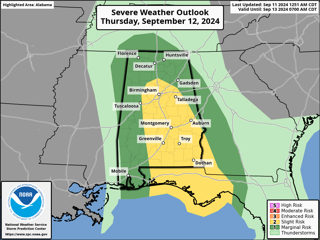
TORNADOES: A few brief, isolated tornadoes can’t be ruled out across the state; SPC has defined a “slight risk” (level 2/5) of severe thunderstorms for the southwest counties of Alabama late today and tonight. Then, tomorrow there is a “slight risk” (level 2/5) for a broad zone from Birmingham to Montgomery to Dothan. The rest of the state is in a “marginal risk” (level 1/5).
Understand tornadoes associated with tropical systems are usually low-topped and short-lived. This makes it very difficult to provide a warning with a long lead time, so be very weather aware tonight and tomorrow and pay attention to warnings.
The weather will improve along the Gulf Coast during the day tomorrow as Francine moves northward. However, a high rip current danger will be in place across the Central Gulf Coast through Friday.
FRIDAY AND THE WEEKEND: The remnant circulation of Francine will likely stall and dissipate northwest of Alabama, and this means some risk of scattered showers and thunderstorms on a daily basis Friday through Sunday. This won’t be a continuous rain, and the sun will be out at times, but just understand some rain is very possible at times. Highs will be in the low 80s.
NEXT WEEK: Scattered showers remain possible Monday, but global models are now trended toward a drier forecast for the rest of the week. Highs will be in the 80s… See the video briefing for maps, graphics, and more details.
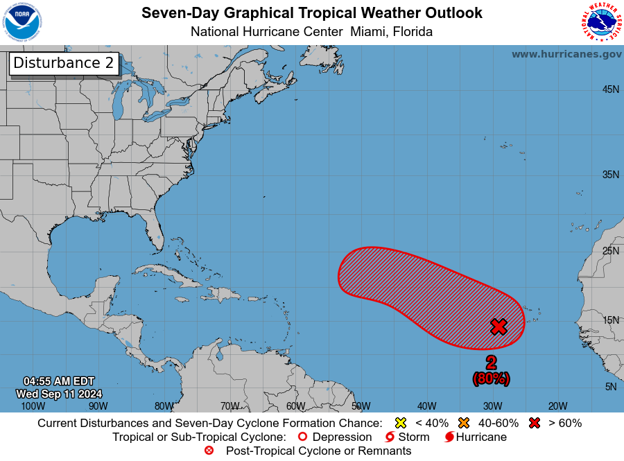
TROPICS: A trough of low pressure over the eastern tropical Atlantic is producing a large but disorganized area of showers and thunderstorms from near the Cabo Verde Islands extending southwestward for several hundred miles. Environmental conditions appear favorable for gradual development of this system, and a tropical depression will likely form during the latter part of this week while the system moves west-northwestward at 10 to 15 mph.
NHC gives this an 80 percent chance of development, but it is far from land and it remains to be seen if any land areas will be impacted. Simply something to watch for now.
ON THIS DATE IN 1961: Hurricane Carla made landfall on the northeast part of Matagorda Island, Texas as a strong Category 4 storm.
ON THIS DATE IN 1992: Hurricane Iniki struck the island of Kaua’i with winds of 145 mph and a central pressure of 27.91 inches of mercury, making it a Category 4 hurricane. Iniki is the strongest hurricane to strike Hawaii Islands in recent history.
Look for the next video briefing here by 3:00 this afternoon… enjoy the day!
Category: Alabama's Weather, ALL POSTS, Weather Xtreme Videos
About the Author (Author Profile)
James Spann is one of the most recognized and trusted television meteorologists in the industry. He holds the AMS CCM designation and television seals from the AMS and NWA. He is a past winner of the Broadcast Meteorologist of the Year from both professional organizations.Subscribe
If you enjoyed this article, subscribe to receive more just like it.


