Midday Nowcast: Rain Returns To Alabama Tomorrow Night; Arctic Blast Arrives Sunday
Today we are seeing sunshine in full supply with afternoon highs in the mid to upper 50s; tonight, lows will be in the upper 20s and lower 30s. Tomorrow, southerly flow begins, allowing temperatures to climb into the upper 50s and lower 60s. Clouds increase tomorrow and a widespread soaking rain will move into Alabama tomorrow night.
BIRMINGHAM ALMANAC: For January 16th, the average high for Birmingham is 54° and the average low is 35°. The record high is 77° set in 1943, while the record low is 7° set in 1972. We average 0.17” of precipitation on this date and the record value is 0.96” set in 1925.
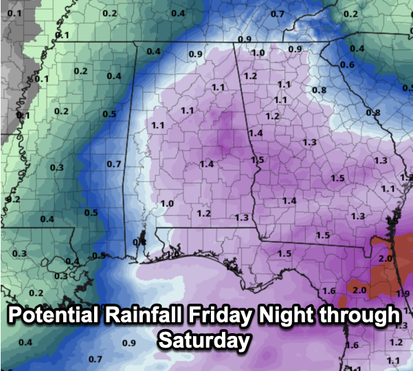
WEEKEND WEATHER: Potential rainfall will be in the 1-2” range statewide from this event, and though some thunder is possible, no severe storms are expected. The rain ends Saturday afternoon, and temperatures will be reach the lower 60s. On Sunday, an Arctic front will come blowing through the state, bringing the coldest air so far this winter to Alabama. Sunday will be very cold with highs holding in the 30s all day across the northern half of the state, add in an icy north wind, and wind chills will likely be in the teens and 20s all day. It will be a mainly cloudy day, and there will be snow flurries flying around in the sky as the moisture departs. Once temperature fall below freezing on Sunday, it will likely be Wednesday or Thursday before temperatures climb back above freezing. Plan now, for a prolonged period of time of sub-freezing temperatures.
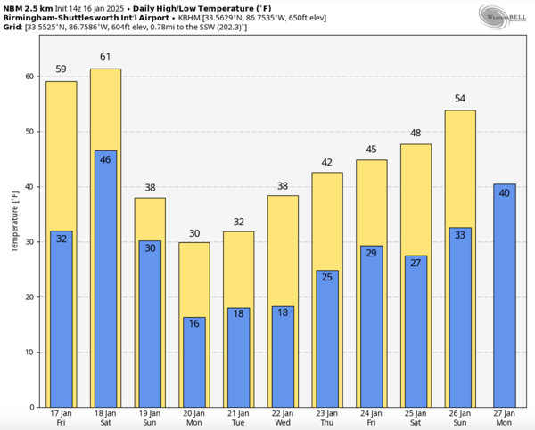
THE ARCTIC TUNDRA: Downright dangerously cold air will be in place across Alabama much of next week. With highs remaining below freezing for the northern half of the state much of the week, you can expect lows in the teens. We know for sure the cold air will be in place, but what about moisture, will it move into Alabama bringing us another round of winter weather precipitation, well that is the unknown.
Looking at model trends, which are not a forecast, we continue to see some potential for a winter storm across the southern U.S. during the mid-week period based on consistent signals from global models. But it is still too early to know any details such as what will we see, where will we see it, and what impacts there could be? Unfortunately, despite what you see on social media, we can’t answer any of those questions now. Highest probabilities of wintry precipitation are in the Tuesday/Wednesday time frame, but the American GFS model continues to suggest the event will come later in the week Thursday or maybe even Friday. And, of course, there is always a chance we see nothing at all as the track of the low will be so far south in the Gulf that Alabama gets very little precipitation.
Hopefully tomorrow we will begin to have some clarity on what we could happen next week, but especially by Sunday we can get specific about potential impacts. Winter storm or not, next week is going to be very cold, and now is the time to prepare for 4-5 days of frigid weather and for now, the very cold weather is the greatest concern.
WORLD TEMPERATURE EXTREMES: Over the last 24 hours, the highest observation outside the U.S. was 110.3F at Rivadavia, Argentina. The lowest observation was -71.0F at Summit, Greenland.
CONTIGUOUS TEMPERATURE EXTREMES: Over the last 24 hours, the highest observation was 79F at Ochopee, FL. The lowest observation was -18F at Gunnison, CO.
Category: Alabama's Weather, ALL POSTS, Social Media
About the Author (Author Profile)
Macon, Georgia Television Chief Meteorologist, Birmingham native, and long time Contributor on AlabamaWX. Stormchaser. I did not choose Weather, it chose Me. College Football Fanatic. @Ryan_StinnetSubscribe
If you enjoyed this article, subscribe to receive more just like it.


