Midday Nowcast: Frigid Temperatures; Incoming Winter Storm For South Alabama
VERY COLD AIR MASS: Frigid weather has settled into Alabama and after morning lows in the teens, highs today will remain below freezing all day. Wind chills remain in teens and 20s this afternoon. Tomorrow and Wednesday the cold air will remain in place with highs in the 30s and lows in the teens. These temperatures are around 20 degrees below average for this time of year. On Thursday, highs should finally climb into the 40s and again on Friday as a gradual warming trend begins.
BIRMINGHAM ALMANAC: For January 20th, the average high for Birmingham is 54° and the average low is 35°. The record high is 78° set in 1928, while the record low is -4° set in 1985. We average 0.16” of precipitation on this date and the record value is 1.73” set in 1979. \
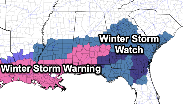
INCOMING WINTER STORM: A winter storm will impact the southern U.S. from Southeast Texas to eastern North Carolina tonight through Wednesday. For Alabama, the snow will come tomorrow mainly over the southern counties of the state. This is where a winter storm warning is in effect tomorrow and tomorrow night. Areas along and south of a line from Demopolis to Selma to Montgomery to Phenix City. The NWS is holding on to a winter storm watch north of the warning area, as far north as Moundville, Centreville, and Wedowee. These areas could be increased to a Winter Weather Advisory for the event tomorrow. This event, is going to be for areas south of Interstate 20.
TIMING: Snow will begin by mid to late morning over Southwest Alabama, becoming widespread during the afternoon and evening hours mainly south of U.S. 80 corridor in the winter storm warning areas. Some communities in the winter warning over South Alabama could see 2-3 inches of snow, including Mobile.
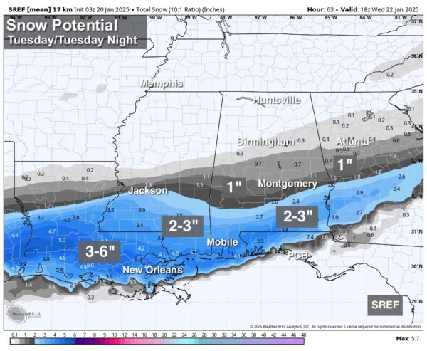
There could even be a few areas that could see totals up to 4 inches down that way. This is one of those rare snow event for Alabama, where the farther south you are in the state, the higher the snow totals will be. The snow should be over by midnight tomorrow night.
IMPACTS: With the very cold air in place and the cold infrastructure, roads will become hazardous quickly where snow falls. Icy travel will continue into Wednesday morning. Temperatures will rise well above freezing South Alabama Wednesday afternoon with some improvement possible, but another freeze is likely Thursday morning with ice still very possible on some roads.
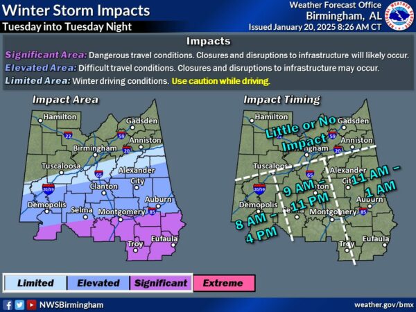
For Central Alabama, light snow is possible in the area where winter storm watch is in places (places like Greensboro, Clanton, Alexander City, and Roanoke), but models have trended southward. Again, in these areas we may see the watch increased to Winter Weather Advisory. For the I-20 corridor (Tuscaloosa, Birmingham, and Anniston) odds are increasing that there will be no snow at all tomorrow. But keep in mind any unexpected northward shift in the Gulf low could bring some light snow, and in this very cold airmass even amounts of 1/4 to 1/2 inch can make roads pretty icy.
We want to remind everyone, even with the system less than 24 hours away, this forecast can change, so watch for updates today, tonight and tomorrow as the event begins.
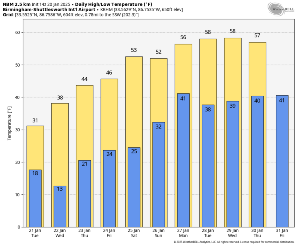
WARMER WEEKEND: While most places will be in the 20s early Saturday morning, highs over the weekend will be in the 50s, very close to seasonal averages for late January. Saturday will be sunny and dry, but Sunday looks to feature increasing clouds with the chance of some scattered rain showers late in the day and into Monday. Good new, next week looks to feature seasonal temperatures; highs in the 50s, lows in the 30s.
WORLD TEMPERATURE EXTREMES: Over the last 24 hours, the highest observation outside the U.S. was 120.7F at Geraldton Airport, Australia. The lowest observation was -66.5F at Delyankir, Russia.
CONTIGUOUS TEMPERATURE EXTREMES: Over the last 24 hours, the highest observation was 88F at Vero Beach, FL. The lowest observation was -42F at Forest Center, MN.
Category: Alabama's Weather, ALL POSTS, Social Media, Winter Weather
About the Author (Author Profile)
Macon, Georgia Television Chief Meteorologist, Birmingham native, and long time Contributor on AlabamaWX. Stormchaser. I did not choose Weather, it chose Me. College Football Fanatic. @Ryan_StinnetSubscribe
If you enjoyed this article, subscribe to receive more just like it.


