Bitterly Cold Air In Place; Winter Storm For South Alabama Tomorrow
FRIGID: Here are temperatures across Alabama early this morning just before sunrise…
Meridianville 12
Fort Payne 13
Haleyville 13
Cullman 14
Huntsville 14
Albertville 14
Decatur 15
Muscle Shoals 16
Gadsden 17
Jasper 18
Birmingham 19
Talladega 19
Pell City 19
Tuscaloosa 20
Anniston 20
Demopolis 21
Greenville 22
Auburn 22
Prattville 23
Mobile 24
Montgomery 24
Atmore 25
Dothan 27
Gulf Shores 28
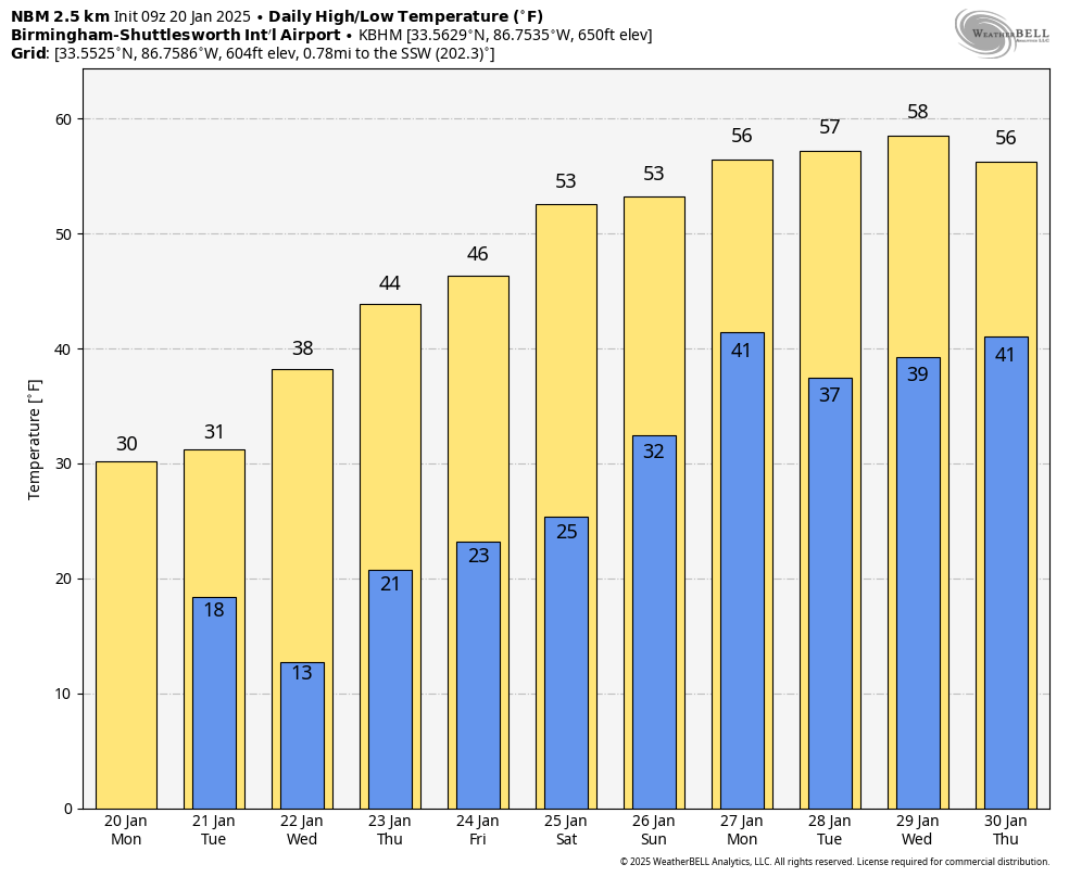
Today will dry with a good supply of sunshine, but temperatures will stay below freezing all day over the northern half of the state.
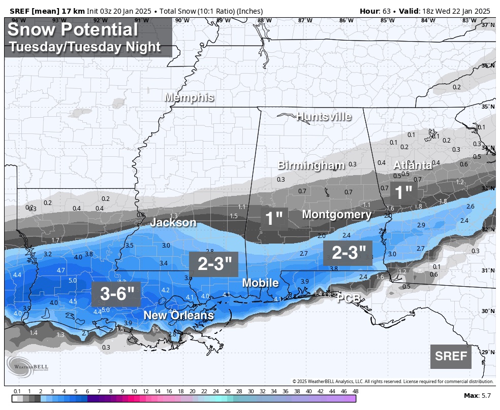
WINTER STORM WARNING: A winter storm will impact the southern U.S. from Southeast Texas to eastern North Carolina tonight through Wednesday. In Alabama, the snow will come tomorrow mainly over the southern counties of the state.
*A winter storm warning is in effect tomorrow for areas south of a line from near Butler to Demopolis to Selma to Montgomery to Phenix City. The NWS is holding on to a winter storm watch north of the warning area, as far north as Moundville, Centreville, and Wedowee.
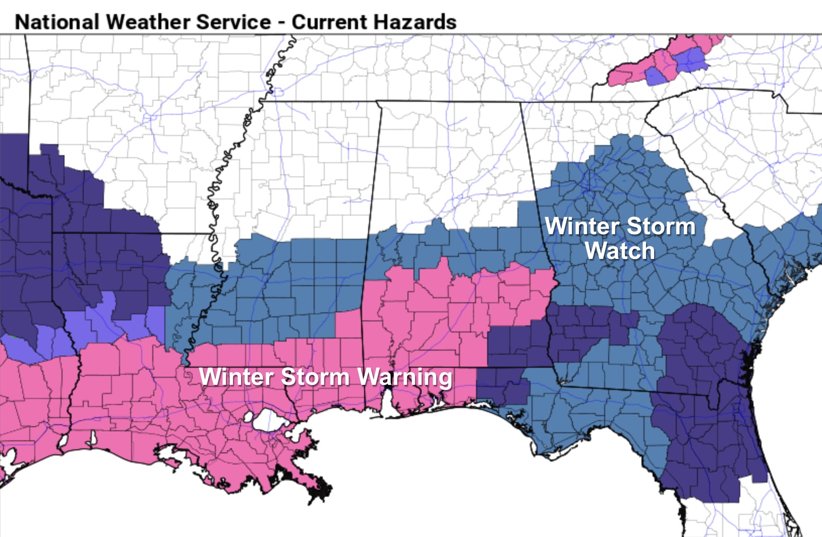
*Snow will begin by mid to late morning over Southwest Alabama, becoming widespread during the afternoon and evening hours mainly south of U.S. 80 over the southern counties of the state. Some communities in the winter warning over South Alabama could see 2-3 inches of snow, including Mobile. The snow should be over by midnight tomorrow night.
*With the very cold air in place and the cold infrastructure, roads will become hazardous quickly where snow falls. Icy travel will continue into Wednesday morning. Temperatures will rise to near 40 degrees across South Alabama Wednesday afternoon with some improvement possible, but another freeze is likely Thursday morning with ice still very possible on some roads.
*Some light snow is possible across parts of Central Alabama where the NWS maintains the winter storm watch (places like Greensboro, Clanton, Alexander City, and Roanoke), but models have trended southward. For the I-20 corridor (Tuscaloosa, Birmingham, and Anniston) odds are increasing that there will be no snow at all tomorrow. But keep in mind any unexpected northward shift in the Gulf low could bring some light snow, and in this very cold airmass even amounts of 1/4 to 1/2 inch can make roads pretty icy.
*Wednesday morning will be the coldest morning this week; lows will be in the teens statewide, and colder spots could dip into the single digits. Thankfully afternoon highs will be in the 40s Thursday and Friday as a warning trend begins.
*Even with the system about 24 hours away, this forecast can change, so watch for updates today.
THE ALABAMA WEEKEND: While most places will be in the 20s early Saturday morning, highs over the weekend will be in the 50s, very close to seasonal averages for late January. Global models suggest rain will return to the state late Sunday, Sunday night, and possibly into Monday.
Temperatures next week look seasonal… See the video briefing for maps, graphics, and more details.
ON THIS DATE IN 1937: The wettest Inaugural Day of record with 1.77 inches of rain in 24 hours. Temperatures were only in the 30s as Franklin D. Roosevelt was sworn in for his second term.
Look for the next video briefing here by 3:00 this afternoon… enjoy the day!
Category: Alabama's Weather, ALL POSTS, Weather Xtreme Videos
About the Author (Author Profile)
James Spann is one of the most recognized and trusted television meteorologists in the industry. He holds the AMS CCM designation and television seals from the AMS and NWA. He is a past winner of the Broadcast Meteorologist of the Year from both professional organizations.Subscribe
If you enjoyed this article, subscribe to receive more just like it.


