Periods Of Rain Through Tomorrow; Dry, Mild Weekend Ahead
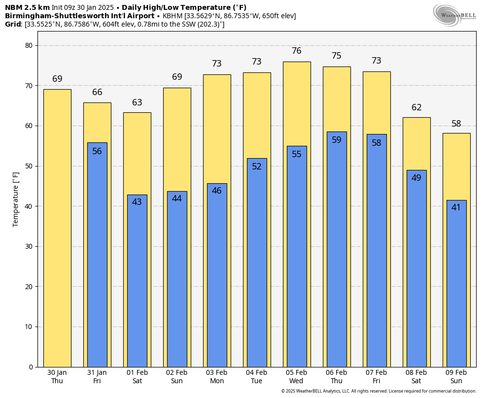
RADAR CHECK: Rain is falling across parts of North Alabama early this morning, mostly north of I-20. This will taper off by mid-morning, and most of the afternoon will be dry with temperatures rising into the 68-73 degree range.
A cold front will push an organized band of showers, and possibly a thunderstorm into the state late tonight into the day tomorrow. With little to no surface based instability, most of Alabama will not have an issue with severe storms, but we note SPC maintains a low end “marginal risk” (level 1/5) for the southeast counties.

Heavier storms over Southeast Alabama tomorrow could produce gusty winds, but most storms will remain below severe limits there with instability very limited. As the upper trough swings through, additional showers will likely develop over North Alabama tomorrow afternoon and tomorrow evening. Those should should be out of the state by 9-10 p.m. The high tomorrow will be in the 60s for most places.
THE ALABAMA WEEKEND: It will be the warmest weekend so far this year with mostly sunny mild days and fair nights. Highs will be in the 60s Saturday, followed by upper 60s and low 70s Sunday.
NEXT WEEK: Models continue to trend warmer; highs will be in the 70s through the week, and some daily record highs could be in danger. The weather will be dry, then we gradually phase in some risk of scattered showers through mid-week. The most widespread rain will likely come at the end of the week with the approach of a cold front. Global models are giving evidence of cooler air returning to the state around February 8-9, but not in the form of an “Arctic blast”… See the video briefing for maps, graphics, and more details.
ON THIS DATE IN 1966: The Blizzard of 1966 impacted New York and paralyzed the region. The train service was disrupted. Numerous highways, the New York State Thruway from Albany to the Pennsylvania state line, and the Buffalo Airport and other airports throughout western and central New York were closed. The Syracuse-Oswego area’s hardest hit, where Bob Sykes, a meteorology professor at the State University of New York at Oswego, reported a whopping 102.4 inches.
ON THIS DATE IN 2013: On the morning of January 30th, 2013, a strong storm system moved across the lower Mississippi River and Tennessee River Valleys. This system not only produced a long-lived squall line or QLCS, but also discrete supercells out ahead of the line. As the storms crossed into Alabama that morning, these thunderstorms caused 5 tornadoes over the northern counties of the state, two areas of significant straight line wind damage and isolated flash and areal flooding. In addition to the severe weather, widespread reports of downed trees caused by pressure gradient winds were received throughout the day.
Look for the next video briefing here by 3:00 this afternoon… enjoy the day!
Category: Alabama's Weather, ALL POSTS, Weather Xtreme Videos
About the Author (Author Profile)
James Spann is one of the most recognized and trusted television meteorologists in the industry. He holds the AMS CCM designation and television seals from the AMS and NWA. He is a past winner of the Broadcast Meteorologist of the Year from both professional organizations.Subscribe
If you enjoyed this article, subscribe to receive more just like it.


