Midday Nowcast: Wet and Stormy Wednesday; Greatest Severe Weather Threat Across South Alabama
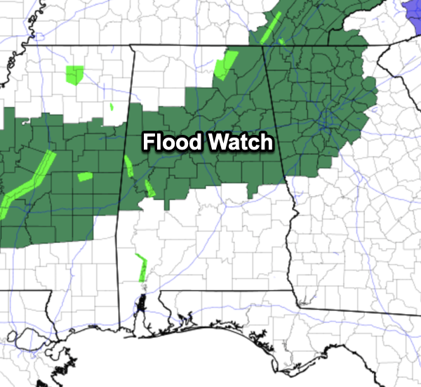
WET AND STORMY DAY: A flood watch is in effect for parts of Central and Northeast Alabama through tonight, where rain amounts of 2-3 inches are possible and we think the threat of flooding is the bigger threat across the northern half of the state today.
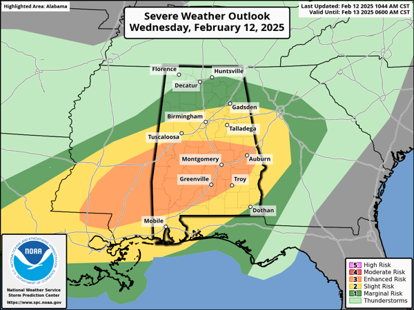
There remains the threat of strong and severe storms this afternoon and tonight. The SPC has defined an “enhanced risk” (level 3/5) over south and southwest Alabama, along and south of a line from Moundville to Jemison to Alexander City, some cities included are Demopolis, Selma, Montgomery, Auburn, Greenville, Troy, Monroeville, and Thomasville. A “slight risk” (level 2/5) of severe thunderstorms as far north as Tuscaloosa, Birmingham, and Gadsden…a “marginal risk” (level 1/5) is in place as far north as Huntsville.
At the writing of this forecast, it is cool and wet across much of North/Central Alabama, which is no supportive of severe storms. However, there is a well defined warm front across South Alabama, and today’s forecast and northward extent of severe weather threat will depend on how far north the warm front will move. With the rain cooled air across the northern half of the state, it is going to be hard to get the front to move northward and the high resolution models still show the front having a tough time of the U.S. 80 corridor across Central Alabama.
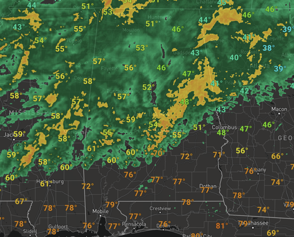
From the get go, we have said and still believe the highest risk of severe storms will be over the southern half of Alabama this afternoon and tonight. Storms over South Alabama this afternoon and tonight will be capable of producing strong winds, and a few isolated tornadoes are possible. For the rest of us in North and Central Alabama, as always you still need to pay close attention to the weather in case the warm front moves farther north, which would allow for the a greater chance of severe weather farther north. Temperatures today will range from the low to mid 50s across the Tennessee Valley to the 70s over the southern counties.
BIRMINGHAM ALMANAC: For February 12th, the average high for Birmingham is 58° and the average low is 38°. The record high is 78° set in 1922, while the record low is 5° set in 1899. We average 0.17” of precipitation on this date and the record value is 2.40” set in 1900.
TOMORROW/FRIDAY: The rain will come to an end early tomorrow as drier air moves into the state. We expect a clearing sky with highs in the 50s. Friday will be rain-free and mostly sunny with afternoon highs in the low 60s. Lows will be in the 30s with some 20s expect Friday morning.
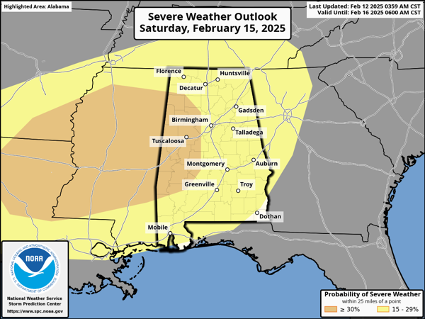
MORE STORMS THIS WEEKEND: A very dynamic system will bring rain and thunderstorms back to Alabama. This is a system we are going to have to watch very carefully as the potential severe weather threat is increasing with it. The SPC has defined a risk for most all of Alabama, with an enhanced risk for the western counties of the state in their “Day 4” outlook, which runs from Saturday through 6AM Sunday. This set-up looks more like classic severe weather event we see this time of year across the Deep South.
A warm front will surge northward Saturday making for a warm and breezy day as temperatures rise into the 70s. Most of the day will be dry, but the air will become unstable ahead of the approaching system. Severe storms will develop to our west during the afternoon and evening hours, and these will move into Alabama during the overnight hour and predawn hours of Sunday as an organized batch of rain and storms. All modes/types of severe weather will be possible, tornadoes, damaging winds, and hail.
Again, one system at a time, let’s get through today’s threat before we focus on the weekend and the specific about the magnitude of the event, the timing, and the tornado threat.
The sky becomes mostly sunny and it will be cooler Sunday with a high in the 50s. Sunday night lows will fall into the 20s across much of North and Central Alabama. It looks like another round of heavy rain returns to the state by the middle of the week and again, flooding issues could develop.
WORLD TEMPERATURE EXTREMES: Over the last 24 hours, the highest observation outside the U.S. was 118.0F at Oodnadatta Airport, Australia. The lowest observation was -56.6F at Vostok, Antarctica.
CONTIGUOUS TEMPERATURE EXTREMES: Over the last 24 hours, the highest observation was 90F at McAllen, TX. The lowest observation was -47F at Peter Sinks, UT.
Category: Alabama's Weather, ALL POSTS, Severe Weather, Social Media
About the Author (Author Profile)
Macon, Georgia Television Chief Meteorologist, Birmingham native, and long time Contributor on AlabamaWX. Stormchaser. I did not choose Weather, it chose Me. College Football Fanatic. @Ryan_StinnetSubscribe
If you enjoyed this article, subscribe to receive more just like it.


