Midday Nowcast: Sunny Days Through the Weekend; Strong Storms Possible Early Wednesday Morning
THROUGH THE WEEKEND: Expect sunshine in full supply today through Sunday. Highs will be in the mid to upper 60s today and tomorrow, but cooler air slips into Alabama on Sunday with highs mainly in the upper 50s. Lows will drop into the mid 30s by Sunday and Monday mornings.
BIRMINGHAM ALMANAC: For February 28th, the average high for Birmingham is 63° and the average low is 42°. The record high is 82° set in 2021, while the record low is 17° set in 2002. We average 0.19” of precipitation on this date and the record value is 1.81” set in 1903.
ACROSS THE USA: Heavy snow expected near the U.S. Canadian border from the Northern Great Plains to Maine. Temperatures will be 10 to 20 degrees below average behind a strong cold front across the Midwest and Ohio Valley on Saturday. An Elevated Risk of fire weather conditions over parts of the Plains on Friday.
NEXT WEEK: Not much change in the forecast for next week as we watch and wait for the threat of severe storms for early Wednesday morning across Alabama. Monday will feature more clouds than sun with highs in the 60s. On Tuesday, a few scattered showers are possible as the dynamic storm causes severe weather to our west.
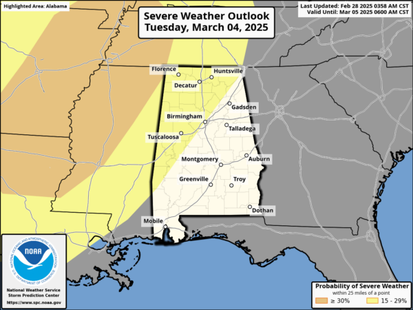
The Storm Prediction Center (SPC), continues to define a risk of severe storms for the Lower Mississippi Valley and that extends into portions of Alabama as a band of strong possibly severe storms will move through the state during the pre-dawn hours Wednesday. For now the timing for this line will be from 3AM-10AM Wednesday and the line of severe storms will have the with potential for damaging winds and few isolated tornadoes. Thankfully the storms will come through at a time when the air tends to be more stable, but this system has very strong wind fields and strong dynamics can often overcome weak thermodynamics. We still have several days to watch this threat and will be much more specific about this event as it gets closer. Let us worry about the system for now, and everyone should enjoy the great weather this weekend. Rain amounts will be in the 1-2 inch range for the northern half of the state, with 1/2 to 1 inch for South Alabama.

Drier air will move into the state for the second half of the week being the storm system. High next week will be in the 60s and 70s.
WORLD TEMPERATURE EXTREMES: Over the last 24 hours, the highest observation outside the U.S. was 112.5F at Birdsville Airport, Australia. The lowest observation was -67.4F at Vostok, Antarctica.
CONTIGUOUS TEMPERATURE EXTREMES: Over the last 24 hours, the highest observation was 93F at Santa Ana, CA. The lowest observation was -20F at Peter Sinks, UT.
Category: Alabama's Weather, ALL POSTS, Social Media
About the Author (Author Profile)
Macon, Georgia Television Chief Meteorologist, Birmingham native, and long time Contributor on AlabamaWX. Stormchaser. I did not choose Weather, it chose Me. College Football Fanatic. @Ryan_StinnetSubscribe
If you enjoyed this article, subscribe to receive more just like it.


