Midday Nowcast: Clearing Sky Today; Severe Storms Expected Saturday
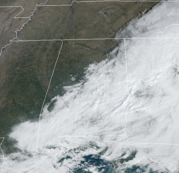
The rain has ended and the sky is clearing across the state this afternoon; temperatures this afternoon are generally in the low and mid 60s. Tonight, expect a clear and chilly night with lows in the upper 30s to lower 40s.
BIRMINGHAM ALMANAC: For March 10th, the average high for Birmingham is 65° and the average low is 44°. The record high is 85° set in 1974, while the record low is 16° set in 1932. We average 0.18” of precipitation on this date and the record value is 4.69” set in 2000.
USA BRIEF: A low pressure system will move into the Atlantic today while producing scattered showers and thunderstorms across the Southeast. Conditions should improve on Tuesday. Meanwhile, a potent low pressure system will dip into the northern tier states today, bringing strong winds and the potential for fires to the region. Ahead of this system, warm southerly flow will support unseasonably warm temperatures in the 50s and 60s with some isolated areas possibly exceeding 70 degrees. These temperatures are 20-40 degree above average for much of the Northern/Central Plains and Upper Midwest, where widespread records may be tied or broken. The arrival of the attendant cold front this afternoon/evening will moderate temperatures as well as increase potential for fires. The Storm Prediction Center issued a Critical Risk of Fires for much of the Dakotas where dry and windy conditions will support wildfires
SPLENDID SPRING DAYS: The next two days are going to be gorgeous across Alabama with sunshine in full supply and comfortable afternoon temperatures. Expect highs in the low and mid 70s both days, while nights will be chilly with lows in the 40s. On Thursday, a quick moving disturbance will bring showers back to Alabama. A thunderstorm is also possible, but for now we are not expecting any severe storms. Rain amounts Thursday should be generally under 1/2 inch. Friday looks dry and warm with highs ranging from the upper 70s to lower 80s.
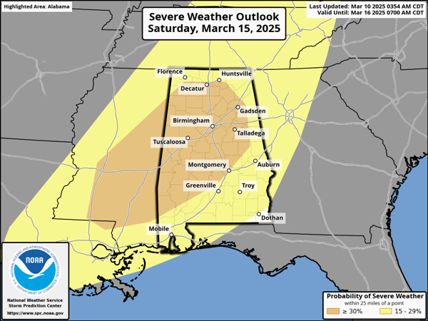
SEVERE STORM THREAT SATURDAY: A very dynamic storm system will bring the threat of severe thunderstorms to the Deep South this weekend.
Actually, on Friday, severe storms are expected to our west throughout the Mississippi Valley up into the Great Lakes. This system and the severe weather threat will shift east into Alabama on Saturday and Saturday night.
The Storm Prediction Center (SPC) has already defined an “enhanced risk” (level 3 of 5) of severe storms over much of Alabama Saturday. This threat level is likely to change in the coming days.
Confidence is high the synoptic scale pattern (large scale) will be very supportive of severe weather. What we don’t know yet is how the mesoscale features (small scale) will impact the event. These will come into play starting mid-week. These mesoscale feature will determine the magnitude and impacts of the event.
THREATS: All modes of severe weather will be possible Saturday and Saturday night, including hail, damaging winds, and tornadoes. In addition, gradient winds will be an issue as well (not related to thunderstorms). Ahead of the storm system, Friday night and Saturday strong southerly winds will be howling north into the system. Much like the last system, these winds are likely to cause power issues.
It will not rain all day Saturday, but several rounds of storms are possible. We will be much more specific about timing later this week. This is the core of our severe weather season in Alabama, which runs from November to May, with March and April the most active months, events like this are not uncommon. Many of you have anxiety about severe weather, especially those that have gone through tornadoes or other kinds of violent weather. Have comfort knowing that even on the biggest severe weather days, odds of any one home being hit by a tornado are very low. But, you have to pay attention and be prepared. We will get through the event together.
AFTER THE STORMS: Dry air returns Sunday; highs over the weekend will be in the 70s. The first half of next week looks dry and mild; rain and storms are likely to return by Thursday or Friday. Typically, this time of year, you will get into a 5-7 day storm cycle, meaning for the next several weeks, you can expect the threat of rain and storms at least once a week.
TOTAL LUNAR ECLIPSE THURSDAY NIGHT: The Moon will pass into Earth’s shadow and appear to turn red on late Thursday night and into the early morning hours of Friday.
In a total lunar eclipse, the entire Moon falls within the darkest part of Earth’s shadow, called the umbra. When the Moon is within the umbra, it appears red-orange. Lunar eclipses are sometimes called “Blood Moons” because of this phenomenon. You don’t need any special equipment to observe a lunar eclipse, although binoculars or a telescope will enhance the view. A dark environment away from bright lights makes for the best viewing conditions.
For Birmingham (and for most of Alabama), totality will begin at 1:26 AM CDT Friday March 14, ending at 2:31AM CDT. We are expecting clouds and showers Thursday, but there is a chance clouds will move out by the time of the eclipse.
WORLD TEMPERATURE EXTREMES: Over the last 24 hours, the highest observation outside the U.S. was 110.8F at Tillabery, Niger. The lowest observation was -79.6F at Vostok, Antarctica.
CONTIGUOUS TEMPERATURE EXTREMES: Over the last 24 hours, the highest observation was 91F at Hollywood, FL. The lowest observation was -2F at Bondurant, WY.
Category: Alabama's Weather, ALL POSTS, Social Media
About the Author (Author Profile)
Macon, Georgia Television Chief Meteorologist, Birmingham native, and long time Contributor on AlabamaWX. Stormchaser. I did not choose Weather, it chose Me. College Football Fanatic. @Ryan_StinnetSubscribe
If you enjoyed this article, subscribe to receive more just like it.


