Midday Nowcast: Some Storms Today; High Impact Severe Weather Outbreak This Weekend
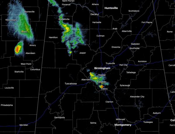
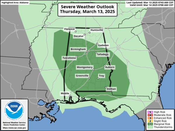
SOME STORMS TODAY: A quick moving system is bringing rain and some storms back to Alabama. The Storm Prediction Center (SPC) maintains a “marginal risk” (level 1 of 5) for severe storms this afternoon across much of Alabama.
A few severe storms are possible today, and these storms could produce gusty winds and hail, but the overall threat is low due to lack of dynamic support. We note, there is a non-zero threat of an isolated tornado across southern sections of the state. Rain amounts should be generally under 1/2 inch and highs tomorrow will be in the lower 70s.
BIRMINGHAM ALMANAC: For March 13th, the average high for Birmingham is 66° and the average low is 44°. The record high is 84° set in 1900, while the record low is 12° set in 1993. We average 0.18” of precipitation on this date and the record value is 2.72” set in 1975.
TOTAL LUNAR ECLIPSE TONIGHT: The Moon will pass into Earth’s shadow and appear to turn red on late Thursday night and into the early morning hours of Friday.

In a total lunar eclipse, the entire Moon falls within the darkest part of Earth’s shadow, called the umbra. When the Moon is within the umbra, it appears red-orange. Lunar eclipses are sometimes called “Blood Moons” because of this phenomenon. You don’t need any special equipment to observe a lunar eclipse, although binoculars or a telescope will enhance the view. A dark environment away from bright lights makes for the best viewing conditions.
At Birmingham (and for most of Alabama), totality will begin at 1:26 AM CDT Friday March 14, ending at 2:31AM CDT. We are expecting clouds and showers Thursday, but hopefully clouds will move out by the time of the eclipse.
FOR FRIDAY: Tomorrow will feature a mix of and sun and clouds, warm temperatures, and breezy conditions; highs will range from the upper 70s to lower 80s. However, severe storms will move into Alabama Friday night.
GRADIENT WINDS: Non-thunderstorm winds ahead of the storm system Friday through Saturday will be howling north into the system. Much like the last system, these winds are likely to cause power issues.
SEVERE WEATHER OUTBREAK THIS WEEKEND: Alabamians will need to pay very close attention to the weather tomorrow night through Saturday night as a dynamic storm system will bring violent thunderstorms to the state. We are going to have two rounds of severe storms impact Alabama this weekend. The first will occur Friday night and into early Saturday. The second, and more impactful event, will occur Saturday afternoon and night.
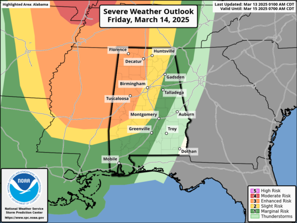
ROUND ONE: The SPC has much of the state in the threat of severe storms for Friday night into Saturday, with an “enhanced risk” (level 3 of 5) for wester portions of the state. Hail, damaging winds, and a few tornadoes are possible. With this round occurring during the overnight hours, make sure you have ways to receive severe weather alerts.
ROUND TWO: This will be the main and greater event of the weekend. The (SPC) has increased the risk of severe weather to a “moderate risk” (level 4 of 5) of severe storms for most of Alabama, with an “enhanced risk” (level 3 of 5) for the rest of the state for Saturday afternoon into Saturday night. Again, already having a moderate risk three days out, we may see the risk increased to the highest level (5 out of 5) on Saturday. Plan now and new ready for a significant and high impact severe weather event for Alabama.
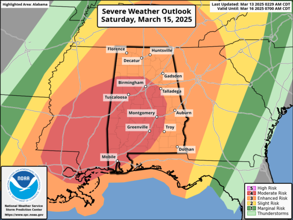
TIMING: For now, this round will occur from 12PM noon Saturday through 3AM Sunday morning.
THREATS: Storms will be capable of producing large hail, damaging winds, and tornadoes. Strong (EF2+), long-track, violent tornadoes are possible as well. These storms should be out of the state by daybreak Sunday. Rainfall amounts will be in the 2-3 inch range for the northern half of the state, with 1-2 inches across the southern sections of the state. We could see some areas of isolated flooding develop.
At AlabamaWX, you will never get fear mongering or overhyping, but a clear understanding of the potential threats, especially when it comes to high impact events. We want to make sure that our forecast and discussions relay the adequate threats and impacts with each event, but we also want to make sure everyone understands the seriousness of the event. Our goal for any severe weather event in Alabama is no loss of life, and no serious injuries. It takes us all working together to make that happen.
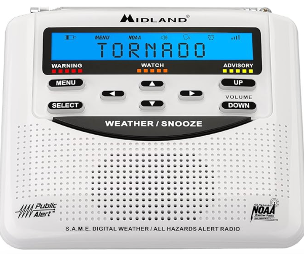
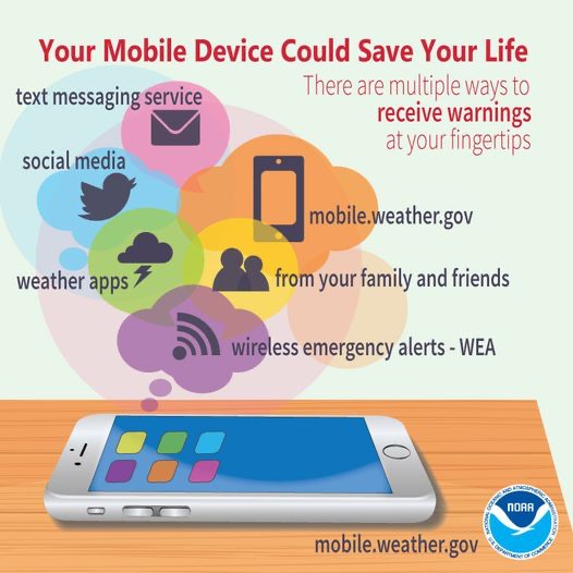
CALL TO ACTION: With any severe weather event, be ready to act immediately…Have multiple, reliable ways to receive severe weather alerts, NEVER, ever, ever rely on a outdoor siren. Every Alabama home and business needs a NOAA Weather Radio (the most popular model is the Midland WR-120, which is sold in most local big box retailers).
The other way is your phone…be sure emergency alerts are enabled (look under settings, and notifications), and install the free ABC 33/40 Weather app.
Know the safe place in your house, and in that safe place have helmets for everyone. Bicycle helmets and batting helmets work well. We also recommend portable air horns and hard soled shoes for everyone. If you live in an apartment complex, you can’t be above the first level. Shelter with a friend on the ground level, or ask management if they can open the clubhouse during a tornado warning.
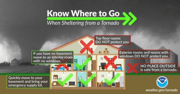
If you live in a mobile home, you cannot stay there during a tornado warning, they offer little to know protection from severe storms. Know the location of the nearest shelter, or business that is open 24/7. Know how to get there quickly.
Subscribe to the James Spann and ABC 33/40 YouTube channels so you can watch our live coverage. We are thankful for the out of state YouTubers who do long form severe weather coverage, but to be truly successful in reaching people and communicating warnings in high end severe weather events like this, you have to understand the people, culture, geography, and microclimate of the region impacted.
BE A HERO: You can help us. Tell your friends, neighbors, and relatives about the threat, and what they need to do to get ready. And, if they fall in a tornado warning polygon, call them or text them to let them know about the threat. You are our most valuable resource in spreading the word!
Again, this is the core of our severe weather season in Alabama, so events like this are not uncommon. Many of you have anxiety about severe weather, especially those that have gone through tornadoes or other kinds of violent weather. Have comfort knowing that even on the biggest severe weather days, odds of any one home being hit by a tornado are very low. But, you have to pay attention and be prepared. We will get through the event together.
AFTER THE STORMS: Dry air returns Sunday; highs will be in the 60s and 70s. The first half of the following week looks dry and mild; rain and storms are likely to late Wednesday, for now it does’t look like a severe weather threat.
WORLD TEMPERATURE EXTREMES: Over the last 24 hours, the highest observation outside the U.S. was 111.6F at Tillabery, Niger. The lowest observation was -73.1F at Amundsen-Scott South Pole Station, Antarctica.
CONTIGUOUS TEMPERATURE EXTREMES: Over the last 24 hours, the highest observation was 104F at Faith Ranch, TX. The lowest observation was -14F at Estcourt Station, ME.
Category: Alabama's Weather, ALL POSTS, Severe Weather, Social Media
About the Author (Author Profile)
Macon, Georgia Television Chief Meteorologist, Birmingham native, and long time Contributor on AlabamaWX. Stormchaser. I did not choose Weather, it chose Me. College Football Fanatic. @Ryan_StinnetSubscribe
If you enjoyed this article, subscribe to receive more just like it.


