Midday Nowcast: Scattered Showers and Storms this Afternoon; Isolated Storms through Weekend
Click image to enlarge.
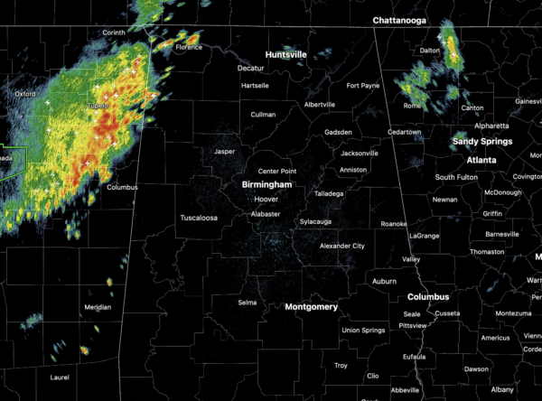
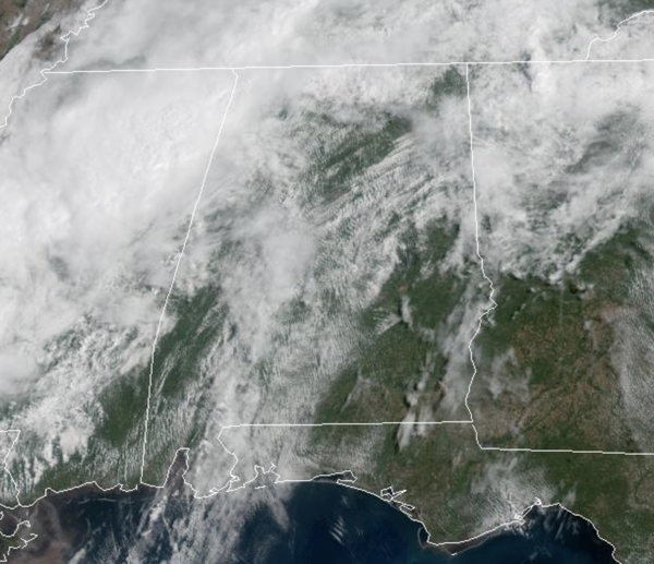
Showers and storms are once again on the radar today, and through the afternoon and evening, these will increase in coverage. However, they will remain scattered in nature and many locations will remain dry, while other locations will see brief, heavy downpours. The severe weather threat is very low, but we can’t completely rule out a storm or two possibly reach severe limits briefly with gusty winds and marginally severe hail. Of course, all storms will be producing frequent and dangerous lightning. We are seeing a mix of sun and clouds today and it remains warm and muggy with highs in the 80s.
BIRMINGHAM ALMANAC: For April 25th, the average high for Birmingham is 77° and the average low is 55°. The record high is 88° set in 2009, while the record low is 33° set in 1910. We average 0.17” of precipitation on this date and the record value is 2.10” set in 1980.
USA BRIEF: Thunderstorms, some severe, may produce heavy to excessive rainfall and isolated flooding over portions of the Southern Plains today and Saturday. Dry conditions, combined with gusty winds and low relative humidities will continue to support an elevated to critical fire weather threat in the Desert Southwest into to early next week.
WEEKEND WEATHER: Showers and storms become fewer in number and more isolated tomorrow and Sunday. The chance of any one spot seeing rain will be in the 20-30% range, meaning most spots stay dry. Most of the storms will occur during the afternoon and evening hours, however, rain will be possible at anytime. Despite the lower rain chances, the air mass will not change, as the days will feature a mix of sun and clouds, with highs in the 80s and lows in the 60s.
RACE WEEKEND: The weather will be warm and muggy, and though some showers and storms will remain a threat, most of the weekend should be dry for all the race weekend festivities. The chance of an afternoon shower/storm is in the 20-30% range; highs will remain in the 80s.
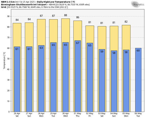
NEXT WEEK: Little change in the forecast with isolated showers and storms remaining a possibility for the first half of the week; highs will remain in the 80s. A front is expected over the second half of the week, and higher rain chances are expected by Thursday and Friday. Too early to tell if severe storms will be a threat, but tis the season. The front look to bring a late season cool snap for the first weekend of May as highs slip could slip down into the 70s with lows in the 50s.
WORLD TEMPERATURE EXTREMES: Over the last 24 hours, the highest observation outside the U.S. was 115.5F at Nawabshah, Pakistan. The lowest observation was -98.7F at Vostok, Antarctica.
CONTIGUOUS TEMPERATURE EXTREMES: Over the last 24 hours, the highest observation was 100F at Rio Grande Village, TX. The lowest observation was 16F at Angel Fire, NM.
Category: Alabama's Weather, ALL POSTS, Social Media
About the Author (Author Profile)
Macon, Georgia Television Chief Meteorologist, Birmingham native, and long time Contributor on AlabamaWX. Stormchaser. I did not choose Weather, it chose Me. College Football Fanatic. @Ryan_StinnetSubscribe
If you enjoyed this article, subscribe to receive more just like it.


