Stormy Saturday Ahead, Then Turning Slightly Quieter for the Week
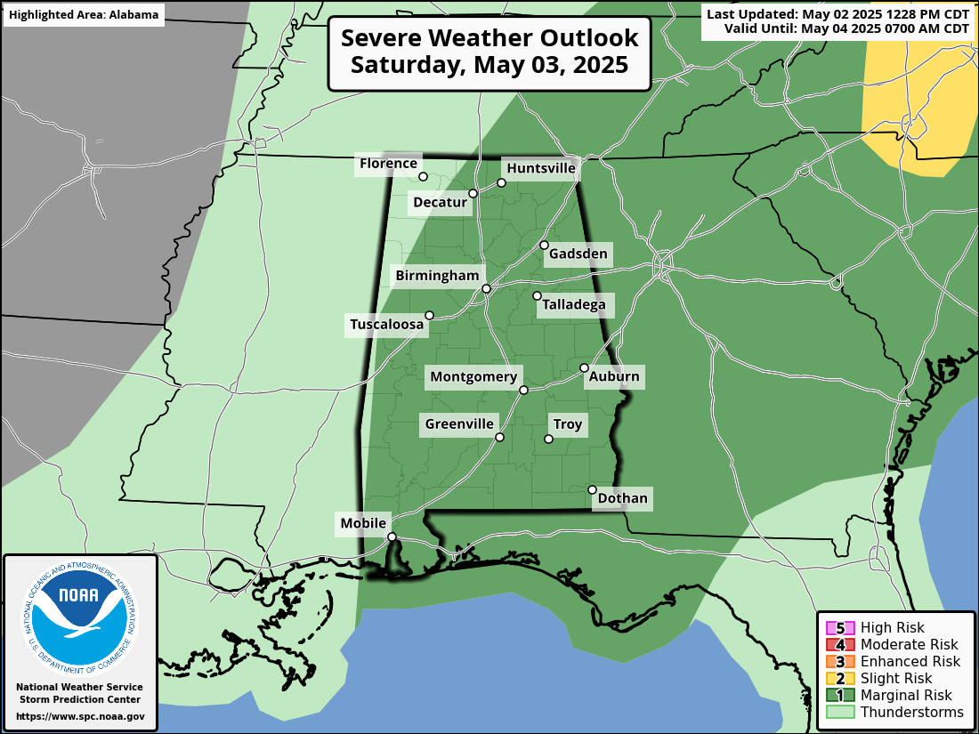
TODAY: A frontal boundary will gradually settle southward across the state during the day. Scattered to widespread thunderstorms are expected to develop from late morning through the afternoon. Some storms may become strong, with the potential for wind gusts up to 60 mph and small hail. There will likely be breaks between rounds of activity, though the exact timing of those lulls remains uncertain. Highs will range from the upper 60s to lower 80s, depending on cloud cover and rainfall.
SUNDAY: The system exits the region, with an upper-level low passing to our north. Skies will be mostly cloudy, and while a few light showers may develop across far northern counties, most of the state will remain dry. Highs once again will range from the upper 60s to lower 80s.
MONDAY THROUGH FRIDAY: A quiet start to the week with a mix of sun and clouds. Conditions stay mild and pleasant, with highs in the lower 70s to lower 80s. Partly sunny and warmer on Tuesday. A few isolated showers or storms may develop during the afternoon, but most areas will stay dry. Highs climb into the mid 70s to upper 80s. Wednesday will be partly sunny with a chance of scattered showers or storms, mainly later in the day. Highs will range from the mid 70s to mid 80s. Similar conditions continue on Thursday, with a mix of sun and clouds and a few passing showers or storms possible. Highs remain in the mid 70s to mid 80s. Slightly cooler to end the workweek. On Friday, clouds will increase, and there will be another chance of scattered showers and storms. Highs in the mid 70s to lower 80s.
SEVERE WEATHER SAFETY: Weather can be unpredictable, often catching us off guard with sudden changes. From thunderstorms and tornadoes to flash floods, being prepared can truly save lives. Alabama’s varied climate brings its share of severe weather, making it crucial for everyone to have a solid safety plan in place. For valuable tips on staying safe when severe weather threatens, check out our Severe Weather Safety Guide. Stay ready, stay safe!
BEACH FORECAST: Visit our Beach Forecast Center to get the latest weather and rip current forecasts for beaches from Fort Morgan to Panama City. This page allows you to select forecasts tailored to your destination, ensuring you have the most accurate and relevant information for your beach plans. Stay informed and safe on your coastal getaway!
ADVERTISE ON THE BLOG: Don’t miss this opportunity! Let us create a customized package tailored to the unique needs of your organization. Our solutions are creative, flexible, and competitively priced. For more information or inquiries, please contact Bill Murray at (205) 687-0782.
E-FORECAST SIGN UP: Get the Alabama Weather Blog’s comprehensive Seven-Day Forecast delivered straight to your inbox twice daily. Known as the most detailed forecast available in Central Alabama, our service ensures you’re always informed and prepared. Subscribe now and gain access to this valuable resource for free!
Category: Alabama's Weather, ALL POSTS, Severe Weather, Social Media, Weather Xtreme Videos
About the Author (Author Profile)
Scott Martin is an operational meteorologist, professional graphic artist, musician, husband, and father. Not only is Scott a member of the National Weather Association, but he is also the Central Alabama Chapter of the NWA president. Scott is also the co-founder of Racecast Weather, which provides forecasts for many racing series across the USA. He also supplies forecasts for the BassMaster Elite Series events including the BassMaster Classic.Subscribe
If you enjoyed this article, subscribe to receive more just like it.


