Midday Nowcast: Marvelous May Weather; Rain Returns Wednesday
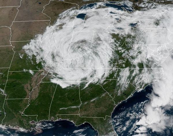
MARVELOUS MAY WEATHER: Enjoy the weather today and tomorrow, it will likely be October before we see weather this nice again across Alabama. We are seeing tons of sunshine today, with a few more clouds the farther north you go as an upper-level low spins over the Ohio River Valley. Highs today are in the low 70s. Tonight, will be another refreshing one across the state with upper 40s and lower 50s. Tomorrow, will be another great day of weather with plenty of sunshine and slightly warmer highs with mid to upper 70s expected. Late tomorrow, clouds will begin to increase, and some showers are likely to start sneaking into southwestern portions of the state.
BIRMINGHAM ALMANAC: For May 5th, the average high for Birmingham is 80° and the average low is 58°. The record high is 92° set in 1902, while the record low is 38° set in 1957. We average 0.16” of precipitation on this date and the record value is 2.56” set in 1908.
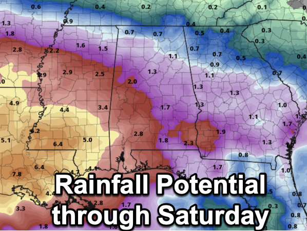
RAIN RETURNS: The upper-level low over the Ohio Valley will shift east the next few days, but another upper-level low over the Southwest will move east and settle in over the Southeast. An upper-level low is a weatherperson’s woe, as they can cause problematic forecast and that looks to be what we have ahead for Alabama and the Deep South. Occasional rain and storms are expected Wednesday through Friday as the upper low sits over the region. For now, severe storms are not expected, but a strong storm or two will be possible. Rain amounts will be in the 1-2 inch range for most of Alabama on these three days, but heavier amounts are possible mainly over the southern part of the state, where some spots could see 3-4 inches. Highs will remain in the 70s due to the clouds and rain.
THE ALABAMA WEEKEND: The upper low will still be a player in our weather, and we will keep occasional rain in the forecast both days. However, the upper-level low will be weakening as it slowly slides eastwards and showers should become fewer in number by Sunday. Highs will be in the mid to upper 70s. For now, much of next week looks drier and warmer with highs returning to the 80s Tuesday through Friday.
WORLD TEMPERATURE EXTREMES: Over the last 24 hours, the highest observation outside the U.S. was 115.7F at Al Ahsa, Saudi Arabia. The lowest observation was -94.4F at Concordia, Antarctica.
CONTIGUOUS TEMPERATURE EXTREMES: Over the last 24 hours, the highest observation was 97F at Rio Grande Village, TX. The lowest observation was 23F at Peter Sinks, UT; Meacham, OR; Foxpark, WY; and Wolf Creek Pass, CO.
Category: Alabama's Weather, ALL POSTS, Social Media
About the Author (Author Profile)
Macon, Georgia Television Chief Meteorologist, Birmingham native, and long time Contributor on AlabamaWX. Stormchaser. I did not choose Weather, it chose Me. College Football Fanatic. @Ryan_StinnetSubscribe
If you enjoyed this article, subscribe to receive more just like it.


