Midday Nowcast: Severe Weather Outbreak North of Alabama Today; Some Severe Storms Possible this Weekend
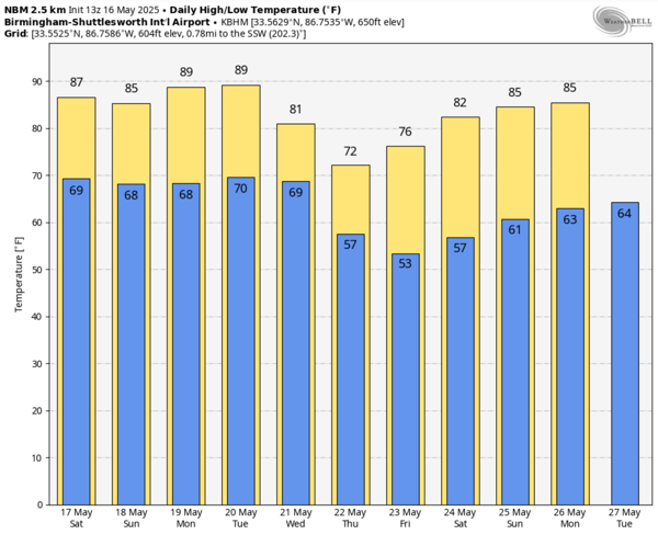
Today remains dry and hot across Alabama with a mix of sun and clouds. Afternoon highs will range from the upper 80s to lower 90s across all of Alabama.
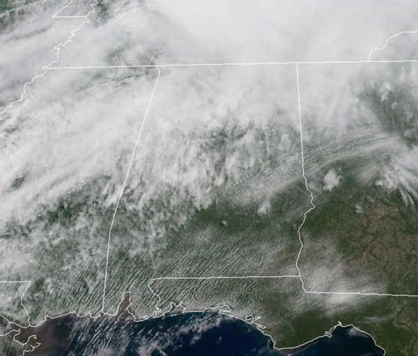
To our north A regional outbreak of severe thunderstorms is likely this afternoon into tonight across parts of the mid Mississippi, Ohio and Tennessee Valleys. This will include intense supercells associated with tornadoes, large hail and wind damage. Several strong tornadoes are expected, and a long-track high-end tornado will be possible. From the evening into the overnight, a bowing line segment is expected to form with the potential for tornadoes and damaging winds, with some gusts possibly greater than 75 mph.
Some of the storms will drop into North Alabama overnight through early tomorrow morning as the cold front sinks south. These storms will be weakening as they move south, but will have the potential to produce gusty winds and hail. They will approach the Alabama/Tennessee line around midnight, and should be closer to the Interstate 20 corridor by sunrise tomorrow morning.
BIRMINGHAM ALMANAC: For May 16th, the average high for Birmingham is 82° and the average low is 61°. The record high is 97° set in 1962, while the record low is 43° set in 1973. We average 0.17” of precipitation on this date and the record value is 2.30” set in 1980.
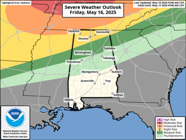
SOME STRONG STORMS THIS WEEKEND: The front slowly moves south into Alabama, and as daytime heating allows instability to increase, we are expecting additional showers and storms to develop late tomorrow afternoon and evening. These will be scattered in nature, and rather random where they develop. Know it won’t rain everywhere, but where storms develop and move, they will pack a punch producing strong, gusty winds and some hail, along with heavy rainfall and frequent lightning.
The Storm Prediction Center maintains a “marginal risk” (level 1 of 5) of severe storms tomorrow for the northern two-thirds of the state. These will be predominantly driven by daytime heating, and should begin to weaken and dissipate after sunset.
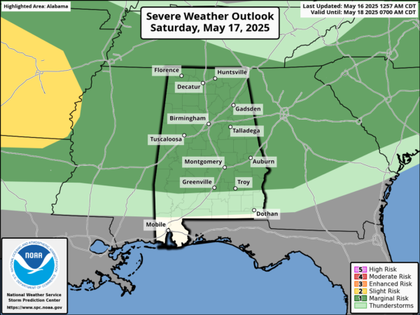
Sunday will be a near repeat of tomorrow as the front will be stalled across northern portions of the state. Scattered, random thunderstorms will develop during the afternoon and evening hours. Again, these could produce gusty winds and hail.
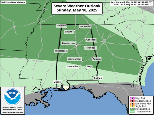
The Storm Prediction Center has issued a “marginal risk” (level 1 of 5) of severe storms for much of Alabama, for the threat of these strong storms. The tornado threat is very low, but not zero both days. Bottom line is that the weekend certainly won’t be a wash-out, but from time to time there will be some showers and thunderstorms.
NEXT WEEK: Monday and Tuesday will be warm and muggy weather with highs in the 80s. Both days will generally be dry, but there will be some random, isolated afternoon and evening storms. Late Tuesday night and into Wednesday, a stronger cold front will bring rain and storms back to Alabama and the Deep South. Some strong storms will be possible as well. This front is forecast to push through the state, bringing a late season cool snap. Highs will fall into the 70s Thursday and Friday; lows will be mostly in the 50s and some spots in North Alabama dip into the 40s.
WORLD TEMPERATURE EXTREMES: Over the last 24 hours, the highest observation outside the U.S. was 117.3F at Zabol, Iran. The lowest observation was -103.9F at Vostok, Antarctica.
CONTIGUOUS TEMPERATURE EXTREMES: Over the last 24 hours, the highest observation was 109F at Faith Ranch, TX. The lowest observation was 15F at Peter Sinks, UT.
Category: Alabama's Weather, ALL POSTS, Social Media
About the Author (Author Profile)
Macon, Georgia Television Chief Meteorologist, Birmingham native, and long time Contributor on AlabamaWX. Stormchaser. I did not choose Weather, it chose Me. College Football Fanatic. @Ryan_StinnetSubscribe
If you enjoyed this article, subscribe to receive more just like it.


