Midday Nowcast: Muggy Monday; More Severe Storms Expected Tuesday Night
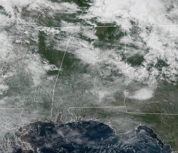
We are seeing a mix of sun and clouds with highs in the upper 80s with some low 90s are showing up. A few isolated showers and storms are possible this afternoon and tonight; most places will be rain-free. Not much change tomorrow; expect partly sunny and very warm conditions with highs in the upper 80s. Any showers during the day will remain isolated, but tomorrow night storms will roll into Alabama.
BIRMINGHAM ALMANAC: For May 19th, the average high for Birmingham is 83° and the average low is 62°. The record high is 98° set in 1962, while the record low is 43° set in 1976. We average 0.16” of precipitation on this date and the record value is 3.13” set in 1983.
WEEKEND REVIEW: First off, over this past week, all the damage that occurred across Central Alabama was a result of damaging straight-line winds, not tornadoes. The numerous severe thunderstorms warnings that we issued included winds of 60-80 mph and produced tremendous amounts of wind damage in portions of Alabama. This is another example of why we say take all severe weather warnings seriously, not just tornado warnings. Severe thunderstorm warned storms are just as dangerous and yesterday proved that…it doesn’t matter what caused trees to fall on your house or car, you are now dealing with a mess. So please, take all severe weather warnings seriously!!!
MORE SEVERE STORMS: Tomorrow another round of widespread severe weather will occur across the Ohio Valley and Tennessee Valley, and this threat extends into Alabama. For Alabama, the threat will come tomorrow night. The Storm Prediction Center has an “enhanced risk” (level 3/5) of severe thunderstorms for Northwest Alabama, a “slight risk” (level 2/5) down to Greensboro, Calera, and Heflin, and a “marginal risk (level 1/5) as far south as Thomasville, Prattville, and Lafayette.
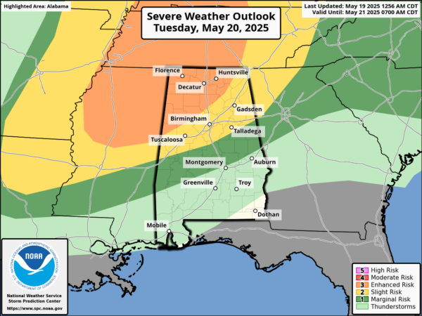
TIMING: A line of severe thunderstorms will likely enter the northwest corner of the state around 6:00 p.m… it will move through the northern half of the state tomorrow night. The line of storms should reach the Interstate 20 corridor, Tuscaloosa/Birmingham/Gadsden/Anniston in the 9-11 p.m. time frame and will likely weaken over Central Alabama after midnight as the upper support moves away.
The primary threat will come from damaging winds since high resolution models suggest the storms will be linear. However, some tornadoes are certainly possible within the line as well, especially if any discrete storms form ahead of the line, the tornado risk will be higher. The SPC is highlighting a higher tornado risk for portions of Alabama for this possibility.
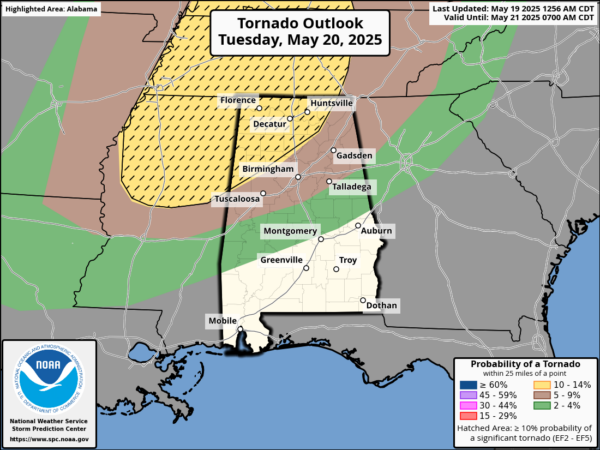
Large hail is also possible in a few spots within the line. Again, take both severe thunderstorm and tornado warnings seriously, and take the same safety actions for both!!!
GREAT WEATHER: Wednesday will be dry with a high in the low 80s. Cooler and drier air will settle into the state for a few days, and most communities will stay rain-free Thursday and Friday. Highs will be in the 70s while lows will be in the 50s. Some of the cooler spots over North Alabama could reach the upper 40s early Friday morning.
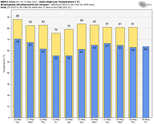
MEMORIAL DAY WEEKEND: Moisture levels begin to rise and we will have to mention the chance for scattered showers and storms over the northern half of the state both Saturday and Sunday. Showers and storms are more likely Monday with the approach of a cold front. Highs through the holiday will be in the 80s, while lows will be in the 60s.
WORLD TEMPERATURE EXTREMES: Over the last 24 hours, the highest observation outside the U.S. was 118.9F at Ahwaz, Iran. The lowest observation was -104.6F at Vostok, Antarctica.
CONTIGUOUS TEMPERATURE EXTREMES: Over the last 24 hours, the highest observation was 108F at Rio Grande Village, TX. The lowest observation was 20F at Stehekin, WA.
Category: Alabama's Weather, ALL POSTS, Social Media
About the Author (Author Profile)
Macon, Georgia Television Chief Meteorologist, Birmingham native, and long time Contributor on AlabamaWX. Stormchaser. I did not choose Weather, it chose Me. College Football Fanatic. @Ryan_StinnetSubscribe
If you enjoyed this article, subscribe to receive more just like it.


