Midday Nowcast: Quiet for Now; Severe Storms this Evening and Tonight
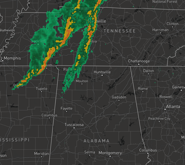
STRONG AND SEVERE STORMS ON THE WAY: Most of us are dry today, but we are seeing some showers and storms across the Tennessee Valley of the state. Widespread severe storms will develop this afternoon to our north, and these will move south into and through Alabama this evening and overnight.
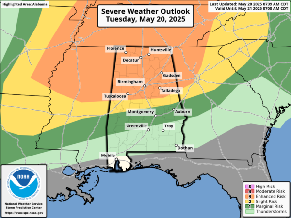
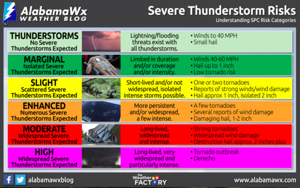
PLACEMENT: The Storm Prediction Center expanded the “enhanced risk” (level 3/5) of severe thunderstorms as far south as Moundville, Jemison, and Wedowee, so the northern half of the state. There is a “slight risk” (level 2/5) as far south as Demopolis, Marbury, and Lafayette. And, a “marginal risk” (level 1/5) down to Grove Hill, Highland Home, and Phenix City. Just a reminder how the Storm Prediction Center defines each of its risk categories.
THREATS: This is more of a classic, spring-time severe weather setup for Alabama and therefore all modes of severe weather are possible over the northern half of Alabama with this event. The highest risk of tornadoes is in the “enhanced risk” in any discrete cells that form ahead of the main line. A strong tornado (EF-2 or higher) can’t be ruled out.
As the storms evolve into a line, a couple of brief, isolated tornadoes are still possible, but being more linear, the main threat will shift to damaging straight line winds, possibly 70 mph in spots. Also, large hail is also possible with the stronger thunderstorms. As the storm continue to move south through the state overnight, they will begin weakening and should be falling below severe limits as they head south of the US 80 corridor from Demopolis to Selma to Montgomery.
TIMING: The core threat looks to impact North Alabama during the 5-9PM window, and as the storms drop south, the window for the Interstate 20 corridor will be in the 8PM-Midnight time frame, and then continuing south of Clanton in the 11PM-3AM window.
CALL TO ACTION: Events like this are common in Alabama in May, which is part of our tornado season (which runs from November through May). No need to be worried or anxious, just have a reliable way of hearing warnings (never an outdoor siren!), have a good plan, and we will get through it together.
URGENT REMINDER
NOAA Weather Radio is currently out of service across central Alabama due to a scheduled system upgrade at the National Weather Service in Birmingham. This means you won’t hear watches or warnings on your radio until at least May 21. Make sure you have other reliable ways to receive alerts—like wireless emergency alerts on your phone, local TV and radio, or a trusted weather app—so you don’t miss critical updates during tonight’s severe weather threat.
Know the safe place in your house, and in that safe place have helmets for everyone. Bicycle helmets and batting helmets work well. We also recommend portable air horns and hard soled shoes for everyone. If you live in an apartment complex, you can’t be above the first level. Shelter with a friend on the ground level, or ask management if they can open the clubhouse during a tornado warning.
If you live in a mobile home, you cannot stay there during a tornado warning, they offer little to know protection from severe storms. Know the location of the nearest shelter, or business that is open 24/7. Know how to get there quickly.
A car is a death trap during a tornado. If you are driving and get a tornado warning notification, pull off as quickly as possible and go into a gas station, fast food restaurant, or any other business that can serve as a shelter.
Be a hero, and you can help us. Tell your friends, neighbors, and relatives about the threat, and what they need to do to get ready. And, if they fall in a tornado warning polygon, call them or text them to let them know about the threat. You are our most valuable resource in spreading the word!
BIRMINGHAM ALMANAC: For May 20th, the average high for Birmingham is 83° and the average low is 62°. The record high is 97° set in 1962, while the record low is 41° set in 2002. We average 0.16” of precipitation on this date and the record value is 2.65” set in 2017.
MARVELOUS MAY WEATHER: Tomorrow will be dry with a high in the low 80s. Cooler and drier air will settle into the state for a few days, and most communities will stay rain-free through Friday. Highs will be in the 70s over the northern half of the state, while 80s are expected over South Alabama. Lows will be in the 50s, and some cooler spots over North Alabama could reach the upper 40s early Friday morning.
MEMORIAL DAY WEEKEND: Moisture levels begin to rise and we will have to mention the chance for scattered showers and storms over the northern half of the state both Saturday and Sunday. Showers and storms are more likely Monday with the approach of a cold front. Highs through the holiday will be in the 80s, while lows will be in the 60s.
WORLD TEMPERATURE EXTREMES: Over the last 24 hours, the highest observation outside the U.S. was 122.0F at Bandar-E-Dayyer, Iran. The lowest observation was -106.6F at Vostok, Antarctica.
CONTIGUOUS TEMPERATURE EXTREMES: Over the last 24 hours, the highest observation was 109F at Faith Ranch, TX. The lowest observation was 15F at Manila, UT.
Category: Alabama's Weather, ALL POSTS, Severe Weather, Social Media
About the Author (Author Profile)
Macon, Georgia Television Chief Meteorologist, Birmingham native, and long time Contributor on AlabamaWX. Stormchaser. I did not choose Weather, it chose Me. College Football Fanatic. @Ryan_StinnetSubscribe
If you enjoyed this article, subscribe to receive more just like it.


